Difference between revisions of "2015-06-25 52 1"
From Geohashing
imported>Sourcerer m (→New Expedition) |
imported>FippeBot m (Location) |
||
| (6 intermediate revisions by one other user not shown) | |||
| Line 3: | Line 3: | ||
| lon=1 | | lon=1 | ||
| date=2015-06-25 | | date=2015-06-25 | ||
| + | | graticule_name=Norwich, UK | ||
| + | | graticule_link=Norwich, United Kingdom | ||
}} | }} | ||
__NOTOC__ | __NOTOC__ | ||
| Line 27: | Line 29: | ||
<gallery perrow="5"> | <gallery perrow="5"> | ||
Image:2015-06-25_52_1_Sourcerer_1435187264665.jpg | Proof. [http://www.openstreetmap.org/?lat=52.13658571&lon=1.09082222&zoom=16&layers=B000FTF @52.1366,1.0908] | Image:2015-06-25_52_1_Sourcerer_1435187264665.jpg | Proof. [http://www.openstreetmap.org/?lat=52.13658571&lon=1.09082222&zoom=16&layers=B000FTF @52.1366,1.0908] | ||
| + | Image:2015-06-25 52 1 Sourcerer.jpg | Google Earth Track Log | ||
</gallery> | </gallery> | ||
| Line 35: | Line 38: | ||
| longitude = 1 | | longitude = 1 | ||
| date = 2015-06-25 | | date = 2015-06-25 | ||
| − | |||
| − | |||
| − | |||
| − | |||
| − | |||
| − | |||
| − | |||
| name = Sourcerer | | name = Sourcerer | ||
}} | }} | ||
| Line 48: | Line 44: | ||
| prev = 2015-06-24 52 1 | | prev = 2015-06-24 52 1 | ||
| curr = 2015-06-25 52 1 | | curr = 2015-06-25 52 1 | ||
| + | | next = 2015-06-26 52 1 | ||
| date = 2015-06-25 | | date = 2015-06-25 | ||
}} | }} | ||
| Line 54: | Line 51: | ||
[[Category:Expeditions with photos]] | [[Category:Expeditions with photos]] | ||
[[Category:Coordinates reached]] | [[Category:Coordinates reached]] | ||
| + | {{location|GB|ENG|SFK}} | ||
Latest revision as of 04:09, 15 August 2019
| Thu 25 Jun 2015 in Norwich, UK: 52.1365838, 1.0908543 geohashing.info google osm bing/os kml crox |
Location
In a field by a bridleway between Coddenham and the A14, Suffolk, UK.
Participants
Plans
Expedition two of two spanning midnight. 2015-06-24 52 1 - 2015-06-25 52 1
Expedition
- Arrived. -- Sourcerer (talk) @52.1366,1.0908 00:08, 25 June 2015 (GMT+01:00)
There was space to park at the start of the bridleway. A narrow track widened to farm access width. A left turn led through an avenue with old pine trees on both sides. Then there was another left turn into a sugar beet field, daintily stepping between the plants.
Photos
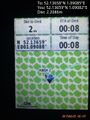
Proof. @52.1366,1.0908
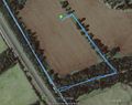
Google Earth Track Log


Achievements
Sourcerer earned the Midnight Geohash achievement
|
Expeditions and Plans
| 2015-06-25 | ||
|---|---|---|
| Regensburg, Germany | Danatar | in the Mühlholz forest near Regenstauf. Country: Germany; state: Bayern (B... |
| Chemnitz, Germany | Danatar | in a wet meadow directly next to a small pond, near the river Eger/Ohře, ne... |
| Norwich, United Kingdom | Sourcerer | In a field by a bridleway between Coddenham and the A14, Suffolk, UK. |
Sourcerer's Expedition Links
2015-06-24 52 1 - 2015-06-25 52 1 - 2015-06-26 52 1 - KML file download of Sourcerer's expeditions for use with Google Earth.