Difference between revisions of "2015-07-08 52 1"
From Geohashing
imported>Sourcerer m ([live picture] Proof (early). [http://www.openstreetmap.org/?lat=52.45548427&lon=1.19050920&zoom=16&layers=B000FTF @52.4555,1.1905]) |
imported>Sourcerer m ([live picture] Still here. [http://www.openstreetmap.org/?lat=52.45548427&lon=1.19047701&zoom=16&layers=B000FTF @52.4555,1.1905]) |
||
| Line 29: | Line 29: | ||
Image:2015-07-08_52_1_Sourcerer_1436309500244.jpg | Proof (early). [http://www.openstreetmap.org/?lat=52.45548427&lon=1.19050920&zoom=16&layers=B000FTF @52.4555,1.1905] | Image:2015-07-08_52_1_Sourcerer_1436309500244.jpg | Proof (early). [http://www.openstreetmap.org/?lat=52.45548427&lon=1.19050920&zoom=16&layers=B000FTF @52.4555,1.1905] | ||
| + | |||
| + | Image:2015-07-08_52_1_Sourcerer_1436310005148.jpg | Still here. [http://www.openstreetmap.org/?lat=52.45548427&lon=1.19047701&zoom=16&layers=B000FTF @52.4555,1.1905] | ||
</gallery> | </gallery> | ||
Revision as of 23:00, 7 July 2015
| Wed 8 Jul 2015 in 52,1: 52.4554961, 1.1906588 geohashing.info google osm bing/os kml crox |
Location
Close to a public footpath south of Great Moulton, Norfolk, UK.
Participants
Plans
Expedition two of two spanning midnight - 2015-07-07 52 1 - 2015-07-08 52 1 - ETA 00:00.
Expedition
- Arrived early. -- Sourcerer (talk) @52.4555,1.1905 23:50, 7 July 2015 (GMT+01:00)
Photos
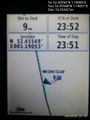
Proof (early). @52.4555,1.1905
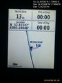
Still here. @52.4555,1.1905


Achievements
Expeditions and Plans
| 2015-07-08 | ||
|---|---|---|
| McMinnville, Oregon | Jim | Ag land off Bald Peak Road |
| München, Germany | Juja, Hans | Not even 100 meters from a road near Aichach, Bavaria. |
| Norwich, United Kingdom | Sourcerer | Close to a public footpath south of Great Moulton, Norfolk, UK. |
Sourcerer's Expedition Links
2015-07-07 52 1 - 2015-07-08 52 1 - 2015-07-09 52 1 - KML file download of Sourcerer's expeditions for use with Google Earth.