Difference between revisions of "2015-08-26 52 0"
From Geohashing
imported>Sourcerer m ([live picture] Proof. [http://www.openstreetmap.org/?lat=52.00321019&lon=.97716630&zoom=16&layers=B000FTF @52.0032,.9772]) |
imported>Sourcerer m (→New expedition) |
||
| Line 20: | Line 20: | ||
== Expedition == | == Expedition == | ||
| + | *Arrived. -- [[User:Sourcerer|Sourcerer]] ([[User talk:Sourcerer|talk]]) [http://www.openstreetmap.org/?lat=52.00321019&lon=.97716630&zoom=16&layers=B000FTF @52.0032,.9772] 00:00, 26 August 2015 (GMT+01:00) | ||
| + | There was parking in the gateway to the golf course. The route was through quite long, very wet grass. The woodland had a path through it. The hashpoint was in the clearing, just as expected. | ||
| − | |||
| − | |||
== Photos == | == Photos == | ||
<gallery perrow="5"> | <gallery perrow="5"> | ||
| − | |||
| − | |||
Image:2015-08-26_52_0_Sourcerer_1440543559461.jpg | Proof. [http://www.openstreetmap.org/?lat=52.00321019&lon=.97716630&zoom=16&layers=B000FTF @52.0032,.9772] | Image:2015-08-26_52_0_Sourcerer_1440543559461.jpg | Proof. [http://www.openstreetmap.org/?lat=52.00321019&lon=.97716630&zoom=16&layers=B000FTF @52.0032,.9772] | ||
| + | Image:2015-08-26 52 0 Sourcerer.jpg | Track in Google Earth | ||
</gallery> | </gallery> | ||
== Achievements == | == Achievements == | ||
{{#vardefine:ribbonwidth|700px}} | {{#vardefine:ribbonwidth|700px}} | ||
| − | + | {{Midnight geohash | |
| + | | latitude = 52 | ||
| + | | longitude = 0 | ||
| + | | date = 2015-08-26 | ||
| + | | name = Sourcerer | ||
| + | }} | ||
{{Sourcerer_links | {{Sourcerer_links | ||
| Line 43: | Line 47: | ||
}} | }} | ||
| − | |||
| − | |||
[[Category:Expeditions]] | [[Category:Expeditions]] | ||
[[Category:Expeditions with photos]] | [[Category:Expeditions with photos]] | ||
[[Category:Coordinates reached]] | [[Category:Coordinates reached]] | ||
| − | |||
Revision as of 01:03, 26 August 2015
| Wed 26 Aug 2015 in 52,0: 52.0032205, 0.9771370 geohashing.info google osm bing/os kml crox |
Location
Brett Vale Golf Club - with a public footpath close to the woodland clearing hashpoint.
Participants
Plans
Expedition three of three spanning midnight - 2015-08-25 52 1 - 2015-08-25 52 0 - 2015-08-26 52 0 - ETA 00:00
Expedition
- Arrived. -- Sourcerer (talk) @52.0032,.9772 00:00, 26 August 2015 (GMT+01:00)
There was parking in the gateway to the golf course. The route was through quite long, very wet grass. The woodland had a path through it. The hashpoint was in the clearing, just as expected.
Photos
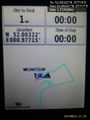
Proof. @52.0032,.9772
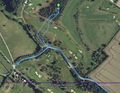
Track in Google Earth


Achievements
Sourcerer earned the Midnight Geohash achievement
|
Expeditions and Plans
| 2015-08-26 | ||
|---|---|---|
| Cambridge, United Kingdom | Sourcerer | 3) Brett Vale Golf Club - with a public footpath close to the woodland clea... |
Sourcerer's Expedition Links
2015-08-25 52 0 - 2015-08-26 52 0 - 2015-08-27 52 1 - KML file download of Sourcerer's expeditions for use with Google Earth.