Difference between revisions of "2015-09-25 45 -122"
imported>Michael5000 (Created page with " thumb|left {{meetup graticule | lat=45 | lon=-122 | date=2015-09-25 }} <!-- edit as necessary --> __NOTOC__ == Location == In the Pa...") |
imported>FippeBot m (Location) |
||
| Line 46: | Line 46: | ||
[[Category:Expeditions with photos]] | [[Category:Expeditions with photos]] | ||
[[Category:Coordinates reached]] | [[Category:Coordinates reached]] | ||
| + | {{location|US|OR|YA}} | ||
Revision as of 05:14, 15 August 2019

| Fri 25 Sep 2015 in 45,-122: 45.2603419, -122.8930985 geohashing.info google osm bing/os kml crox |
Location
In the Parrett Mountain Willamette River access park, near Newberg.
Participants
- a deer
- Michael5000
Expedition
After the 2015-09-25 46 -122 expedition, I crossed back into Oregon at Rainier, went east on US 30 and then south on Oregon 47, and came to Vernonia. At Vernonia, I went for a long run on the Banks-Vernonia Trail, then continued driving south through Forest Grove, Yamhill, and Newberg. From Newberg, I started west on the Wilsonville Road, and stopped at the access park. The field was a bit overgrown, but not at all difficult to walk through. I startled a geohashing deer as I approached the site; I'm mentioning that because he or she will probably not be able to write up the expedition him or herself, what with the hooves and poor forest wifi availability.
Photos
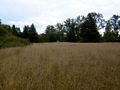
View from the hashpoint. The expedition vehicle is just visible.
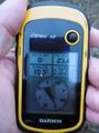
Yes, I reached this hashpoint, too.

Here I am again.
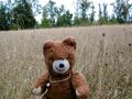
With my ursine hashscot companion.


Achievements
Michael5000 earned the Multihash Achievement
|