Difference between revisions of "2015-09-27 52 0"
imported>Tongs (→Photos) |
imported>FippeBot m (Location) |
||
| (3 intermediate revisions by 2 users not shown) | |||
| Line 1: | Line 1: | ||
| − | |||
| − | |||
| − | |||
| − | |||
| − | |||
| − | |||
| − | |||
| − | |||
| − | |||
| − | |||
{{meetup graticule | {{meetup graticule | ||
| lat=52 | | lat=52 | ||
| lon=0 | | lon=0 | ||
| date=2015-09-27 | | date=2015-09-27 | ||
| + | | graticule_name=Cambridge, UK | ||
| + | | graticule_link=Cambridge, United Kingdom | ||
}} | }} | ||
| + | __NOTOC__ | ||
| − | + | Update: This has come to be thought of as the best expedition yet. | |
| − | |||
== Location == | == Location == | ||
| Line 43: | Line 35: | ||
The hashpoint was in the very next field. A field ploughed with straw. We walked carefully along the edge and then 170m into the field, to reach the hashpoint, not long after the originally planned time of 4pm. Luckily, we found a small gap in the hedge only a few hundreds metres away and walked back along the road back to the car. And maybe another pint in the pub. And dinner. And then home for real. | The hashpoint was in the very next field. A field ploughed with straw. We walked carefully along the edge and then 170m into the field, to reach the hashpoint, not long after the originally planned time of 4pm. Luckily, we found a small gap in the hedge only a few hundreds metres away and walked back along the road back to the car. And maybe another pint in the pub. And dinner. And then home for real. | ||
| − | |||
| − | |||
| − | |||
== Photos == | == Photos == | ||
<gallery perrow="5"> | <gallery perrow="5"> | ||
Image:2015-09-27 52 0 blackberries.jpg | Picking blackberries in the next field. | Image:2015-09-27 52 0 blackberries.jpg | Picking blackberries in the next field. | ||
| + | Image:2015-09-27 52 0 solids.jpg | Some connected Platonic solids. | ||
Image:2015-09-27 52 0 supernova.jpg | Playing on the Tongs' favourite piece of playground equipment. | Image:2015-09-27 52 0 supernova.jpg | Playing on the Tongs' favourite piece of playground equipment. | ||
</gallery> | </gallery> | ||
| Line 56: | Line 46: | ||
[[Category:Expeditions]] | [[Category:Expeditions]] | ||
| + | [[Category:Expeditions with photos]] | ||
[[Category:Coordinates reached]] | [[Category:Coordinates reached]] | ||
| + | {{location|GB|ENG|CAM}} | ||
Latest revision as of 05:17, 15 August 2019
| Sun 27 Sep 2015 in Cambridge, UK: 52.3563794, 0.1665555 geohashing.info google osm bing/os kml crox |
Update: This has come to be thought of as the best expedition yet.
Location
A field between the villages of Haddenham and Wilburton, near Ely.
The field is accessible by road or track, providing there's a way through or around that hedge...
Participants
- The Tongs
Plans
We aimed to be at the hashpoint at 4pm.
We were going to visit Milton Country Park, who are holding their Autumn Festival today. M prepared a picnic.
Expedition
The plan was to drive north and stop off at Milton Park for the Autumn Fair. Strands of police tape festooned the road which led there, so we pressed on, up the A10 to Stretham, and into Haddenham. We were therefore far too early for our planned time of 4pm, but as we didn’t rate this a particularly high-quality hashpoint we figured nobody would turn up anyway. We parked in a small car park and, looking across to the play area nearby, we realised we had struck gold. Not only was there a Kompan Supernova to play on, but there was a set of connected Platonic solids to climb on. F identified it as part of a 120-cell, or maybe a 600-cell. B climbed up it and slid down again while M was being pushed high enough on the swing to elicit screaming noises. We played on the Supernova for maybe 45 minutes, including games of ‘get to the top’, during which time others joined in.
We went off for a quick pint at the local pub, The Three Kings, and headed back to the beginning of the footpath that would eventually take us to the hashpoint. Despite being challenged by a bad case of stitch, we pushed on, following the arrow on the GPS receiver. Perhaps we were doing so a bit too slavishly, since we were walking through a spiky field (note: wear trousers next time) when we could have been walking on a nicely-maintained track the other side of a blackberry hedge.
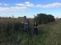
BLACKBERRIES! Suddenly the expedition had changed focus: pick enough blackberries for a pie. It was lucky that B has such a fat head, because his cap (and F’s) served as the main storage container for the blackberries. In the end we had two very ripe hatfuls of blackberries, two purple-stained hats, and plans to make a blackberry pie back at HQ. While picking, we met a couple and their initially very timid dog. T correctly deduced that they weren’t geohashers, because they didn’t look like Rastamouse (a reference to Sourcerer’s user page).
The hashpoint was in the very next field. A field ploughed with straw. We walked carefully along the edge and then 170m into the field, to reach the hashpoint, not long after the originally planned time of 4pm. Luckily, we found a small gap in the hedge only a few hundreds metres away and walked back along the road back to the car. And maybe another pint in the pub. And dinner. And then home for real.
Photos
Picking blackberries in the next field.
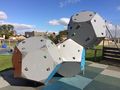
Some connected Platonic solids.
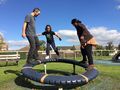
Playing on the Tongs' favourite piece of playground equipment.


