Difference between revisions of "2015-11-13 52 1"
imported>Sourcerer m (→Je Suis France) |
imported>Sourcerer m (→Added graticule name) |
||
| Line 3: | Line 3: | ||
| lon=1 | | lon=1 | ||
| date=2015-11-13 | | date=2015-11-13 | ||
| + | | graticule_name=Norwich, UK | ||
| + | | graticule_link=Norwich, United Kingdom | ||
}} | }} | ||
__NOTOC__ | __NOTOC__ | ||
Revision as of 14:31, 2 December 2015
| Fri 13 Nov 2015 in Norwich, UK: 52.6169794, 1.1231043 geohashing.info google osm bing/os kml crox |

Location
In a meadow west of the river Tiffey, south of Barford, Norfolk, UK.
Participants
Plans
Expedition two of two spanning midnight - 2015-11-12 52 0 - 2015-11-13 52 1 - ETA 00:00.
Expedition
There was no 3G signal in this area. There was a parking place in a side road. After crossing the main road, a narrow lane led towards the hashpoint. This was signed "Private, Access Only" which I assumed applied to vehicles. After the houses, there was a gate to block vehicles but with pedestrian access on either side. The lane continued past fields and under power lines. A left turn led across stubble to a belt of sweet corn. The perimeter led back to a track and later a stile gave access to the meadow. Now it was just a case of setting a course to reach the hashpoint. The whole route seemed to have been designed for convenient access.
Photos
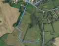
Track in Google Earth
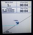
Proof.


Achievements
Sourcerer earned the Midnight Geohash achievement
|
Expeditions and Plans
| 2015-11-13 | ||
|---|---|---|
| Norwich, United Kingdom | Sourcerer | In a meadow west of the river Tiffey, south of Barford, Norfolk, UK. |
| Hamburg (East), Germany | OtherJack | Garden of a nursery school in the Farmsen neighborhood of Hamburg |
Sourcerer's Expedition Links
2015-11-12 52 0 - 2015-11-13 52 1 - 2015-11-14 52 1 - KML file download of Sourcerer's expeditions for use with Google Earth.