Difference between revisions of "2015-12-01 52 1"
From Geohashing
imported>Sourcerer m ([live] Arrived.) |
imported>Sourcerer m ([live picture] Proof. [http://www.openstreetmap.org/?lat=52.07172990&lon=1.14259958&zoom=16&layers=B000FTF @52.0717,1.1426]) |
||
| Line 26: | Line 26: | ||
== Photos == | == Photos == | ||
<gallery> | <gallery> | ||
| + | |||
| + | Image:2015-12-01_52_1_Sourcerer_1449010714407.jpg | Proof. [http://www.openstreetmap.org/?lat=52.07172990&lon=1.14259958&zoom=16&layers=B000FTF @52.0717,1.1426] | ||
</gallery> | </gallery> | ||
Revision as of 23:03, 1 December 2015
| Tue 1 Dec 2015 in 52,1: 52.0716955, 1.1425712 geohashing.info google osm bing/os kml crox |
Location
In public parkland, north Ipswich, Suffolk, UK. This is 115 metres from 2015-05-05 52 1.
Participants
Plans
Expedition one of two spanning midnight - 2015-12-01 52 1 - 2015-12-02 52 1 - ETA 23:00. The point looks as though it's on the border between a private garden and the parkland. Leaning over the fence might be needed. A retro expedition might be unavoidable.
Expedition
- Arrived. -- Sourcerer (talk) @52.0717,1.1425 23:01, 1 December 2015 (GMT)
Photos
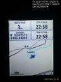
Proof. @52.0717,1.1426

Achievements
Expeditions and Plans
| 2015-12-01 | ||
|---|---|---|
| Ottawa, Ontario | Someone went | Testing Android geohash app -- Jlam (talk) @45.4010,-75.7418 10:01, 1 Dece... |
| München, Germany | TheOneRing | on a meadow at Inning. |
| Pforzheim, Germany | RecentlyChanged | Steep hill. |
| Norwich, United Kingdom | Sourcerer | In public parkland, north Ipswich, Suffolk, UK. This is 115 metres from 2015-05-05 52 1. |
| Utrecht, Netherlands | xnyhps | Near a greenhouse next to Utrecht, The Netherlands. |
Sourcerer's Expedition Links
2015-11-30 52 1 - 2015-12-01 52 1 - 2015-12-02 52 1 - KML file download of Sourcerer's expeditions for use with Google Earth.