Difference between revisions of "2015-12-13 52 1"
imported>Sourcerer m (→Achievements) |
imported>Sourcerer m (→New expedition) |
||
| Line 10: | Line 10: | ||
== Location == | == Location == | ||
| − | In a | + | In a field, soon to be a new housing estate, west of Costessey, Norwich, Norfolk, UK. |
== Participants == | == Participants == | ||
| Line 20: | Line 20: | ||
There seems to be a building site here or perhaps new houses, recently completed. | There seems to be a building site here or perhaps new houses, recently completed. | ||
| − | Expedition one of | + | Expedition one of three spanning midnight - [[2015-12-13 52 1]] - [[2013-09-22 52 1|2013-09-22 52 1 Retro]] - [[2015-12-14 52 1]] - ETA 23:10. |
== Expedition == | == Expedition == | ||
| + | *Arrived. -- [[User:Sourcerer|Sourcerer]] ([[User talk:Sourcerer|talk]]) [http://www.openstreetmap.org/?lat=52.64672041&lon=1.19558394&zoom=16&layers=B000FTF @52.6467,1.1956] 22:54, 13 December 2015 (GMT) | ||
| + | After almost getting stuck in a building site with a difficult reversing manoeuvre needed, the next estate of new houses had a maze of roads, one of which led close to the hashpoint. There was a patch of shared ground with ball games forbidden. A low rabbit fence separated this from a field of weedy growth. The hashpoint was a few metres into this field. I'd guess that there will be yet more building work on this field very soon. | ||
| − | |||
| − | |||
== Photos == | == Photos == | ||
<gallery> | <gallery> | ||
| − | |||
Image:2015-12-13_52_1_Sourcerer_1450047218081.jpg | Proof. [http://www.openstreetmap.org/?lat=52.64672041&lon=1.19558394&zoom=16&layers=B000FTF @52.6467,1.1956] | Image:2015-12-13_52_1_Sourcerer_1450047218081.jpg | Proof. [http://www.openstreetmap.org/?lat=52.64672041&lon=1.19558394&zoom=16&layers=B000FTF @52.6467,1.1956] | ||
| + | Image:2015-12-13 52 1 Sourcerer.jpg | Google Earth Track | ||
</gallery> | </gallery> | ||
Revision as of 01:34, 14 December 2015
| Sun 13 Dec 2015 in Norwich, UK: 52.6467395, 1.1955804 geohashing.info google osm bing/os kml crox |
Location
In a field, soon to be a new housing estate, west of Costessey, Norwich, Norfolk, UK.
Participants
Plans
There seems to be a building site here or perhaps new houses, recently completed.
Expedition one of three spanning midnight - 2015-12-13 52 1 - 2013-09-22 52 1 Retro - 2015-12-14 52 1 - ETA 23:10.
Expedition
- Arrived. -- Sourcerer (talk) @52.6467,1.1956 22:54, 13 December 2015 (GMT)
After almost getting stuck in a building site with a difficult reversing manoeuvre needed, the next estate of new houses had a maze of roads, one of which led close to the hashpoint. There was a patch of shared ground with ball games forbidden. A low rabbit fence separated this from a field of weedy growth. The hashpoint was a few metres into this field. I'd guess that there will be yet more building work on this field very soon.
Photos
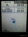
Proof. @52.6467,1.1956
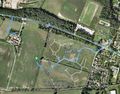
Google Earth Track


Achievements
Expeditions and Plans
| 2015-12-13 | ||
|---|---|---|
| St. Gallen, Switzerland | RecentlyChanged | in Kreuzlingen, Switzerland. Not far from the german border. |
| Mannheim, Germany | Q-Owl, Q-Owla | In a little vineyard between Monsheim and Mölsheim. |
| Norwich, United Kingdom | Sourcerer | In a field, soon to be a new housing estate, west of Costessey, Norwich, No... |
| Hamburg (East), Germany | GeorgDerReisende | The hash lay in the last remain of the Tonradsmoor in Hamburg-Volksdorf. |
| Arvidsjaur, Sweden | Draradech, Arne, Dr. P | Just north of Arvidsjaur, approx. 40m from the street. |
Sourcerer's Expedition Links
2015-12-12 52 1 - 2015-12-13 52 1 - 2015-12-14 52 1 - KML file download of Sourcerer's expeditions for use with Google Earth.