Difference between revisions of "2015-12-28 47 -122"
imported>Thomcat ([live picture]Creekside church [http://www.openstreetmap.org/?lat=47.79406860&lon=-122.32848140&zoom=16&layers=B000FTF @47.7941,-122.3285]) |
imported>FippeBot m (Location) |
||
| (One intermediate revision by one other user not shown) | |||
| Line 18: | Line 18: | ||
== Expedition == | == Expedition == | ||
| − | + | When one defines the route home from work as roughly A to B, a lot of geohash points can fit on that route line. This was a lovely one, just north of Lake Ballinger and on church property to boot (my third Holy Hash). | |
| + | |||
| + | Drove to the creek, snapped a picture, and parked before sunset. A minor amount of wandering got me to less than a meter from the spot, where I snapped more pictures and uploaded. Yay for the new geohashdroid app, still learning a few features though. | ||
| + | |||
| + | I did not leave a marker for others - no curb to scribble on and no environmentally friendly alternative. | ||
== Tracklog == | == Tracklog == | ||
| Line 45: | Line 49: | ||
| − | |||
| − | |||
| − | |||
[[Category:Expeditions]] | [[Category:Expeditions]] | ||
[[Category:Expeditions with photos]] | [[Category:Expeditions with photos]] | ||
[[Category:Coordinates reached]] | [[Category:Coordinates reached]] | ||
| − | + | {{location|US|WA|SN}} | |
| − | |||
| − | |||
| − | |||
| − | |||
| − | |||
| − | |||
| − | |||
| − | |||
| − | |||
| − | |||
Latest revision as of 06:17, 15 August 2019
| Mon 28 Dec 2015 in Seattle: 47.7939146, -122.3286676 geohashing.info google osm bing/os kml crox |
Location
A creek next to a church parking lot just north of Lake Ballinger.
Participants
Plans
Stop by after work, hopefully during daylight (sunset is at 4:24 pm)
Expedition
When one defines the route home from work as roughly A to B, a lot of geohash points can fit on that route line. This was a lovely one, just north of Lake Ballinger and on church property to boot (my third Holy Hash).
Drove to the creek, snapped a picture, and parked before sunset. A minor amount of wandering got me to less than a meter from the spot, where I snapped more pictures and uploaded. Yay for the new geohashdroid app, still learning a few features though.
I did not leave a marker for others - no curb to scribble on and no environmentally friendly alternative.
Tracklog
Photos
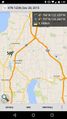
Hopefully the last screenshot I need for geohashing
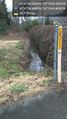
The creek @47.7936,-122.3291

geohasher @47.7939,-122.3287
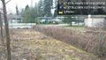
Creek from the other end @47.7939,-122.3287
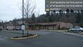
Creekside church @47.7941,-122.3285


