Difference between revisions of "2016-04-09 52 1"
From Geohashing
imported>Sourcerer m (→New expedition) |
imported>FippeBot m (Location) |
||
| Line 43: | Line 43: | ||
[[Category:Expeditions with photos]] | [[Category:Expeditions with photos]] | ||
[[Category:Coordinates reached]] | [[Category:Coordinates reached]] | ||
| + | {{location|GB|ENG|NFK}} | ||
Latest revision as of 00:09, 16 August 2019
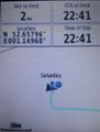
| Sat 9 Apr 2016 in Norwich, UK: 52.6579399, 1.1496916 geohashing.info google osm bing/os kml crox |
Location
A field north of the A47, just west of Norwich, Norfolk, UK.
Participants
Plans
One of two spanning midnight - 2016-04-09 52 1 - 2016-04-10 52 1 - ETA 22:50.
Expedition
This was easy enough. There was a deep ditch at the first parking place but at the second, after a short walk a field entrance was easily found. A short perimeter walk followed by tractor tracks led to the hashpoint. It was threatening to rain and the ground was quite wet. The temperature was 5.5C.
Photos
Proof
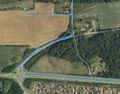
Google Earth Track


Achievements
Expeditions and Plans
| 2016-04-09 | ||
|---|---|---|
| Melbourne East, Australia | Kozz | A farm (private property) in the undulating hills at the back of Diamond Cr... |
| Norwich, United Kingdom | Sourcerer | A field north of the A47, just west of Norwich, Norfolk, UK. |
| Stockholm, Sweden | Cjk | In the woods near Gottröra, Sweden. |
Sourcerer's Expedition Links
2016-04-07 52 1 - 2016-04-09 52 1 - 2016-04-10 52 1 - KML file download of Sourcerer's expeditions for use with Google Earth.