Difference between revisions of "2008-05-29 47 -122"
From Geohashing
imported>Thomcat (Success/failure category added) |
imported>FippeBot m (Location) |
||
| (One intermediate revision by one other user not shown) | |||
| Line 11: | Line 11: | ||
This hash is located south of Issaquah in the [[Seattle, Washington|Seattle]] graticule. It is a rural road part way up Cedar Mountain. | This hash is located south of Issaquah in the [[Seattle, Washington|Seattle]] graticule. It is a rural road part way up Cedar Mountain. | ||
| + | |||
| + | == Participants == | ||
| + | *[[User:Thomcat|Thomcat]] | ||
==Expeditions== | ==Expeditions== | ||
| Line 27: | Line 30: | ||
[[Category:Expeditions with photos]] | [[Category:Expeditions with photos]] | ||
[[Category:Coordinates reached]] | [[Category:Coordinates reached]] | ||
| + | {{location|US|WA|KN}} | ||
Latest revision as of 04:24, 7 August 2019
| Thu 29 May 2008 in Seattle: 47.4647016, -122.0341244 geohashing.info google osm bing/os kml crox |
Contents
About
This hash is located south of Issaquah in the Seattle graticule. It is a rural road part way up Cedar Mountain.
Participants
Expeditions
Thomcat
Second geohash in a week, and 250 miles west of my last one. They were laying down gravel on a rural road, so I had to move the car. The hash point was in the bushes between the driveway and the road.
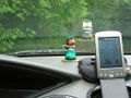
GPS fix, in Pacific Standard Time

The truck moves up the road while I pull into a driveway.

Thomcat makes his appearance.


