Difference between revisions of "2016-07-04 51 1"
imported>Sourcerer m (→Corrected graticule) |
imported>FippeBot m (Location) |
||
| (3 intermediate revisions by one other user not shown) | |||
| Line 17: | Line 17: | ||
== Plans == | == Plans == | ||
| − | + | Three of three spanning midnight - [[2016-07-03 52 1]] - [[2010-11-21 51 1|2010-11-21 51 1 Retro]] - [[2016-07-04 51 1]] - ETA 00:00. | |
Clambering over the roadside crash barrier might be close enough. A bum slide down the embankment might also be needed. The vegetation looks very dense. | Clambering over the roadside crash barrier might be close enough. A bum slide down the embankment might also be needed. The vegetation looks very dense. | ||
| Line 23: | Line 23: | ||
== Expedition == | == Expedition == | ||
| + | Just before midnight I parked in a lay-by on the main road. The hashpoint was 10 metres away down the embankment and not easy to reach. The vegetation was very dense at the woodland edge. I returned to the car and drove to a side road which crossed under the main road with a bridge. | ||
| + | There there was a mown path leading to the thicket with a black cat fleeing the light of my torch. A well trodden track led up the embankment. I heard movement and a human cough. I think there was a rough sleeper sheltering under the bridge or perhaps it was a lovers' tryst. I never saw anyone. | ||
| + | |||
| + | There was a 15 metre bushwhack on the 30 degree embankment to reach the hashpoint. I accidentally set off my camera flash - not the best plan if you're trying to be discrete. While taking my evidence photo someone flashed a torch in my direction. They were about 15 metres away close to the bridge blocking my return path. I guessed my activity was less illegal than the torch bearer's so I made my way towards the exit. Whoever it was melted into the darkness and I never saw anyone. A midnight mystery! | ||
== Photos == | == Photos == | ||
<gallery caption="Photo Gallery" widths="200px" heights="200px" perrow="3"> | <gallery caption="Photo Gallery" widths="200px" heights="200px" perrow="3"> | ||
| + | Image:2016-07-04 51 1 Sourcerer Proof 1.jpg | First attempt | ||
| + | Image:2016-07-04 51 1 Sourcerer Proof 2.jpg | Second attempt | ||
| + | Image:2016-07-04 51 1 Sourcerer Track.jpg | Google Earth Track | ||
</gallery> | </gallery> | ||
| Line 34: | Line 41: | ||
{{Midnight geohash | {{Midnight geohash | ||
| − | | latitude = | + | | latitude = 51 |
| longitude = 1 | | longitude = 1 | ||
| date = 2016-07-04 | | date = 2016-07-04 | ||
| Line 47: | Line 54: | ||
}} | }} | ||
| − | |||
| − | |||
[[Category:Expeditions]] | [[Category:Expeditions]] | ||
[[Category:Expeditions with photos]] | [[Category:Expeditions with photos]] | ||
[[Category:Coordinates reached]] | [[Category:Coordinates reached]] | ||
| − | + | {{location|GB|ENG|SFK}} | |
Latest revision as of 00:55, 16 August 2019
| Mon 4 Jul 2016 in Canterbury, UK: 51.9746437, 1.3409980 geohashing.info google osm bing/os kml crox |
Location
A roadside embankment in north Felixtowe, Suffolk, UK.
Participants
Plans
Three of three spanning midnight - 2016-07-03 52 1 - 2010-11-21 51 1 Retro - 2016-07-04 51 1 - ETA 00:00.
Clambering over the roadside crash barrier might be close enough. A bum slide down the embankment might also be needed. The vegetation looks very dense.
Expedition
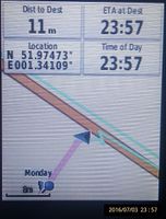
Just before midnight I parked in a lay-by on the main road. The hashpoint was 10 metres away down the embankment and not easy to reach. The vegetation was very dense at the woodland edge. I returned to the car and drove to a side road which crossed under the main road with a bridge.
There there was a mown path leading to the thicket with a black cat fleeing the light of my torch. A well trodden track led up the embankment. I heard movement and a human cough. I think there was a rough sleeper sheltering under the bridge or perhaps it was a lovers' tryst. I never saw anyone.
There was a 15 metre bushwhack on the 30 degree embankment to reach the hashpoint. I accidentally set off my camera flash - not the best plan if you're trying to be discrete. While taking my evidence photo someone flashed a torch in my direction. They were about 15 metres away close to the bridge blocking my return path. I guessed my activity was less illegal than the torch bearer's so I made my way towards the exit. Whoever it was melted into the darkness and I never saw anyone. A midnight mystery!
Photos
- Photo Gallery
First attempt

Second attempt

Google Earth Track


Achievements
Sourcerer earned the Midnight Geohash achievement
|
Expeditions and Plans
| 2016-07-04 | ||
|---|---|---|
| Williamsport, Pennsylvania | Pedalpusher | Off Locey Creek Rd in a field |
| Canterbury, United Kingdom | Sourcerer | A roadside embankment in north Felixtowe, Suffolk, UK. |
Sourcerer's Expedition Links
2016-07-03 52 1 - 2016-07-04 51 1 - 2016-07-05 52 1 - KML file download of Sourcerer's expeditions for use with Google Earth.