Difference between revisions of "2016-07-09 52 1"
From Geohashing
imported>Sourcerer m ([live picture] Arrived. [http://www.openstreetmap.org/?lat=52.36355960&lon=1.07772231&zoom=16&layers=B000FTF @52.3636,1.0777]) |
imported>Sourcerer m (→Achievements) |
||
| Line 40: | Line 40: | ||
}} | }} | ||
| − | |||
| − | |||
[[Category:Expeditions]] | [[Category:Expeditions]] | ||
[[Category:Expeditions with photos]] | [[Category:Expeditions with photos]] | ||
[[Category:Coordinates reached]] | [[Category:Coordinates reached]] | ||
| − | |||
Revision as of 23:06, 8 July 2016
| Sat 9 Jul 2016 in Norwich, UK: 52.3635402, 1.0775782 geohashing.info google osm bing/os kml crox |
Location
A field, close to a footpath, between Magpie Hill and Palgrave, Suffolk, UK.
Participants
Plans
Two of two spanning midnight - 2016-07-08 52 1 - 2016-07-09 52 1 - ETA 00:00.
Expedition
Photos
- Photo Gallery
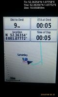
Arrived. @52.3636,1.0777

Achievements
Expeditions and Plans
| 2016-07-09 | ||
|---|---|---|
| Zürich, Switzerland | Someone went | In a field in Suhr, conveniently close to some roads |
| Erfurt, Germany | Manu, Reinhard, Pico | On a field between Effelder and Rückerswind, Thuringia, Germany. |
| Kassel, Germany | GeorgDerReisende | The hash lay in the forest east of the Twiste barrage. |
| Norwich, United Kingdom | Sourcerer | A field, close to a footpath, between Magpie Hill and Palgrave, Suffolk, UK... |
| Kiel, Germany | ZettS | Wolliner Weg in Kiel. |
Sourcerer's Expedition Links
2016-07-08 52 1 - 2016-07-09 52 1 - 2016-07-10 52 1 - KML file download of Sourcerer's expeditions for use with Google Earth.