Difference between revisions of "2016-07-17 52 1"
From Geohashing
imported>Sourcerer m (→New expedition) |
imported>FippeBot m (Location) |
||
| Line 43: | Line 43: | ||
[[Category:Expeditions with photos]] | [[Category:Expeditions with photos]] | ||
[[Category:Coordinates reached]] | [[Category:Coordinates reached]] | ||
| + | {{location|GB|ENG|NFK}} | ||
Latest revision as of 01:02, 16 August 2019
| Sun 17 Jul 2016 in Norwich, UK: 52.3657633, 1.2023706 geohashing.info google osm bing/os kml crox |
Location
A field perimeter north of the A143, between Billingford and Thorpe Abbotts, Norfolk, UK.
Participants
Plans
One of two spanning midnight - 2016-07-17 52 1 - 2016-07-18 52 1 - ETA 23:40.
Expedition
Parking in and leaving the field entrance was a bit scary. Unusually there was a lot of traffic, possibly from the Latitude Festival of Arts and Music. The walk to the hashpoint was easy enough in a wheat field with well defined tractor tracks.
Photos
- Photo Gallery
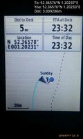
Arrived. @52.3658,1.2023
Achievements
Expeditions and Plans
| 2016-07-17 | ||
|---|---|---|
| Norwich, United Kingdom | Sourcerer | A field perimeter north of the A143, between Billingford and Thorpe Abbotts... |
Sourcerer's Expedition Links
2016-07-16 52 1 - 2016-07-17 52 1 - 2016-07-18 52 1 - KML file download of Sourcerer's expeditions for use with Google Earth.

