Difference between revisions of "2016-07-22 47 -4"
From Geohashing
imported>Benjw (no longer a new report) |
imported>FippeBot m (Location) |
||
| Line 79: | Line 79: | ||
[[Category:Expeditions with photos]] | [[Category:Expeditions with photos]] | ||
[[Category:Coordinates reached]] | [[Category:Coordinates reached]] | ||
| + | {{location|FR|29}} | ||
Revision as of 02:02, 7 August 2019
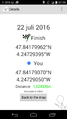
| Fri 22 Jul 2016 in 47,-4: 47.8417996, -4.2472939 geohashing.info google osm bing/os kml crox |
Location
A field in Kernel
Participants
Plans
See how close I'll get
Expedition
No problems at all. Few km drive from my holiday gite, I was at the road along the field at approx 8AM. Crop recently harvested, no impediments to walk up to the spot, wander around, take the pictures and leave back home.
The town that the filed belongs to is called Kernel. The Bretons call their small villages Ker with an extension that actually names the said place. In this case nel, which together makes a nice name to issue a Tale of 2 hashes, so I issue one.
Tracklog
Photos
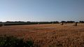
Out of the car: clear view to the hash
There you go
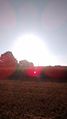
Sun in the east
and Moon in the west

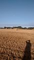
View in the hasher's direction


Achievements

JwB issued a challenge for the Tale of Two Hashes achievement
by geohashing in a place named Kernel from the (47, -4) geohash on 2016-07-22.
