Difference between revisions of "2016-09-13 50 6"
imported>DODO (→Location) |
imported>FippeBot m (Location) |
||
| (9 intermediate revisions by one other user not shown) | |||
| Line 25: | Line 25: | ||
<!-- who attended: If you link to your wiki user name in this section, your expedition will be picked up by the various statistics generated for geohashing. You may use three tildes ~ as a shortcut to automatically insert the user signature of the account you are editing with. | <!-- who attended: If you link to your wiki user name in this section, your expedition will be picked up by the various statistics generated for geohashing. You may use three tildes ~ as a shortcut to automatically insert the user signature of the account you are editing with. | ||
--> | --> | ||
| + | [[User:DODO|DODO]] | ||
== Plans == | == Plans == | ||
<!-- what were the original plans --> | <!-- what were the original plans --> | ||
| + | After the trip to Belgium [[2016-09-12_50_6|yesterday]] I had to get close enough to my home, that I can reach it in a single day. So I decided to go south and return to Germany. Unfortunately the hash was to far from any railway station, so I couldn't reach one today. The closest town was Prüm, so I decided to go there and get surprised how I will get home tomorrow. | ||
== Expedition == | == Expedition == | ||
| − | + | Well, there were 400 m of height that I could come down from the hash to Eupen yesterday. And it is clear what that means for today. Right, first of all I have to climb 400 meters. That did cost me almost exactly 2 hours. On the top I reached a big Venn area, so I had a break and took some pictures. 20 minutes later I reached the Vennbahn, another former railway track that had been turned into a cycle path. This time I just stayed on the track, when komoot told me not to, because I knew that it would lead me back there anyway. So I needed one and a half hour for the next 28 Kilometers. Then I've reached St. Vith and decided to have a break there. First I ate some cakes that I've bought in Eupen and then I had a delicious belgian beer. From here my path goes down to the valley of the Our, a rivulet that is the border between Belgium and Germany. I realized that fact when I suddenly came along a german sign. I must have crossed the border, but where? I turned back and came soon to the river that I've just crossed. There was an overgrown boundary-post. Yes, that must've been the border. | |
| + | |||
| + | I had to climb another hill before I came close to the hash and I was really tired. There was a bench where I left my bike. The hash was on a harvested field, easy to reach. I wanted to make a break on the bench but it was in the sun and it was much to hot to feel comfortable. So I continued my ride. Soon I reached a very steep downhill and came out on another former railway track. The Eifel seems to be a paradise for biking (if you don't have to reach random points on hills). Prüm is a very small town with a very large cathedral. It was founded by the father of Charlemagne. | ||
== Tracklog == | == Tracklog == | ||
| − | + | [https://www.komoot.de/tour/12343580 101 KM by bike] | |
== Photos == | == Photos == | ||
| − | |||
| − | |||
| − | |||
<gallery perrow="5"> | <gallery perrow="5"> | ||
| + | Image:2016-09-13 50 6-00.jpg|large Venn (hill moor) | ||
| + | Image:2016-09-13 50 6-01.jpg|border (the boundary post is on the left side of the picture) | ||
| + | Image:2016-09-13 50 6 09.png|proof | ||
| + | Image:2016-09-13 50 6-02.jpg|proof of transport | ||
| + | Image:2016-09-13 50 6-03.jpg|west | ||
| + | Image:2016-09-13 50 6-04.jpg|south | ||
| + | Image:2016-09-13 50 6-05.jpg|east | ||
| + | Image:2016-09-13 50 6-06.jpg|north | ||
| + | Image:2016-09-13 50 6-07.jpg|hasher | ||
| + | Image:2016-09-13 50 6-08.jpg|cathedral in Prüm | ||
</gallery> | </gallery> | ||
| Line 46: | Line 57: | ||
<!-- Add any achievement ribbons you earned below, or remove this section --> | <!-- Add any achievement ribbons you earned below, or remove this section --> | ||
| − | |||
| − | |||
| − | |||
| − | + | {{land geohash | |
| + | | latitude = 50 | ||
| + | | longitude = 6 | ||
| + | | date = 2016-09-13 | ||
| + | | name = DODO | ||
| + | }} | ||
| − | + | {{bicycle geohash | |
| − | + | | latitude = 50 | |
| − | + | | longitude = 6 | |
| − | + | | date = 2016-09-13 | |
| + | | name = DODO | ||
| + | | distance = 101 KM | ||
| + | }} | ||
| − | + | {{consecutive geohash | |
| + | | count = 3 | ||
| + | | latitude = 50 | ||
| + | | longitude = 6 | ||
| + | | date = 2016-09-11 | ||
| + | | name = DODO | ||
| + | }} | ||
| + | |||
| + | {{Border geohash achievement | ||
| + | | latitude = 50 | ||
| + | | longitude = 6 | ||
| + | | date = 2016-09-13 | ||
| + | | country1 = Belgium | ||
| + | | country2 = Germany | ||
| + | | name = DODO | ||
| + | }} | ||
| − | |||
[[Category:Expeditions]] | [[Category:Expeditions]] | ||
| − | |||
| − | |||
| − | |||
| − | |||
| − | |||
| − | |||
| − | |||
[[Category:Coordinates reached]] | [[Category:Coordinates reached]] | ||
| − | + | {{location|DE|RP|BIT}} | |
| − | |||
| − | |||
| − | |||
| − | |||
| − | |||
| − | |||
| − | |||
| − | |||
| − | |||
| − | |||
| − | |||
| − | |||
| − | |||
| − | |||
| − | |||
| − | |||
| − | |||
Latest revision as of 02:10, 7 August 2019
| Tue 13 Sep 2016 in 50,6: 50.1875814, 6.2198325 geohashing.info google osm bing/os kml crox |
Location
A field near Heckhuscheid (Eifel).
Participants
Plans
After the trip to Belgium yesterday I had to get close enough to my home, that I can reach it in a single day. So I decided to go south and return to Germany. Unfortunately the hash was to far from any railway station, so I couldn't reach one today. The closest town was Prüm, so I decided to go there and get surprised how I will get home tomorrow.
Expedition
Well, there were 400 m of height that I could come down from the hash to Eupen yesterday. And it is clear what that means for today. Right, first of all I have to climb 400 meters. That did cost me almost exactly 2 hours. On the top I reached a big Venn area, so I had a break and took some pictures. 20 minutes later I reached the Vennbahn, another former railway track that had been turned into a cycle path. This time I just stayed on the track, when komoot told me not to, because I knew that it would lead me back there anyway. So I needed one and a half hour for the next 28 Kilometers. Then I've reached St. Vith and decided to have a break there. First I ate some cakes that I've bought in Eupen and then I had a delicious belgian beer. From here my path goes down to the valley of the Our, a rivulet that is the border between Belgium and Germany. I realized that fact when I suddenly came along a german sign. I must have crossed the border, but where? I turned back and came soon to the river that I've just crossed. There was an overgrown boundary-post. Yes, that must've been the border.
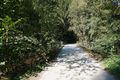
I had to climb another hill before I came close to the hash and I was really tired. There was a bench where I left my bike. The hash was on a harvested field, easy to reach. I wanted to make a break on the bench but it was in the sun and it was much to hot to feel comfortable. So I continued my ride. Soon I reached a very steep downhill and came out on another former railway track. The Eifel seems to be a paradise for biking (if you don't have to reach random points on hills). Prüm is a very small town with a very large cathedral. It was founded by the father of Charlemagne.
Tracklog
Photos
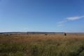
large Venn (hill moor)
border (the boundary post is on the left side of the picture)
proof
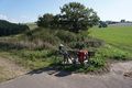
proof of transport
west
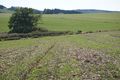
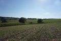
south
east
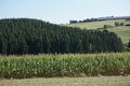
north

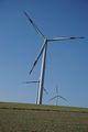
hasher
- Error creating thumbnail: Unable to save thumbnail to destination
cathedral in Prüm


Achievements
DODO earned the Land geohash achievement
|
DODO earned the Bicycle geohash achievement
|
DODO earned the Consecutive geohash achievement
|
DODO earned the Border geohash achievement
|