Difference between revisions of "2016-09-25 49 9"
imported>DODO (→Expedition) |
imported>FippeBot m (Location) |
||
| (4 intermediate revisions by one other user not shown) | |||
| Line 41: | Line 41: | ||
== Tracklog == | == Tracklog == | ||
<!-- if your GPS device keeps a log, you may post a link here --> | <!-- if your GPS device keeps a log, you may post a link here --> | ||
| + | [https://www.komoot.de/tour/12652117 140 KM bull riding] and additional 100 KM by train | ||
== Photos == | == Photos == | ||
| Line 47: | Line 48: | ||
--> | --> | ||
<gallery perrow="5"> | <gallery perrow="5"> | ||
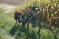
| + | Image: 2016-09-25 49 9-00.jpg|a coach near my path | ||
| + | Image: 2016-09-25 49 9-01.jpg|strengthening | ||
| + | Image: 2016-09-25 49 9-02.jpg|autumn crocus and | ||
| + | Image: 2016-09-25 49 9-03.jpg|... mint | ||
| + | Image: 2016-09-25 49 9-04.jpg|the Neckar and the nuclear power plant (I've already seen one in Philippsburg today) | ||
| + | Image: 2016-09-25 49 9-05.jpg|the NSU-street (NSU is a former german auto brand, now overtaken by Audi) | ||
| + | Image: 2016-09-25 49 9-06.jpg|paraglider near the hash | ||
| + | Image: 2016-09-25 49 9-07.jpg|bull | ||
| + | Image: 2016-09-25 49 9-12.png|proof | ||
| + | Image: 2016-09-25 49 9-08.jpg|view from the hash to the greenland | ||
| + | Image: 2016-09-25 49 9-09.jpg|and into the corn field (pretty much the same in three directions | ||
| + | Image: 2016-09-25 49 9-10.jpg|hash swan | ||
| + | Image: 2016-09-25 49 9-11.jpg|starting area for paragliders | ||
</gallery> | </gallery> | ||
| Line 53: | Line 67: | ||
<!-- Add any achievement ribbons you earned below, or remove this section --> | <!-- Add any achievement ribbons you earned below, or remove this section --> | ||
| − | + | {{land geohash | |
| − | + | | latitude = 49 | |
| − | + | | longitude = 9 | |
| + | | date = 2016-09-25 | ||
| + | | name = DODO | ||
| + | }} | ||
| − | |||
| − | + | {{Multihash | |
| − | + | | latitude1 = 49 | |
| − | + | | longitude1 = 8 | |
| − | -- | + | | latitude2 = 49 |
| − | + | | longitude2 = 9 | |
| − | + | | date = 2016-09-25 | |
| + | | name = DODO | ||
| + | }} | ||
| − | |||
[[Category:Expeditions]] | [[Category:Expeditions]] | ||
| − | |||
| − | |||
| − | |||
| − | |||
| − | |||
| − | |||
| − | |||
[[Category:Coordinates reached]] | [[Category:Coordinates reached]] | ||
| − | + | {{location|DE|BW|ÖHR}} | |
| − | |||
| − | |||
| − | |||
| − | |||
| − | |||
| − | |||
| − | |||
| − | |||
| − | |||
| − | |||
| − | |||
| − | |||
| − | |||
| − | |||
| − | |||
| − | |||
| − | |||
Latest revision as of 01:31, 16 August 2019
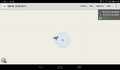
| Sun 25 Sep 2016 in 49,9: 49.2475990, 9.4175408 geohashing.info google osm bing/os kml crox |
Location
A corn field at the Kocher near Möglingen
Participants
Plans
Second part of my multi-hash trial on my bull. For the plans see my other report.
Expedition
After my first success I continued the ride. I quickly passed Philippsburg and Wiesental and had some kilometers of forest after that. Than I reached the Kraichgau and the relief wasn't all flat anymore (but the Kraichgau is the region that links the two mountain ranges Odenwald and Schwarzwald and has relative low hills). After a total of 80 kilometers I reached the town Schaigern and passed an ice cream parlor - well, to be honest, I didn't pass it but made a break. So boosted, I continued my way with new power. I now followed the valley of the Leimbach and soon I reached the river Neckar near the nuclear power plant of Neckarwestheim. I followed the river to Neckarsulm where I saw the plant of Audi. Then I left the river, crossed a low hill and reached the rivulet Kocher. 10 kilometers (and two crossings of the Kocher) further I had reached the hash area.
I could park the bull 15 m from the hash. A path continued between a green land and a corn field. I hoped for the green land, but twelve meters farther I was disabused. 5 meters into the corn field. I entered it for 3 meters and reached the circle of insecurity. I decided this to be good enough as it didn't make sense to harm more plants than necessary (although I walked into the field without harming any plants). After that I walked along the field and reached the Kocher, where a hash swan already waited for me. Close to the hash was a paraglider trying an air hash. I continued my way, crossed the Kocher again and found the starting area for the paragliders. This time I followed the Kocher down to its mouth in Bad Frciedrichshall. I rode to the station, bought a ticket and ... had still half an hour. Time enough for a beer in the beer garden that I had passed 800m ago :-)
Two trains (change in Mannheim) brought me back to Speyer in one and a half hour and I reached home at 6 o'clock again.
Tracklog
140 KM bull riding and additional 100 KM by train
Photos
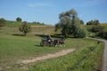
a coach near my path
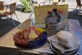
strengthening
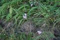
autumn crocus and
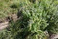
... mint
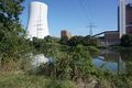
the Neckar and the nuclear power plant (I've already seen one in Philippsburg today)
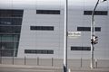
the NSU-street (NSU is a former german auto brand, now overtaken by Audi)
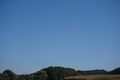
paraglider near the hash
bull
proof
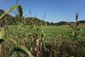
view from the hash to the greenland
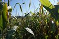
and into the corn field (pretty much the same in three directions
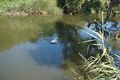
hash swan
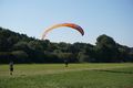
starting area for paragliders


Achievements
DODO earned the Land geohash achievement
|
DODO earned the Multihash Achievement
|