Difference between revisions of "2016-12-30 42 -78"
imported>Pedalpusher (summary, ribbons added) |
imported>Pedalpusher (added pictures) |
||
| Line 18: | Line 18: | ||
On the way back, I was again able to stay out of the water and found my way back to the cemetery without too much trouble. I took a picture of the Seneca Nations Convention Center signage but unfortunately, it said the temp was 32 degrees. My phone's weather report had the area at a high of 30 degrees as well as another bank sign down the road. With the disparity in readings, without an actual thermometer, I won't take the Frozen geohash for this expedition even though I think it was. | On the way back, I was again able to stay out of the water and found my way back to the cemetery without too much trouble. I took a picture of the Seneca Nations Convention Center signage but unfortunately, it said the temp was 32 degrees. My phone's weather report had the area at a high of 30 degrees as well as another bank sign down the road. With the disparity in readings, without an actual thermometer, I won't take the Frozen geohash for this expedition even though I think it was. | ||
| + | |||
| + | Note on this expedition: Technically, the Seneca Nation of Indians is sovereign territory and while there is no Border patrol, it should count as a Border Crossing. | ||
== Photos == | == Photos == | ||
| − | <gallery perrow=" | + | <gallery perrow="6"> |
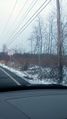
| − | Image: | + | Image: 2016-12-30 clouds.jpg | On my drive down, I was a little concerned about heavy lake effect snow. |
| − | Image: | + | Image: 2016-12-30 SenecaBorder.jpg | Crossing into Seneca Nation Territory. There was no one on the road behind me so I stopped to take a picture. |
| − | Image: | + | Image: 2016-12-30 cemetery.jpg | Walking in, a view of the dark clouds and the cemetery in which I parked. |
| − | Image: | + | Image: 2016-12-30 dam.jpg | A view of the dam that was providing a nice pond for the cemetery. |
| − | Image: | + | Image: 2016-12-30 onIsland.jpg | Getting down to the creek, I crossed the small section and am heading toward the hash on the mini Island. |
| − | Image: | + | Image: 2016-12-30 eagle.jpg | My first good view of the main creek, a Bald Eagle was flying by. This was the best shot I got. |
| − | Image: | + | Image: 2016-12-30 mainCreek.jpg | Before heading downhill, a view of the main Creek. |
| − | Image: | + | Image: 2016-12-30 gps.jpg | Made it! |
| + | Image: 2016-12-30 gps2.jpg | Accuracy. | ||
| + | Image: 2016-12-30 stupidGrin.jpg | Standard Stupid Grin. | ||
| + | Image: 2016-12-30 SenecaSign.jpg | On the way out, I took a picture of the Signage for the Seneca Nation's Convention center across the street. | ||
</gallery> | </gallery> | ||
| Line 43: | Line 48: | ||
| name = Pedalpusher | | name = Pedalpusher | ||
| place = Seneca Nation | | place = Seneca Nation | ||
| + | }} | ||
| + | {{Border geohash achievement | ||
| + | | latitude = 42 | ||
| + | | longitude = -78 | ||
| + | | date = 2016-12-30 | ||
| + | | name = Pedalpusher | ||
| + | | country1 = USA | ||
| + | | country2 = Seneca Nation of Indians | ||
}} | }} | ||
| − | |||
[[Category:Expeditions]] | [[Category:Expeditions]] | ||
[[Category:Coordinates reached]] | [[Category:Coordinates reached]] | ||
| − | + | [[Category:Expeditions with photos]] | |
Revision as of 18:33, 7 January 2017
| Fri 30 Dec 2016 in 42,-78: 42.5320265, -78.9938169 geohashing.info google osm bing/os kml crox |
Contents
[hide]Location
Next to Cattaraugus Creek near the central area of the Seneca Indian Reservation
Participants
Plans
Looking at this when the hashes first came out, I didn't think this was accessible, but taking a second look, I saw there is a cemetery just north of the hash which can give me access. The hash, being right next to Cattaraugus creek however, may prove difficult and depending on how high the waters are, I may not be able to get there, but I'll try. I have a doc appointment this afternoon so I'll drive down after that. If successful, I'll also issue a Tale of Two Challenge for Seneca Nation. The rest of the weekend hashes also look good so I'm hoping this will be the first in a good consecutive hash string. Tomorrow's hash expedition can be found here.
Expedition
After the doc visit, I drove south on Rt 20 passing at least one hash I've done in the past. On the drive down, I was a little concerned because the clouds in that direction were dark and the news spoke of snowfall at 1-2 inches per hour. For those in warmer climates, that is really heavy snow and if it's windy, can lead to white-out conditions. Fortunately, I turned to go east before getting to the current lake effect snow bands at the time. I found the cemetery and ended up parking on one of the cemetery roads rather than stick out into the main road trying to park on the shoulder.
I made my way down the cemetery road toward the creek and found an ATV trail leading off into the woods which is what I saw on the satellite pictures. Getting closer to the creek, the trail split and going more toward the hash, that trail was covered in thin ice and large areas of water so I chose to head first to the creek and then try to make my way to the hash. In this area, the creek had split around some land that was slightly higher and kind of made an island, but the creek on this side was very shallow and went through more swampy land than actual creek. I was able to stay on large sticks and tufts of grass and kept my feet dry as I made my way to higher ground.
The brush was thick, but I was able to push through relatively easily and before zeroing in on the hash, I was treated to a very nice view of the very large creek. As I admired the view, I saw a Bald Eagle flying by on the other side of the creek. Trying to quickly get out my phone to take a picture, I fumbled with my gloves and by the time I was able to get a shot, the bird had flown far enough that the camera just picked up a tiny little blob. Oh, well. I then proceeded to the hash, and danced around enough to get a decent reading and some pictures.
On the way back, I was again able to stay out of the water and found my way back to the cemetery without too much trouble. I took a picture of the Seneca Nations Convention Center signage but unfortunately, it said the temp was 32 degrees. My phone's weather report had the area at a high of 30 degrees as well as another bank sign down the road. With the disparity in readings, without an actual thermometer, I won't take the Frozen geohash for this expedition even though I think it was.
Note on this expedition: Technically, the Seneca Nation of Indians is sovereign territory and while there is no Border patrol, it should count as a Border Crossing.
Photos

On my drive down, I was a little concerned about heavy lake effect snow.
Crossing into Seneca Nation Territory. There was no one on the road behind me so I stopped to take a picture.
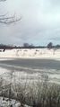
Walking in, a view of the dark clouds and the cemetery in which I parked.
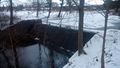
A view of the dam that was providing a nice pond for the cemetery.
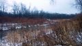
Getting down to the creek, I crossed the small section and am heading toward the hash on the mini Island.
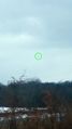
My first good view of the main creek, a Bald Eagle was flying by. This was the best shot I got.
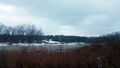
Before heading downhill, a view of the main Creek.
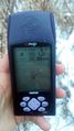
Made it!
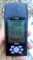
Accuracy.

Standard Stupid Grin.
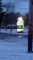
On the way out, I took a picture of the Signage for the Seneca Nation's Convention center across the street.


Ribbons
This user earned the Land geohash achievement
|
Pedalpusher issued a challenge for the Tale of Two Hashes achievement
|
Pedalpusher earned the Border geohash achievement
|