2016-12-31 42 -78
| Sat 31 Dec 2016 in 42,-78: 42.1014338, -78.4896370 geohashing.info google osm bing/os kml crox |
Contents
[hide]Location
In the town of Allegany, between I-86 and the Allegany Cemetery
Participants
- Pedalpusher
- Simon the dog
- Myka the dog
Plans
Yesterdays expedition will either be is the first in a consecutive hash or this will hopefully be the start of a new consecutive hash. Tomorrow's expedition report can be found here. This hash lands just North of the Allegany Cemetery and a little further North of a previous expedition near St. Bonaventure University and their cemetery. I'll try to aim for an Official Saturday Meetup. The hash area looks like it's unused land with some ATV tracks crisscrossing through it. I'll walk the dogs around there after we hit the hashpoint with the remaining light we'll have. I may get there a little earlier to have some extra walking around time with the dogs.
Expedition
I ended up leaving a little bit later than I planned when a friend stopped by to visit for a while. On the road, we made decent time, but hit some heavy snow and some traffic by Ellicottville. It's a nice little town very close to some ski slopes so it gets crowded in the winter-time. Further south of E-ville, the snow stopped and we had a clear drive the rest of the way. Getting to Allegany, I missed my turn because the first intersection(the one I needed) was missing it's signage. Figuring it out and turning around, I found the cemetery but was surprised as the school I was expecting was actually across the street and the building that I though was the school, was the bus depot. I turned around in the school entrance and parked behind the bus depot. I originally thought this was the school because in the back, was a football(American) field.
Hopping out, we started walking along the fence dividing the field from the cemetery but I quickly realized I should have gone into the cemetery instead. Usually, cemeteries are totally fenced in and looking at the satellite pictures, it looked like the back of the field wasn't and the cemetery was. I found exactly the opposite, but we walked around the back of the field anyway just in case there was an opening. Not finding anything, we walked back to the road and entered the cemetery. Getting to the back, we found a way down the steep hill to the power lines and where the ATV tracks were. Following one to the hash, I didn't have much of a dance to do as the hash was right next to the trail.
Getting my pictures, we headed back to the field where we did another lap around the perimeter in the fading light to get the dogs a little extra exercise before heading for home.
While I was a bit late, I'm still going to call this an Official Saturday Meetup. I forgot to grab a screenshot on my phone of the time, but there are time-stamps in the metadata of the photos.
Photos
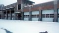
We parked by the School Bus Depot, it's hard to see, but there are buses behind the windows.
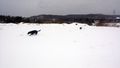
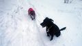
Getting behind the cemetery, the dogs were having a blast. I-86 is in the background.
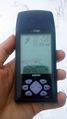
Made it.
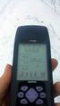
Accuracy.
The dogs sitting nicely at the hash. Myka is chewing on a stick.
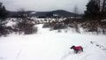
View from the hash, a look towards I-86.

Standard Stupid Grin.


Ribbons
This user earned the Land geohash achievement
|
Pedalpusher earned the xkcd Nullaturion achievement
|
Pedalpusher earned the Consecutive geohash achievement
|