Difference between revisions of "2017-01-19 52 5"
From Geohashing
imported>JwB m (→Expedition) |
imported>FippeBot m (Location) |
||
| (3 intermediate revisions by one other user not shown) | |||
| Line 36: | Line 36: | ||
== Photos == | == Photos == | ||
| − | + | ||
| − | |||
| − | |||
<gallery perrow="5"> | <gallery perrow="5"> | ||
| + | Image: 170119view.jpg | view to south | ||
| + | Image: 170119shadow.jpg | either us our shadows across the hash | ||
</gallery> | </gallery> | ||
== Achievements == | == Achievements == | ||
| − | |||
| − | |||
| − | |||
| − | |||
| − | |||
| − | |||
| − | |||
| − | |||
| − | |||
| − | |||
| − | |||
| − | |||
| − | |||
| − | |||
| − | |||
| − | |||
[[Category:Expeditions]] | [[Category:Expeditions]] | ||
| − | |||
[[Category:Expeditions with photos]] | [[Category:Expeditions with photos]] | ||
| − | [[Category: | + | [[Category:Coordinates reached]] |
[[Category:Expedition without GPS]] | [[Category:Expedition without GPS]] | ||
| − | + | {{location|NL|UT}} | |
| − | |||
| − | |||
| − | |||
| − | |||
| − | |||
| − | |||
| − | |||
| − | |||
| − | |||
| − | |||
| − | |||
| − | |||
| − | |||
| − | |||
| − | |||
| − | |||
| − | |||
| − | |||
| − | |||
| − | |||
| − | |||
Latest revision as of 02:01, 16 August 2019
| Thu 19 Jan 2017 in 52,5: 52.0383966, 5.0569543 geohashing.info google osm bing/os kml crox |
Location
A cycling track made on an old garbage dump
Participants
Plans
Had to go to Utrecht anyway, so a drive by and see how accessible it turns out to be
Expedition
Went to townb with my wife, and we wanted to go for a stroll anyway. Fortunately I studied the map before departure, cause upon arrival it turned out that I forgot my phone. It was beautiful whether, slightly (3 degrees?) below zero. The spot was on a bike training course that is constructed on top of an old garbage dump. The terrain was fully accessible and so we zig-zagged a bit across the terrain, so that we must have hit the spot, or at least have been within GPS accuracy of the exact spot.
Tracklog
Photos
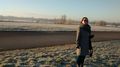
view to south
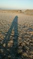
either us our shadows across the hash

