Difference between revisions of "2017-03-15 52 1"
From Geohashing
imported>Sourcerer (An expedition message sent via Geohash Droid for Android.) |
imported>FippeBot m (Location) |
||
| (2 intermediate revisions by one other user not shown) | |||
| Line 1: | Line 1: | ||
| − | + | {{meetup graticule | |
| − | |||
| − | |||
| − | |||
| − | |||
| − | |||
| − | |||
| − | |||
| − | |||
| − | |||
| − | {{meetup graticule | ||
| lat=52 | | lat=52 | ||
| lon=1 | | lon=1 | ||
| date=2017-03-15 | | date=2017-03-15 | ||
| + | | graticule_name=Norwich, UK | ||
| + | | graticule_link=Norwich, United Kingdom | ||
}} | }} | ||
| − | |||
| − | |||
__NOTOC__ | __NOTOC__ | ||
| + | == Location == | ||
| − | + | A field between St. Margaret and St. James, South Elmham, Suffolk, UK. | |
| − | |||
== Participants == | == Participants == | ||
| − | + | ||
| − | + | [[User:Sourcerer|Sourcerer]] | |
== Plans == | == Plans == | ||
| − | + | ||
| + | One of two spanning midnight - [[2017-03-15 52 1]] - [[2017-03-16 52 1]] - ETA 23:10. | ||
== Expedition == | == Expedition == | ||
| − | |||
| − | + | There was roadside parking and a public footpath. The hashpoint was about 20 metres off the path in a rape-seed field. There was a propane explosive bird scare machine lurking about 15 metres from the hashpoint. There was a dull red glow from the LED power indicator. At night the gun-shot sounds stop. | |
| − | |||
| − | == Photos == | + | == Photos == |
| − | < | + | <gallery caption="Gallery" widths="200px" heights="200px" perrow="3"> |
| − | Image: | + | Image:2017-03-15_52_1_Sourcerer_1489620183881.jpg | Arrived. [http://www.openstreetmap.org/?lat=52.39156187&lon=1.39544070&zoom=16&layers=B000FTF @52.3916,1.3954] |
| − | -- | + | Image:2017-03-15_52_1_Sourcerer.jpg | Google Earth Track. |
| − | |||
</gallery> | </gallery> | ||
== Achievements == | == Achievements == | ||
{{#vardefine:ribbonwidth|800px}} | {{#vardefine:ribbonwidth|800px}} | ||
| − | |||
| − | + | {{Sourcerer_links | |
| − | + | | prev = 2017-03-07 52 1 | |
| − | + | | curr = 2017-03-15 52 1 | |
| − | + | | next = 2017-03-16 52 1 | |
| − | + | | date = 2017-03-15 | |
| − | + | }} | |
| − | |||
| − | |||
| − | |||
| − | -- | ||
| − | |||
| − | |||
| − | |||
[[Category:Expeditions]] | [[Category:Expeditions]] | ||
| − | |||
[[Category:Expeditions with photos]] | [[Category:Expeditions with photos]] | ||
| − | |||
| − | |||
| − | |||
| − | |||
| − | |||
[[Category:Coordinates reached]] | [[Category:Coordinates reached]] | ||
| − | + | {{location|GB|ENG|SFK}} | |
| − | |||
| − | |||
| − | |||
| − | |||
| − | |||
| − | |||
| − | |||
| − | |||
| − | |||
| − | |||
| − | |||
| − | |||
| − | |||
| − | |||
| − | |||
| − | |||
| − | |||
Latest revision as of 02:15, 16 August 2019
| Wed 15 Mar 2017 in Norwich, UK: 52.3915635, 1.3954586 geohashing.info google osm bing/os kml crox |
Location
A field between St. Margaret and St. James, South Elmham, Suffolk, UK.
Participants
Plans
One of two spanning midnight - 2017-03-15 52 1 - 2017-03-16 52 1 - ETA 23:10.
Expedition
There was roadside parking and a public footpath. The hashpoint was about 20 metres off the path in a rape-seed field. There was a propane explosive bird scare machine lurking about 15 metres from the hashpoint. There was a dull red glow from the LED power indicator. At night the gun-shot sounds stop.
Photos
- Gallery
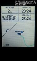
Arrived. @52.3916,1.3954
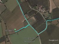
Google Earth Track.


Achievements
Expeditions and Plans
| 2017-03-15 | ||
|---|---|---|
| Victoria, British Columbia | Wijnland | In front of Esquimalt Harbour, between Fishgard lighthouse and Brothers Isl... |
| Mannheim, Germany | DODO | In a nurserynext to Schifferstadt |
| Kassel, Germany | GeorgDerReisende | The hash lay in the forest south of Calden. |
| Norwich, United Kingdom | Sourcerer | A field between St. Margaret and St. James, South Elmham, Suffolk, UK. |
| Utrecht, Netherlands | JwB | A field near Almere, almost no deviation from my commute needed. |
Sourcerer's Expedition Links
2017-03-07 52 1 - 2017-03-15 52 1 - 2017-03-16 52 1 - KML file download of Sourcerer's expeditions for use with Google Earth.