Difference between revisions of "2017-04-25 50 19"
imported>Malgond (→Expedition) |
imported>FippeBot m (Location) |
||
| (22 intermediate revisions by one other user not shown) | |||
| Line 1: | Line 1: | ||
| − | |||
| − | |||
| − | |||
| − | |||
| − | |||
| − | |||
| − | |||
| − | |||
| − | |||
| − | |||
{{meetup graticule | {{meetup graticule | ||
| lat=50 | | lat=50 | ||
| Line 14: | Line 4: | ||
| date=2017-04-25 | | date=2017-04-25 | ||
}} | }} | ||
| − | |||
| − | |||
__NOTOC__ | __NOTOC__ | ||
| − | |||
== Location == | == Location == | ||
| Line 23: | Line 10: | ||
== Participants == | == Participants == | ||
| − | + | ||
| − | + | [[User:Malgond|Malgond]] alone. | |
== Plans == | == Plans == | ||
| + | [[User:Malgond|Malgond]] plans to go. It's just 220 meters off his daily commute to work! | ||
| − | [[ | + | {| |
| + | |- | ||
| + | ! style="width:200px" | !! style="width:20px" | !! style="width:200px" | !! style="width:20px" | !! style="width:200px" | | ||
| + | |- | ||
| + | | [[Image:2017-04-25_50-19_p1.png|200px]] || || style="vertical-align: bottom" | [[Image:2017-04-25_50-19_p2.png|200px]] || || style="vertical-align: bottom" | [[Image:2017-04-25_50-19_p3.png|200px]] | ||
| + | |- | ||
| + | | style="vertical-align:top" | Planned detour from my daily commute routine. || || style="vertical-align: top" | The point is on the street next to the second parking spot. || || style="vertical-align: top" |This is how it looks in 3D view... | ||
| + | |- | ||
| + | | style="height:20px" | | ||
| + | |- | ||
| + | | colspan="3" | [[Image:2017-04-25_50-19_p4.png|420px]] || || ...and in street view. | ||
| + | |} | ||
== Expedition == | == Expedition == | ||
I haven't ventured for a geohashing expedition for a long time already, therefore I could not miss such an opportunity. According to Google Maps, the hash was located on a residential street very close to the road I drive to work every day. | I haven't ventured for a geohashing expedition for a long time already, therefore I could not miss such an opportunity. According to Google Maps, the hash was located on a residential street very close to the road I drive to work every day. | ||
| − | |||
The expedition itself was trivial. On my way to work I had turned right on an intersection I usually travel straight through and after negotiating another few turns and driving along narrow residential streets I have arrived at the spot. Because it was on the pavement, I wanted to drive right through it to get a rather mediocre version of speed racer achievement - the legal speed there is only 30 km/h. I was alone in the car this time snd had no tripod or holder therefore documenting that feat proved difficult and not particularly safe: I was trying to hold the camera straight while steering with the other hand. A few attempts to drive along the hashpoint failed or produced unsatisfactory results. I have parked the car nearby and get out to get some still shots. | The expedition itself was trivial. On my way to work I had turned right on an intersection I usually travel straight through and after negotiating another few turns and driving along narrow residential streets I have arrived at the spot. Because it was on the pavement, I wanted to drive right through it to get a rather mediocre version of speed racer achievement - the legal speed there is only 30 km/h. I was alone in the car this time snd had no tripod or holder therefore documenting that feat proved difficult and not particularly safe: I was trying to hold the camera straight while steering with the other hand. A few attempts to drive along the hashpoint failed or produced unsatisfactory results. I have parked the car nearby and get out to get some still shots. | ||
| − | |||
| − | = | + | <gallery perrow="6"> |
| − | + | Image:2017-04-25_50-19_1.jpeg | The hash point as viewed towards the south. | |
| − | + | Image:2017-04-25_50-19_2.jpeg | The view to the north... | |
| − | + | Image:2017-04-25_50-19_3.jpeg | ...and to the west... | |
| − | + | Image:2017-04-25_50-19_4.jpeg | ...and to the east. | |
| − | Image: | + | Image:2017-04-25_50-19_5.jpeg | Stupid grin (TM) |
| − | -- | + | Image:2017-04-25_50-19_6.jpeg | Speed limit |
| − | |||
</gallery> | </gallery> | ||
| − | + | After that I got back in the car and made another couple of circles around the neighbourhood trying to get a more or less steady recording. The sun was shining right into my windscreen making the attempts still more difficult. Finally I [http://kibel.hasiok.net/~piotras/2017-04-25_50_19_speed_racer.mp4 got a good shot] and drove off to work. | |
| − | |||
| − | |||
| − | + | == Announcement == | |
| − | |||
| − | + | '''To the mysterious viewer of my video from a Kraków Centrum E network:''' | |
| − | + | (Yes, I am sooo evil and I keep logs of my HTTP server!) | |
| − | |||
| − | + | Please, oh please, show up on this wiki! There were never too many geohashers in Kraków - and in the whole Poland in fact. Judging from the lack of new expeditions I am currently the only semi-active one in the whole country! I feel so lonely... It would be nice to meet some other person crazy enough to go to random places. Drop me a note on my [[User_talk:Malgond|talk page]] or something. Cheers! | |
| − | + | == Achievements == | |
| + | {{#vardefine:ribbonwidth|800px}} | ||
| + | [[Category:Poland]] | ||
[[Category:Expeditions]] | [[Category:Expeditions]] | ||
| − | + | [[Category:Coordinates reached]] | |
[[Category:Expeditions with photos]] | [[Category:Expeditions with photos]] | ||
[[Category:Expeditions with videos]] | [[Category:Expeditions with videos]] | ||
[[Category:Expedition without GPS]] | [[Category:Expedition without GPS]] | ||
| − | |||
| − | |||
| − | |||
| − | |||
| + | {{land geohash | ||
| + | | latitude = 50 | ||
| + | | longitude = 19 | ||
| + | | date = 2017-04-25 | ||
| + | | name = [[User:Malgond|Malgond]] | ||
| + | | image = 2017-04-25_50-19_1.jpeg | ||
| + | }} | ||
| − | -- | + | {{No_batteries_geohash |
| − | [[ | + | | latitude = 50 |
| − | -- | + | | longitude = 19 |
| − | + | | date = 2017-04-25 | |
| − | + | | name = [[User:Malgond|Malgond]] | |
| − | + | | image = 2017-04-25_50-19_5.jpeg | |
| − | + | }} | |
| − | |||
| − | + | {{Speed racer | |
| − | + | | latitude = 50 | |
| − | + | | longitude = 19 | |
| − | + | | date = 2017-04-25 | |
| − | [[ | + | | name = [[User:Malgond|Malgond]] |
| − | + | | image = 2017-04-25_50-19_6.jpeg | |
| − | + | | speed = 30 km/h | |
| + | }} | ||
| + | {{location|PL|K|K}} | ||
Latest revision as of 02:27, 16 August 2019
| Tue 25 Apr 2017 in 50,19: 50.0162870, 19.9486476 geohashing.info google osm bing/os kml crox |
Location
In the Malwowa street within Wola Duchacka district in Cracow.
Participants
Malgond alone.
Plans
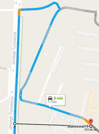
Malgond plans to go. It's just 220 meters off his daily commute to work!
 |
 |

| ||
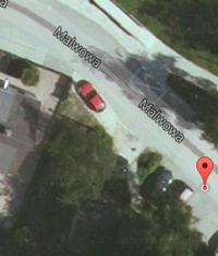
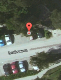
| Planned detour from my daily commute routine. | The point is on the street next to the second parking spot. | This is how it looks in 3D view... | ||
 |
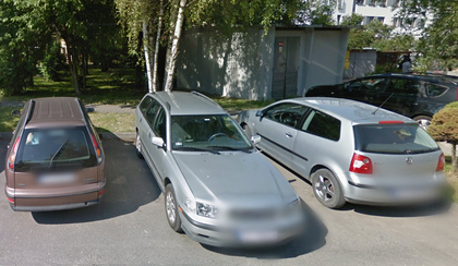
...and in street view. | |||
Expedition
I haven't ventured for a geohashing expedition for a long time already, therefore I could not miss such an opportunity. According to Google Maps, the hash was located on a residential street very close to the road I drive to work every day.
The expedition itself was trivial. On my way to work I had turned right on an intersection I usually travel straight through and after negotiating another few turns and driving along narrow residential streets I have arrived at the spot. Because it was on the pavement, I wanted to drive right through it to get a rather mediocre version of speed racer achievement - the legal speed there is only 30 km/h. I was alone in the car this time snd had no tripod or holder therefore documenting that feat proved difficult and not particularly safe: I was trying to hold the camera straight while steering with the other hand. A few attempts to drive along the hashpoint failed or produced unsatisfactory results. I have parked the car nearby and get out to get some still shots.
After that I got back in the car and made another couple of circles around the neighbourhood trying to get a more or less steady recording. The sun was shining right into my windscreen making the attempts still more difficult. Finally I got a good shot and drove off to work.
Announcement
To the mysterious viewer of my video from a Kraków Centrum E network:
(Yes, I am sooo evil and I keep logs of my HTTP server!)
Please, oh please, show up on this wiki! There were never too many geohashers in Kraków - and in the whole Poland in fact. Judging from the lack of new expeditions I am currently the only semi-active one in the whole country! I feel so lonely... It would be nice to meet some other person crazy enough to go to random places. Drop me a note on my talk page or something. Cheers!
Achievements
Malgond earned the Land geohash achievement
|
Malgond earned the No Batteries Geohash Achievement
|
Malgond earned the Speed racer achievement
|


