Difference between revisions of "2017-07-31 52 1"
From Geohashing
imported>Sourcerer m (Lonesome tree near the hashpoint.) |
imported>Sourcerer m (→Achievements) |
||
| Line 42: | Line 42: | ||
}} | }} | ||
| − | [[Category: | + | [[Category:Expeditions]] |
| − | |||
[[Category:Expeditions with photos]] | [[Category:Expeditions with photos]] | ||
[[Category:Coordinates reached]] | [[Category:Coordinates reached]] | ||
| − | |||
Revision as of 13:53, 31 July 2017
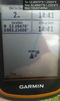
| Mon 31 Jul 2017 in Norwich, UK: 52.4046955, 1.2500251 geohashing.info google osm bing/os kml crox |
Location
A public footpath half way down a field perimeter at South Green, Norfolk, UK.
Participants
Plans
Go after lunch.
Expedition
Photos
- Gallery
Arrived.
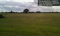
Lonesome tree near the hashpoint.


Achievements
Expeditions and Plans
| 2017-07-31 | ||
|---|---|---|
| Genève, Switzerland | Crox, by proxy | Prangins, Switzerland, near the former HBG transmission site |
| Cambridge, United Kingdom | PaintedJaguar | On a public footpath just off Dunstan Street in Ely, and just over 350m fro... |
| Norwich, United Kingdom | Sourcerer | A public footpath half way down a field perimeter at South Green, Norfolk, ... |
| Utrecht, Netherlands | JwB | Parking lot in an industrial area in Almere |
Sourcerer's Expedition Links
2017-07-20 52 1 - 2017-07-31 52 1 - 2017-08-01 52 1 - KML file download of Sourcerer's expeditions for use with Google Earth.