Difference between revisions of "2017-08-23 51 9"
From Geohashing
imported>GeorgDerReisende (new report) |
imported>FippeBot m (Location) |
||
| (One intermediate revision by one other user not shown) | |||
| Line 1: | Line 1: | ||
| − | |||
| − | |||
| − | |||
| − | |||
| − | |||
| − | |||
| − | |||
| − | |||
| − | |||
| − | |||
{{meetup graticule | {{meetup graticule | ||
| lat=51 | | lat=51 | ||
| lon=9 | | lon=9 | ||
| − | | date= | + | | date=2017-08-23 |
}} | }} | ||
| Line 19: | Line 9: | ||
== Location == | == Location == | ||
| − | + | ||
| + | The hash lay on the gravel of the rails at Hann. Münden railway station. | ||
== Participants == | == Participants == | ||
| − | + | ||
| − | + | [[User:GeorgDerReisende|GeorgDerReisende]] | |
== Plans == | == Plans == | ||
| − | + | ||
| + | bus and hitchhiking and walking where necessary | ||
== Expedition == | == Expedition == | ||
| − | |||
| − | + | I started by bus and at Wilhelmshausen I started to hitchhike and arrived easily at Hann. Münden. I walked to the railway station and found the hash beside the rails and not on them. | |
| − | |||
== Photos == | == Photos == | ||
| Line 39: | Line 29: | ||
--> | --> | ||
<gallery perrow="5"> | <gallery perrow="5"> | ||
| + | Image:2017-08-23 51 9 GeorgDerReisende 0321.jpg | there the hash was | ||
| + | Image:2017-08-23 51 9 GeorgDerReisende 0324.jpg | my GPS told me I was on the rails | ||
| + | Image:2017-08-23 51 9 GeorgDerReisende 0328.jpg | but I wasn't | ||
| + | Image:2017-08-23 51 9 GeorgDerReisende 0330.jpg | the west: the platform | ||
| + | Image:2017-08-23 51 9 GeorgDerReisende 0331.jpg | the north: the rails | ||
| + | Image:2017-08-23 51 9 GeorgDerReisende 0332.jpg | the east: railway tracks | ||
| + | Image:2017-08-23 51 9 GeorgDerReisende 0333.jpg | the south: part of Hann. Münden | ||
| + | Image:2017-08-23 51 9 GeorgDerReisende 0334.jpg | the hash | ||
| + | Image:2017-08-23 51 9 GeorgDerReisende 0336.jpg | the hash from the platform | ||
| + | Image:2017-08-23 51 9 GeorgDerReisende 0337.jpg | the geohasher | ||
| + | Image:2017-08-23 51 9 GeorgDerReisende 0339.jpg | I hadn't to take this train | ||
</gallery> | </gallery> | ||
| Line 45: | Line 46: | ||
<!-- Add any achievement ribbons you earned below, or remove this section --> | <!-- Add any achievement ribbons you earned below, or remove this section --> | ||
| − | + | {{Easy_geohash | latitude = 51 | longitude = 9 | date = 2017-08-23 | name = GeorgDerReisende }} | |
| − | |||
| − | |||
| − | + | [[Category:Expeditions]] | |
| − | + | [[Category:Expeditions with photos]] | |
| − | |||
| − | [[Category: | ||
| − | |||
| − | |||
| − | |||
| − | |||
| − | |||
| − | |||
| − | |||
| − | |||
| − | |||
| − | |||
| − | |||
| − | |||
[[Category:Coordinates reached]] | [[Category:Coordinates reached]] | ||
| − | + | {{location|DE|NI|GÖ}} | |
| − | |||
| − | |||
| − | |||
| − | |||
| − | |||
| − | |||
| − | |||
| − | |||
| − | |||
| − | |||
| − | |||
| − | |||
| − | |||
| − | |||
| − | |||
| − | |||
| − | |||
Latest revision as of 02:54, 16 August 2019
| Wed 23 Aug 2017 in 51,9: 51.4122177, 9.6572634 geohashing.info google osm bing/os kml crox |
Location
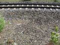
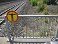
The hash lay on the gravel of the rails at Hann. Münden railway station.
Participants
Plans
bus and hitchhiking and walking where necessary
Expedition
I started by bus and at Wilhelmshausen I started to hitchhike and arrived easily at Hann. Münden. I walked to the railway station and found the hash beside the rails and not on them.
Photos
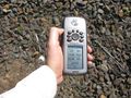
there the hash was
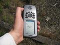
my GPS told me I was on the rails
but I wasn't
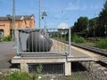
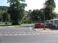
the west: the platform
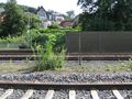
the north: the rails
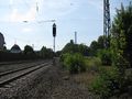
the east: railway tracks
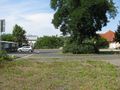
the south: part of Hann. Münden
the hash
the hash from the platform
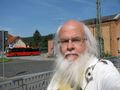
the geohasher
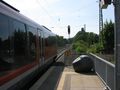
I hadn't to take this train


Achievements
GeorgDerReisende has visited an Easy Geohash
|