Difference between revisions of "2017-10-15 51 9"
From Geohashing
imported>GeorgDerReisende (new report) |
imported>GeorgDerReisende (expedition report for Schauenburg-Elgershausen) |
||
| Line 1: | Line 1: | ||
| − | + | [[Image:{{{image|2017-10-15 51 9 GeorgDerReisende 3389.jpg}}}|thumb|left]] | |
| − | |||
| − | |||
| − | [[Image:{{{image| | ||
| − | |||
| − | |||
| − | |||
| − | |||
| − | |||
| − | |||
{{meetup graticule | {{meetup graticule | ||
| lat=51 | | lat=51 | ||
| Line 19: | Line 10: | ||
== Location == | == Location == | ||
| − | + | ||
| + | The hash lay on a harvested corn field near Elgershausen. | ||
== Participants == | == Participants == | ||
| − | + | ||
| − | + | [[User:GeorgDerReisende|GeorgDerReisende]] | |
== Plans == | == Plans == | ||
| − | + | ||
| + | Tram, bus, walking. | ||
== Expedition == | == Expedition == | ||
| − | + | ||
| + | I took the bus 53 to the stop Elgershausen, Raiffeisen and walked to the hash. It was on an empty corn field about 75 meters north of the road. | ||
== Tracklog == | == Tracklog == | ||
| Line 39: | Line 33: | ||
--> | --> | ||
<gallery perrow="5"> | <gallery perrow="5"> | ||
| + | Image:2017-10-15 51 9 GeorgDerReisende 3370.jpg | 75 meters to hash | ||
| + | Image:2017-10-15 51 9 GeorgDerReisende 3373.jpg | the hash | ||
| + | Image:2017-10-15 51 9 GeorgDerReisende 3374.jpg | proof | ||
| + | Image:2017-10-15 51 9 GeorgDerReisende 3375.jpg | the north | ||
| + | Image:2017-10-15 51 9 GeorgDerReisende 3376.jpg | the east | ||
| + | Image:2017-10-15 51 9 GeorgDerReisende 3377.jpg | the south | ||
| + | Image:2017-10-15 51 9 GeorgDerReisende 3378.jpg | the west | ||
| + | Image:2017-10-15 51 9 GeorgDerReisende 3380.jpg | the geohasher | ||
| + | Image:2017-10-15 51 9 GeorgDerReisende 3389.jpg | the guard | ||
</gallery> | </gallery> | ||
| Line 45: | Line 48: | ||
<!-- Add any achievement ribbons you earned below, or remove this section --> | <!-- Add any achievement ribbons you earned below, or remove this section --> | ||
| − | + | {{Easy_geohash | latitude = 51 | longitude = 9 | date = 2017-10-15 | name = GeorgDerReisende }} | |
| − | |||
| − | |||
| − | + | [[Category:Expeditions]] | |
| − | + | [[Category:Expeditions with photos]] | |
| − | |||
| − | [[Category: | ||
| − | |||
| − | |||
| − | |||
| − | |||
| − | |||
| − | |||
| − | |||
| − | |||
| − | |||
| − | |||
| − | |||
| − | |||
[[Category:Coordinates reached]] | [[Category:Coordinates reached]] | ||
| − | |||
| − | |||
| − | |||
| − | |||
| − | |||
| − | |||
| − | |||
| − | |||
| − | |||
| − | |||
| − | |||
| − | |||
| − | |||
| − | |||
| − | |||
| − | |||
| − | |||
| − | |||
Revision as of 16:39, 15 October 2017

| Sun 15 Oct 2017 in 51,9: 51.2729565, 9.3923632 geohashing.info google osm bing/os kml crox |
Location
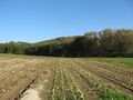
The hash lay on a harvested corn field near Elgershausen.
Participants
Plans
Tram, bus, walking.
Expedition
I took the bus 53 to the stop Elgershausen, Raiffeisen and walked to the hash. It was on an empty corn field about 75 meters north of the road.
Tracklog
Photos
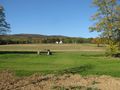
75 meters to hash
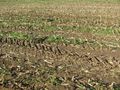
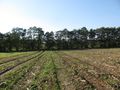
the hash
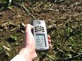
proof
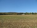
the north
the east
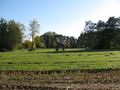
the south
the west
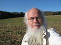
the geohasher
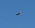
the guard


Achievements
GeorgDerReisende has visited an Easy Geohash
|