Difference between revisions of "2017-11-19 49 8"
From Geohashing
imported>DODO (→Plans) |
imported>FippeBot m (Location) |
||
| (6 intermediate revisions by one other user not shown) | |||
| Line 33: | Line 33: | ||
== Expedition == | == Expedition == | ||
<!-- how it all turned out. your narrative goes here. --> | <!-- how it all turned out. your narrative goes here. --> | ||
| + | Didn't make it in time to Mannheim, but reached it on my way back. The hash was less than 100 m next to the B9. You can't stop there because irt is a highway, but there is an exit just 200 m further. And a parking place 400 m from the hash. All in all a 1 KM detour by car and a 1 KM walk. | ||
== Tracklog == | == Tracklog == | ||
| Line 41: | Line 42: | ||
Image:2012-##-## ## ## Alpha.jpg | Witty Comment | Image:2012-##-## ## ## Alpha.jpg | Witty Comment | ||
--> | --> | ||
| − | <gallery perrow=" | + | <gallery perrow="4"> |
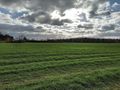
| + | Image:2017-11-19_49_8-1.jpg|view into the field | ||
| + | Image:2017-11-19_49_8-2.jpg|tracktor-track (kinfdof) | ||
| + | Image:2017-11-19_49_8-7.png|proof | ||
| + | Image:2017-11-19_49_8-3.jpg|to the east: the road | ||
| + | Image:2017-11-19_49_8-4.jpg|the west... | ||
| + | Image:2017-11-19_49_8-5.jpg|and the north: nothing | ||
| + | Image:2017-11-19_49_8-6.jpg|happy hasher | ||
</gallery> | </gallery> | ||
| Line 47: | Line 55: | ||
{{#vardefine:ribbonwidth|800px}} | {{#vardefine:ribbonwidth|800px}} | ||
<!-- Add any achievement ribbons you earned below, or remove this section --> | <!-- Add any achievement ribbons you earned below, or remove this section --> | ||
| + | {{land geohash | ||
| + | | latitude = 49 | ||
| + | | longitude = 8 | ||
| + | | date = 2017-11-19 | ||
| + | | name = DODO | ||
| + | }} | ||
| − | + | {{consecutive geohash | |
| − | + | | count = 2 | |
| − | + | | latitude = 49 | |
| + | | longitude = 8 | ||
| + | | date = 2017-11-18 | ||
| + | | name = DODO | ||
| + | }} | ||
| − | + | {{xkcd centurion | |
| + | |count=13 | ||
| + | |name=DODO | ||
| + | }} | ||
| − | + | [[Category:Expeditions]] | |
| − | |||
| − | [[Category: | ||
| − | |||
| − | |||
| − | |||
| − | |||
| − | |||
| − | |||
| − | |||
| − | |||
| − | |||
| − | |||
| − | |||
| − | |||
[[Category:Coordinates reached]] | [[Category:Coordinates reached]] | ||
| − | + | {{location|DE|RP|RP}} | |
| − | |||
| − | |||
| − | |||
| − | |||
| − | |||
| − | |||
| − | |||
| − | |||
| − | |||
| − | |||
| − | |||
| − | |||
| − | |||
| − | |||
| − | |||
| − | |||
| − | |||
Latest revision as of 03:09, 16 August 2019
| Sun 19 Nov 2017 in 49,8: 49.3910480, 8.4139942 geohashing.info google osm bing/os kml crox |
Location
A field next to the motorway B9 near Schifferstadt.
Participants
Plans
Stop by on my way to Mannheim.
Expedition
Didn't make it in time to Mannheim, but reached it on my way back. The hash was less than 100 m next to the B9. You can't stop there because irt is a highway, but there is an exit just 200 m further. And a parking place 400 m from the hash. All in all a 1 KM detour by car and a 1 KM walk.
Tracklog
Photos
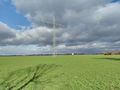
view into the field
tracktor-track (kinfdof)
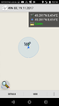
proof
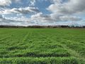
to the east: the road
the west...

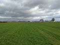
and the north: nothing
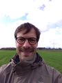
happy hasher


Achievements
DODO earned the Land geohash achievement
|
DODO earned the Consecutive geohash achievement
|
DODO earned the xkcd Decurion achievement
|