Difference between revisions of "2018-02-05 52 1"
From Geohashing
imported>Sourcerer m ([live] Arrived.) |
imported>Sourcerer m ([live picture] Proof. [http://www.openstreetmap.org/?lat=52.17107892&lon=1.50544882&zoom=16&layers=B000FTF @52.1711,1.5054]) |
||
| Line 26: | Line 26: | ||
== Photos == | == Photos == | ||
<gallery caption="Gallery" widths="200px" heights="200px" perrow="3"> | <gallery caption="Gallery" widths="200px" heights="200px" perrow="3"> | ||
| + | |||
| + | Image:2018-02-05_52_1_Sourcerer_1517824409673.jpg | Proof. [http://www.openstreetmap.org/?lat=52.17107892&lon=1.50544882&zoom=16&layers=B000FTF @52.1711,1.5054] | ||
</gallery> | </gallery> | ||
Revision as of 09:55, 5 February 2018
| Mon 5 Feb 2018 in Norwich, UK: 52.1710395, 1.5054934 geohashing.info google osm bing/os kml crox |
Location
A woodland path at Snape, Suffolk, UK.
Participants
Plans
Just go ...
Expedition
- Arrived. -- Sourcerer (talk) @52.1711,1.5054 09:54, 5 February 2018 (GMT)
Photos
- Gallery
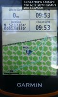
Proof. @52.1711,1.5054

Achievements
Expeditions and Plans
| 2018-02-05 | ||
|---|---|---|
| Norwich, United Kingdom | Sourcerer | A woodland path at Snape, Suffolk, UK. |
Sourcerer's Expedition Links
2018-01-31 52 1 - 2018-02-05 52 1 - 2018-02-06 52 1 - KML file download of Sourcerer's expeditions for use with Google Earth.