Difference between revisions of "2018-03-17 49 8"
From Geohashing
imported>DODO (Created page with "{{subst:Expedition |lat = 49 |lon = 8 |date = 2018-03-17 }}") |
imported>DODO |
||
| Line 20: | Line 20: | ||
== Location == | == Location == | ||
<!-- where you've surveyed the hash to be --> | <!-- where you've surveyed the hash to be --> | ||
| + | In the forest near Hassloch (hate hole) | ||
== Participants == | == Participants == | ||
<!-- who attended: If you link to your wiki user name in this section, your expedition will be picked up by the various statistics generated for geohashing. You may use three tildes ~ as a shortcut to automatically insert the user signature of the account you are editing with. | <!-- who attended: If you link to your wiki user name in this section, your expedition will be picked up by the various statistics generated for geohashing. You may use three tildes ~ as a shortcut to automatically insert the user signature of the account you are editing with. | ||
--> | --> | ||
| − | + | [[User:DODO|DODO]] | |
== Plans == | == Plans == | ||
<!-- what were the original plans --> | <!-- what were the original plans --> | ||
| + | Go there by bull. | ||
== Expedition == | == Expedition == | ||
<!-- how it all turned out. your narrative goes here. --> | <!-- how it all turned out. your narrative goes here. --> | ||
| + | Well, originally I wanted to go on my bike but the lady said, I was to ill ro do so, and so she convinced me to take the support of the bull. It was past 3 already, and so I agreed, to try to reach the hash at hash o'clock. It was surprisingly cold (especially compared to yesterday). I stopped the bull 3 minutes late, good enough for me. 75 m to go, into a forest full of very small needle beams. Soon enough I reached the place, took some pictures, left a mark and returned to the bull. I continued my way and rode a perfect tron (except the way into the forest to the hash and back ofcource | ||
== Tracklog == | == Tracklog == | ||
<!-- if your GPS device keeps a log, you may post a link here --> | <!-- if your GPS device keeps a log, you may post a link here --> | ||
| + | [https://www.komoot.de/tour/27909679 32 KM by bull] | ||
== Photos == | == Photos == | ||
| Line 38: | Line 42: | ||
Image:2012-##-## ## ## Alpha.jpg | Witty Comment | Image:2012-##-## ## ## Alpha.jpg | Witty Comment | ||
--> | --> | ||
| − | <gallery perrow=" | + | <gallery perrow="4"> |
| + | Image:2018-03-17_49_8-1.jpg|75 m in this direction | ||
| + | Image:2018-03-17_49_8-2.jpg|bull is waiting here | ||
| + | Image:2018-03-17_49_8-3.jpg|southwards and | ||
| + | Image:2018-03-17_49_8-4.jpg|to the north | ||
| + | Image:2018-03-17_49_8-5.jpg|hasher | ||
| + | Image:2018-03-17_49_8-6.jpg|mark | ||
| + | Image:2018-03-17_49_8-7.jpg|proof | ||
</gallery> | </gallery> | ||
| Line 44: | Line 55: | ||
{{#vardefine:ribbonwidth|800px}} | {{#vardefine:ribbonwidth|800px}} | ||
<!-- Add any achievement ribbons you earned below, or remove this section --> | <!-- Add any achievement ribbons you earned below, or remove this section --> | ||
| + | {{land geohash | ||
| + | | latitude = 49 | ||
| + | | longitude = 8 | ||
| + | | date = 2018-03-17 | ||
| + | | name = DODO | ||
| + | }} | ||
| − | + | {{consecutive geohash | |
| − | + | | count = 2 | |
| − | + | | latitude = 49 | |
| + | | longitude = 8 | ||
| + | | date = 2018-03-17 | ||
| + | | name = DODO | ||
| + | }} | ||
| − | + | {{Template:Tron | |
| + | | latitude = 49 | ||
| + | | longitude = 8 | ||
| + | | date = 2018-03-17 | ||
| + | | name = DODO | ||
| + | | tracklog = https://www.komoot.de/tour/27909679 | ||
| + | | possessive = his | ||
| + | }} | ||
| − | + | {{xkcd centurion | |
| − | + | |count=14 | |
| − | + | |name=DODO | |
| − | + | }} | |
| − | + | [[Category:Expeditions]] | |
| − | |||
| − | |||
| − | |||
| − | |||
| − | |||
| − | |||
| − | |||
| − | |||
| − | |||
[[Category:Coordinates reached]] | [[Category:Coordinates reached]] | ||
| − | |||
| − | |||
| − | |||
| − | |||
| − | |||
| − | |||
| − | |||
| − | |||
| − | |||
| − | |||
| − | |||
| − | |||
| − | |||
| − | |||
| − | |||
| − | |||
| − | |||
| − | |||
Revision as of 17:16, 17 March 2018
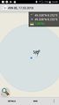
| Sat 17 Mar 2018 in 49,8: 49.3381776, 8.2515859 geohashing.info google osm bing/os kml crox |
Location
In the forest near Hassloch (hate hole)
Participants
Plans
Go there by bull.
Expedition
Well, originally I wanted to go on my bike but the lady said, I was to ill ro do so, and so she convinced me to take the support of the bull. It was past 3 already, and so I agreed, to try to reach the hash at hash o'clock. It was surprisingly cold (especially compared to yesterday). I stopped the bull 3 minutes late, good enough for me. 75 m to go, into a forest full of very small needle beams. Soon enough I reached the place, took some pictures, left a mark and returned to the bull. I continued my way and rode a perfect tron (except the way into the forest to the hash and back ofcource
Tracklog
Photos
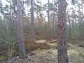
75 m in this direction
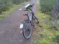
bull is waiting here
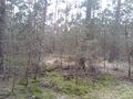
southwards and
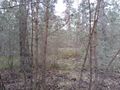
to the north

hasher
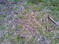
mark
proof


Achievements
DODO earned the Land geohash achievement
|
DODO earned the Consecutive geohash achievement
|
DODO earned the Tron achievement
|
DODO earned the xkcd Decurion achievement
|