Difference between revisions of "2018-05-31 52 -0"
From Geohashing
imported>Sourcerer m ([live picture] HP. [http://www.openstreetmap.org/?lat=52.72468150&lon=-.62747598&zoom=16&layers=B000FTF @52.7247,-.6275]) |
imported>Sourcerer m (→New expedition) |
||
| Line 1: | Line 1: | ||
| − | |||
| − | |||
| − | |||
| − | |||
| − | |||
| − | |||
| − | |||
| − | |||
| − | |||
| − | |||
{{meetup graticule | {{meetup graticule | ||
| lat=52 | | lat=52 | ||
| lon=-0 | | lon=-0 | ||
| date=2018-05-31 | | date=2018-05-31 | ||
| − | }} | + | | graticule_name=Northampton |
| − | + | | graticule_link=Northampton, United Kingdom}} | |
| − | |||
__NOTOC__ | __NOTOC__ | ||
| + | == Location == | ||
| − | + | A field perimeter north of Greetham, Rutland,UK. | |
| − | |||
== Participants == | == Participants == | ||
| − | + | ||
| − | + | * [[User:Sourcerer|Sourcerer]] | |
== Plans == | == Plans == | ||
| − | + | ||
| + | Visit on the way to friends in Staffordshire. | ||
== Expedition == | == Expedition == | ||
| − | |||
| − | + | There was parking at the Greetham community centre and sports fields. The hashpoint was under 200 metres north, just off a public footpath. | |
| − | |||
| − | |||
| − | |||
| − | |||
| − | |||
| − | |||
| − | |||
| + | == Photos == | ||
| + | <gallery caption="Gallery" widths="200px" heights="200px" perrow="3"> | ||
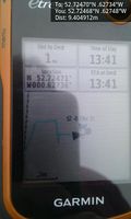
Image:2018-05-31_52_-0_Sourcerer_1527770354721.jpg | Arrived. [http://www.openstreetmap.org/?lat=52.72468150&lon=-.62747598&zoom=16&layers=B000FTF @52.7247,-.6275] | Image:2018-05-31_52_-0_Sourcerer_1527770354721.jpg | Arrived. [http://www.openstreetmap.org/?lat=52.72468150&lon=-.62747598&zoom=16&layers=B000FTF @52.7247,-.6275] | ||
| Line 46: | Line 30: | ||
Image:2018-05-31_52_-0_Sourcerer_1527770376279.jpg | HP. [http://www.openstreetmap.org/?lat=52.72468150&lon=-.62747598&zoom=16&layers=B000FTF @52.7247,-.6275] | Image:2018-05-31_52_-0_Sourcerer_1527770376279.jpg | HP. [http://www.openstreetmap.org/?lat=52.72468150&lon=-.62747598&zoom=16&layers=B000FTF @52.7247,-.6275] | ||
</gallery> | </gallery> | ||
| + | |||
== Achievements == | == Achievements == | ||
{{#vardefine:ribbonwidth|800px}} | {{#vardefine:ribbonwidth|800px}} | ||
| − | |||
| − | + | {{Last man standing | |
| − | |||
| − | |||
| − | + | | latitude = 52 | |
| + | | longitude = -0 | ||
| + | | date = 2018-05-31 | ||
| + | | gender = man | ||
| + | | name = Sourcerer | ||
| + | }} | ||
| − | + | {{Sourcerer_links | |
| − | + | | prev = 2018-05-26_52_-0 | |
| − | + | | curr = 2018-05-31_52_-0 | |
| − | -- | + | | next = 2018-06-05_52_1 |
| + | | date = 2018-05-31 | ||
| + | }} | ||
| − | |||
| − | |||
| − | |||
[[Category:Expeditions]] | [[Category:Expeditions]] | ||
| − | |||
[[Category:Expeditions with photos]] | [[Category:Expeditions with photos]] | ||
| − | |||
| − | |||
| − | |||
| − | |||
| − | |||
[[Category:Coordinates reached]] | [[Category:Coordinates reached]] | ||
| − | |||
| − | |||
| − | |||
| − | |||
| − | |||
| − | |||
| − | |||
| − | |||
| − | |||
| − | |||
| − | |||
| − | |||
| − | |||
| − | |||
| − | |||
| − | |||
| − | |||
| − | |||
Revision as of 00:26, 3 June 2018
| Thu 31 May 2018 in Northampton: 52.7247045, -0.6273420 geohashing.info google osm bing/os kml crox |
Location
A field perimeter north of Greetham, Rutland,UK.
Participants
Plans
Visit on the way to friends in Staffordshire.
Expedition
There was parking at the Greetham community centre and sports fields. The hashpoint was under 200 metres north, just off a public footpath.
Photos
- Gallery
Arrived. @52.7247,-.6275
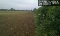
HP. @52.7247,-.6275
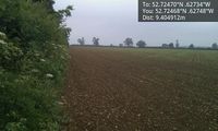
HP. @52.7247,-.6275


Achievements
Sourcerer earned the Last man standing achievement
|
Expeditions and Plans
| 2018-05-31 | ||
|---|---|---|
| Beersheba, Israel | Yosef | A farm near the town of Nitzanim. I just moved to this area so I was reall... |
| Northampton, United Kingdom | Sourcerer | A field perimeter north of Greetham, Rutland,UK. |
Sourcerer's Expedition Links
2018-05-26_52_-0 - 2018-05-31_52_-0 - 2018-06-05_52_1 - KML file download of Sourcerer's expeditions for use with Google Earth.