Difference between revisions of "2018-08-19 51 9"
imported>Digiphono (→Plans) |
imported>FippeBot m (Location) |
||
| (6 intermediate revisions by one other user not shown) | |||
| Line 33: | Line 33: | ||
== Expedition == | == Expedition == | ||
<!-- how it all turned out. your narrative goes here. --> | <!-- how it all turned out. your narrative goes here. --> | ||
| + | This sunday morning I decided to go for todays geohash - simply because I needed to get out a little bit after spending the saturday at home. Even if it was a drive of 65 kilometers, I packed some equipment and drove to Schoningen, where I arrived 11:30 am. I parked my car in a shady place and wandered to the geohash. My mobile phone had some problems connecting, so I walked down a road I thought it was the right one, but it turned out to be the wrong one, after my phone connected again and showed me the location of the geohash! | ||
| + | |||
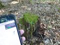
| + | So I took a little detour along a fence, which was between a field and the forest, and reached the actual path I wanted to follow a few minutes later. My luck was, that from here, an old logging trail lead me directly to the hash! I didn't even have to leave this path to reach an accuracy of less than one meter ;-) The hash was an old tree stump, so I sat down on it and enjoyed the silence here in the woods for a few minutes, made some pictures to proof my visit and turned around... | ||
| + | |||
| + | On my way back, I watched some cows on a field to the right, having a cornfield on my left - and suddenly I heard some noise from the cornfield and thought it might be some boars! But as I looked around, it turned out to be one of the cows, that managed to break out from the field, enjoying some corn... Guess both of us were scared for a moment, since the cow run away to find his way on his meadow and joined the other cows! | ||
| + | |||
| + | A few minutes later I reached my car and drove some kilometers to do another hike to catch up with some geocaches... | ||
== Tracklog == | == Tracklog == | ||
<!-- if your GPS device keeps a log, you may post a link here --> | <!-- if your GPS device keeps a log, you may post a link here --> | ||
| + | <gallery> | ||
| + | Image:Track_2018_08_19_51_9.jpg | Todays track | ||
| + | </gallery> | ||
== Photos == | == Photos == | ||
| Line 41: | Line 51: | ||
Image:2012-##-## ## ## Alpha.jpg | Witty Comment | Image:2012-##-## ## ## Alpha.jpg | Witty Comment | ||
--> | --> | ||
| − | <gallery | + | <gallery> |
| + | Image:2018_08_19_51_9_001.JPG | The hash is up there in the forest | ||
| + | Image:2018_08_19_51_9_002.JPG | The fence I had to follow | ||
| + | Image:2018_08_19_51_9_003.JPG | The hash - wow, that accuracy ;-) | ||
| + | Image:2018_08_19_51_9_004.JPG | The hash - have a seat and relax - which I did | ||
| + | Image:2018_08_19_51_9_005.JPG | The little cow thinking 'why did you disturb me?' | ||
| + | Image:2018_08_19_51_9_006.JPG | The little cow zoomed in | ||
</gallery> | </gallery> | ||
| Line 47: | Line 63: | ||
{{#vardefine:ribbonwidth|800px}} | {{#vardefine:ribbonwidth|800px}} | ||
<!-- Add any achievement ribbons you earned below, or remove this section --> | <!-- Add any achievement ribbons you earned below, or remove this section --> | ||
| + | {{Two to the N achievement | ||
| + | |||
| + | | count = 1 | ||
| + | | date = 2018-08-19 | ||
| + | | latitude = 51 | ||
| + | | longitude = 9 | ||
| + | | name = Digiphono | ||
| + | | reached = true | ||
| + | }} | ||
<!-- =============== USEFUL CATEGORIES FOLLOW ================ | <!-- =============== USEFUL CATEGORIES FOLLOW ================ | ||
Delete the next line ONLY if you have chosen the appropriate categories below. If you are unsure, don't worry. People will read your report and help you with the classification. --> | Delete the next line ONLY if you have chosen the appropriate categories below. If you are unsure, don't worry. People will read your report and help you with the classification. --> | ||
| − | |||
<!-- ==REQUEST FOR TWITTER BOT== Please leave either the New report or the Expedition planning category in as long as you work on it. This helps the twitter bot a lot with announcing the right outcome at the right moment. --> | <!-- ==REQUEST FOR TWITTER BOT== Please leave either the New report or the Expedition planning category in as long as you work on it. This helps the twitter bot a lot with announcing the right outcome at the right moment. --> | ||
| Line 61: | Line 85: | ||
<!-- If all those plans are never acted upon, change [[Category:Expedition planning]] to [[Category:Not reached - Did not attempt]]. --> | <!-- If all those plans are never acted upon, change [[Category:Expedition planning]] to [[Category:Not reached - Did not attempt]]. --> | ||
| − | |||
[[Category:Expeditions]] | [[Category:Expeditions]] | ||
| − | |||
[[Category:Expeditions with photos]] | [[Category:Expeditions with photos]] | ||
| − | |||
| − | |||
| − | |||
| − | |||
| − | |||
[[Category:Coordinates reached]] | [[Category:Coordinates reached]] | ||
| − | + | {{location|DE|NI|NOM}} | |
| − | |||
| − | |||
| − | |||
| − | |||
| − | |||
| − | |||
| − | |||
| − | |||
| − | |||
| − | |||
| − | |||
| − | |||
| − | |||
| − | |||
| − | |||
| − | |||
| − | |||
Latest revision as of 03:58, 16 August 2019
| Sun 19 Aug 2018 in 51,9: 51.6292021, 9.6951131 geohashing.info google osm bing/os kml crox |
Location
In a forest east of Schoningen / Uslar.
Participants
Plans
There was no actual planning for this one, but I decided to go there spontaneousy this sunday morning.
Expedition
This sunday morning I decided to go for todays geohash - simply because I needed to get out a little bit after spending the saturday at home. Even if it was a drive of 65 kilometers, I packed some equipment and drove to Schoningen, where I arrived 11:30 am. I parked my car in a shady place and wandered to the geohash. My mobile phone had some problems connecting, so I walked down a road I thought it was the right one, but it turned out to be the wrong one, after my phone connected again and showed me the location of the geohash!
So I took a little detour along a fence, which was between a field and the forest, and reached the actual path I wanted to follow a few minutes later. My luck was, that from here, an old logging trail lead me directly to the hash! I didn't even have to leave this path to reach an accuracy of less than one meter ;-) The hash was an old tree stump, so I sat down on it and enjoyed the silence here in the woods for a few minutes, made some pictures to proof my visit and turned around...
On my way back, I watched some cows on a field to the right, having a cornfield on my left - and suddenly I heard some noise from the cornfield and thought it might be some boars! But as I looked around, it turned out to be one of the cows, that managed to break out from the field, enjoying some corn... Guess both of us were scared for a moment, since the cow run away to find his way on his meadow and joined the other cows!
A few minutes later I reached my car and drove some kilometers to do another hike to catch up with some geocaches...
Tracklog

Todays track

Photos

The hash is up there in the forest

The fence I had to follow

The hash - wow, that accuracy ;-)
The hash - have a seat and relax - which I did

The little cow thinking 'why did you disturb me?'
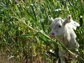
The little cow zoomed in


Achievements
Digiphono earned the Two to the N achievement
|