Difference between revisions of "2018-09-27 46 -122"
From Geohashing
imported>Thomcat ([live picture]Geohasher [http://www.openstreetmap.org/?lat=46.96516220&lon=-122.78846600&zoom=16&layers=B000FTF @46.9652,-122.7885]) |
imported>FippeBot m (Location) |
||
| (3 intermediate revisions by one other user not shown) | |||
| Line 1: | Line 1: | ||
| − | |||
| − | |||
| − | |||
| − | |||
| − | |||
| − | |||
| − | |||
| − | |||
| − | |||
| − | |||
{{meetup graticule | {{meetup graticule | ||
| lat=46 | | lat=46 | ||
| lon=-122 | | lon=-122 | ||
| date=2018-09-27 | | date=2018-09-27 | ||
| + | | graticule_name=Mt. St. Helens | ||
| + | | graticule_link=Mt. St. Helens, Washington | ||
}} | }} | ||
| Line 19: | Line 11: | ||
== Location == | == Location == | ||
| − | + | On a side road near Lacey | |
== Participants == | == Participants == | ||
| − | + | * [[User:Thomcat|Thomcat]] | |
| − | |||
== Plans == | == Plans == | ||
| Line 29: | Line 20: | ||
== Expedition == | == Expedition == | ||
| − | + | I had business in the area, so decided to try for this geohashpoint and add this graticule to my list. First expedition here in over six years! | |
| + | |||
| + | Geo-coordinates on the sat nav system took me right to the spot, parking within 10m. I walked around and got that down to less, but always with a very large error window. Could be these power lines, could be the effect of [https://en.wikipedia.org/wiki/Foo_fighter Foo Fighters]. Regardless, I was on or crossed over the spot several times. | ||
| + | |||
| + | On my way back to Olympia, I passed this sign while entering [https://en.wikipedia.org/wiki/Lacey,_Washington Lacey]. I had no idea it was the City of Trees. Time to go fix that wikipedia entry, though. | ||
== Tracklog == | == Tracklog == | ||
| Line 41: | Line 36: | ||
Image:2018-09-27_46_-122_thomcat_1538078872618.jpg|Geohasher [http://www.openstreetmap.org/?lat=46.96516220&lon=-122.78846600&zoom=16&layers=B000FTF @46.9652,-122.7885] | Image:2018-09-27_46_-122_thomcat_1538078872618.jpg|Geohasher [http://www.openstreetmap.org/?lat=46.96516220&lon=-122.78846600&zoom=16&layers=B000FTF @46.9652,-122.7885] | ||
| + | |||
| + | Image:2018-09-27_46_-122_thomcat_1538079011450.jpg|Southish [http://www.openstreetmap.org/?lat=46.96506860&lon=-122.78842420&zoom=16&layers=B000FTF @46.9651,-122.7884] | ||
| + | |||
| + | Image:2018-09-27_46_-122_thomcat_1538079483867.jpg|Back to Lacey [http://www.openstreetmap.org/?lat=46.98119500&lon=-122.81832000&zoom=16&layers=B000FTF @46.9812,-122.8183] | ||
</gallery> | </gallery> | ||
== Achievements == | == Achievements == | ||
{{#vardefine:ribbonwidth|800px}} | {{#vardefine:ribbonwidth|800px}} | ||
| − | + | {{Minesweeper geohash | |
| − | + | | graticule = Seattle, Washington | |
| − | + | | ranknumber = 5 | |
| − | + | | n = true | |
| − | + | | ne = true | |
| − | + | | e = true | |
| − | + | | s = true | |
| − | + | | sw = true | |
| − | + | | name = Thomcat | |
| − | + | }} | |
| − | |||
| − | |||
| − | |||
| − | |||
[[Category:Expeditions]] | [[Category:Expeditions]] | ||
| − | |||
[[Category:Expeditions with photos]] | [[Category:Expeditions with photos]] | ||
| − | |||
| − | |||
| − | |||
| − | |||
| − | |||
[[Category:Coordinates reached]] | [[Category:Coordinates reached]] | ||
| − | + | {{location|US|WA|TH}} | |
| − | |||
| − | |||
| − | |||
| − | |||
| − | |||
| − | |||
| − | |||
| − | |||
| − | |||
| − | |||
| − | |||
| − | |||
| − | |||
| − | |||
| − | |||
| − | |||
| − | |||
Latest revision as of 03:20, 7 August 2019
| Thu 27 Sep 2018 in Mt. St. Helens: 46.9651340, -122.7884560 geohashing.info google osm bing/os kml crox |
Location
On a side road near Lacey
Participants
Plans
Expedition
I had business in the area, so decided to try for this geohashpoint and add this graticule to my list. First expedition here in over six years!
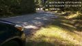
Geo-coordinates on the sat nav system took me right to the spot, parking within 10m. I walked around and got that down to less, but always with a very large error window. Could be these power lines, could be the effect of Foo Fighters. Regardless, I was on or crossed over the spot several times.
On my way back to Olympia, I passed this sign while entering Lacey. I had no idea it was the City of Trees. Time to go fix that wikipedia entry, though.
Tracklog
Photos

Geohasher @46.9652,-122.7885
Southish @46.9651,-122.7884
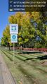
Back to Lacey @46.9812,-122.8183


Achievements
Thomcat achieved level 5 of the Minesweeper Geohash achievement
|