Difference between revisions of "2018-10-17 51 9"
imported>Digiphono (→Location) |
imported>FippeBot m (Location) |
||
| (11 intermediate revisions by one other user not shown) | |||
| Line 1: | Line 1: | ||
| − | |||
| − | |||
| − | |||
| − | |||
| − | |||
| − | |||
| − | |||
| − | |||
| − | |||
| − | |||
{{meetup graticule | {{meetup graticule | ||
| lat=51 | | lat=51 | ||
| Line 20: | Line 10: | ||
== Location == | == Location == | ||
| − | In a forest | + | In a forest west of Vierbach |
== Participants == | == Participants == | ||
| − | + | ||
| − | + | [[User:Digiphono|Digiphono]] | |
== Plans == | == Plans == | ||
| − | + | ||
| + | Right after work I will drive to Vierbach, arrive there at around 14:15 pm, park my car and go for a little hike into the woods. The hash seems to lie some 50 meters off an old trail through the forest, so this might become a succesful expedition! | ||
== Expedition == | == Expedition == | ||
| − | |||
| − | + | ''Personal note: for exactly two months I did my [[2018-08-17 51 9|first geohashing expedition]], today is the 21st trip to a geohash - which, in other terms, means to me, that I seem to enjoy this newly discovered hobby a lot!! August 17th seems like ages away, but it have only been the first two months of active geohashing ;-) Hopefully, the thrill and '''excitement''' will stay - I'm really digging this kind of 'getting out there' and look forward to further adventures!!!'' | |
| − | + | ||
| + | Right as planned, I arrived in Vierbach short after two pm, parked my car and prepared for a little journey on this beautiful day in october... The path was going pretty steep, so I had to stop to take some breath every now and then. I came along the grillhut of this little village, a very nice location with a great view on Vierbach. Then I came nearer to the forest, and both a path and a ditch were leading directly into it. I choose the path, which turned out to be the wrong decision, getting deeper into the woods, but further away from the hash! | ||
| + | |||
| + | So I had to do a right turn to find my way back to the ditch, which I should had followed! After finding it, it turned out to be almost 3 meters deep, so I had to get back a little further to find a good place to cross it. Then I had a look at my app and noticed: only 50 meters to go! Those last meters were pretty easy and I found the hash shortly after... | ||
| + | |||
| + | After about one hour I returned to my car - I had taken a lot of pics on my way - and celebrated my succesful expedition! This really was a nice one for me, discovering some unspoiled nature and enjoying the silence... | ||
== Photos == | == Photos == | ||
| − | < | + | |
| − | Image: | + | <gallery> |
| − | -- | + | Image:2018-10-17_51_9_001.jpg | The way to the hash |
| − | + | Image:2018-10-17_51_9_002.jpg | On my way to the hash | |
| + | Image:2018-10-17_51_9_003.jpg | Approaching the forest | ||
| + | Image:2018-10-17_51_9_004.jpg | Through the forest | ||
| + | Image:2018-10-17_51_9_005.jpg | In the forest | ||
| + | Image:2018-10-17_51_9_006.jpg | The hash - proof | ||
| + | Image:2018-10-17_51_9_007.jpg | The hash | ||
| + | Image:2018-10-17_51_9_008.jpg | The way back | ||
| + | Image:2018-10-17_51_9_009.jpg | Nice view on Vierbach | ||
</gallery> | </gallery> | ||
== Achievements == | == Achievements == | ||
{{#vardefine:ribbonwidth|800px}} | {{#vardefine:ribbonwidth|800px}} | ||
| − | |||
| − | |||
| − | |||
| − | |||
| − | |||
| − | |||
| − | |||
| − | |||
| − | |||
| − | |||
| − | |||
| − | |||
| − | |||
| − | |||
| − | |||
[[Category:Expeditions]] | [[Category:Expeditions]] | ||
| − | |||
[[Category:Expeditions with photos]] | [[Category:Expeditions with photos]] | ||
| − | |||
| − | |||
| − | |||
| − | |||
| − | |||
[[Category:Coordinates reached]] | [[Category:Coordinates reached]] | ||
| − | + | {{location|DE|HE|WIZ}} | |
| − | |||
| − | |||
| − | |||
| − | |||
| − | |||
| − | |||
| − | |||
| − | |||
| − | |||
| − | |||
| − | |||
| − | |||
| − | |||
| − | |||
| − | |||
| − | |||
| − | |||
Latest revision as of 04:12, 16 August 2019
| Wed 17 Oct 2018 in 51,9: 51.1669998, 9.9236046 geohashing.info google osm bing/os kml crox |
Location
In a forest west of Vierbach
Participants
Plans
Right after work I will drive to Vierbach, arrive there at around 14:15 pm, park my car and go for a little hike into the woods. The hash seems to lie some 50 meters off an old trail through the forest, so this might become a succesful expedition!
Expedition
Personal note: for exactly two months I did my first geohashing expedition, today is the 21st trip to a geohash - which, in other terms, means to me, that I seem to enjoy this newly discovered hobby a lot!! August 17th seems like ages away, but it have only been the first two months of active geohashing ;-) Hopefully, the thrill and excitement will stay - I'm really digging this kind of 'getting out there' and look forward to further adventures!!!
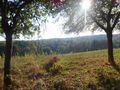
Right as planned, I arrived in Vierbach short after two pm, parked my car and prepared for a little journey on this beautiful day in october... The path was going pretty steep, so I had to stop to take some breath every now and then. I came along the grillhut of this little village, a very nice location with a great view on Vierbach. Then I came nearer to the forest, and both a path and a ditch were leading directly into it. I choose the path, which turned out to be the wrong decision, getting deeper into the woods, but further away from the hash!
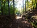
So I had to do a right turn to find my way back to the ditch, which I should had followed! After finding it, it turned out to be almost 3 meters deep, so I had to get back a little further to find a good place to cross it. Then I had a look at my app and noticed: only 50 meters to go! Those last meters were pretty easy and I found the hash shortly after...
After about one hour I returned to my car - I had taken a lot of pics on my way - and celebrated my succesful expedition! This really was a nice one for me, discovering some unspoiled nature and enjoying the silence...
Photos
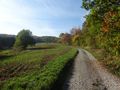
The way to the hash
On my way to the hash
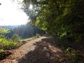
Approaching the forest
Through the forest
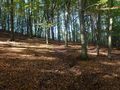
In the forest

The hash - proof
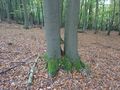
The hash
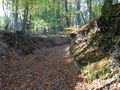
The way back
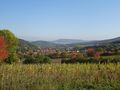
Nice view on Vierbach


