Difference between revisions of "2018-11-12 47 -122"
imported>Thomcat ([live picture]Logging road [http://www.openstreetmap.org/?lat=47.74523560&lon=-122.02882040&zoom=16&layers=B000FTF @47.7452,-122.0288]) |
imported>FippeBot m (Location) |
||
| (7 intermediate revisions by one other user not shown) | |||
| Line 1: | Line 1: | ||
| − | |||
| − | |||
| − | |||
| − | |||
| − | |||
| − | |||
| − | |||
| − | |||
| − | |||
| − | |||
{{meetup graticule | {{meetup graticule | ||
| lat=47 | | lat=47 | ||
| lon=-122 | | lon=-122 | ||
| date=2018-11-12 | | date=2018-11-12 | ||
| + | | graticule_name=Seattle | ||
| + | | graticule_link=Seattle, Washington | ||
}} | }} | ||
| Line 19: | Line 11: | ||
== Location == | == Location == | ||
| − | + | The northern edge of the Ring Hill Forest , between Woodinville and Duvall | |
== Participants == | == Participants == | ||
| − | + | * [[User:Thomcat|Thomcat]] | |
| − | |||
== Plans == | == Plans == | ||
| − | + | Visit before work | |
== Expedition == | == Expedition == | ||
| − | + | [https://www.kingcounty.gov/services/environment/water-and-land/natural-lands/working-resource-lands/ring-hill.aspx Ring Hill Forest] is a working resource land, that is, it was originally logged and now portions will be logged regularly. This seems like a pretty smart plan, and the website contains a lot of excellent details on the subject. | |
| + | |||
| + | The "trail" leading into the wood is a logging road, though grown over with grass in many points. I walked down a bit and easily found a spot near the geohashpoint for today. Not quite as near, but on the same bearing, was a very elaborate treehouse (pictured below). | ||
| + | |||
| + | After requisite photographs (no marker this time), I continued down the road. Various trails peeled off for Tuck Creek and other attractions. I decided to follow the trail labeled "Snoqualmie Overlook", and this resulted in another picture or two below. | ||
| + | |||
| + | With great success on a brisk morning walk (single digit Celsius, upper 30s Fahrenheit) I returned generally uphill to my vehicle and thence onto work. | ||
== Tracklog == | == Tracklog == | ||
| Line 45: | Line 42: | ||
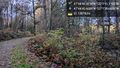
Image:2018-11-12_47_-122_thomcat_1542038977760.jpg|Logging road [http://www.openstreetmap.org/?lat=47.74523560&lon=-122.02882040&zoom=16&layers=B000FTF @47.7452,-122.0288] | Image:2018-11-12_47_-122_thomcat_1542038977760.jpg|Logging road [http://www.openstreetmap.org/?lat=47.74523560&lon=-122.02882040&zoom=16&layers=B000FTF @47.7452,-122.0288] | ||
| + | |||
| + | Image:2018-11-12_47_-122_thomcat_1542039057850.jpg|Geohash house [http://www.openstreetmap.org/?lat=47.74518700&lon=-122.02819640&zoom=16&layers=B000FTF @47.7452,-122.0282] | ||
| + | |||
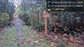
| + | Image:2018-11-12_47_-122_thomcat_1542039145434.jpg|Hash point [http://www.openstreetmap.org/?lat=47.74528940&lon=-122.02809040&zoom=16&layers=B000FTF @47.7453,-122.0281] | ||
| + | |||
| + | Image:2018-11-12_47_-122_thomcat_1542039231310.jpg|Towards the exit [http://www.openstreetmap.org/?lat=47.74518580&lon=-122.02768440&zoom=16&layers=B000FTF @47.7452,-122.0277] | ||
| + | |||
| + | Image:2018-11-12_47_-122_thomcat_1542039486694.jpg|Signpost | ||
| + | |||
| + | Image:2018-11-12_47_-122_thomcat_1542039951250.jpg|Bridge [http://www.openstreetmap.org/?lat=47.74063980&lon=-122.02148910&zoom=16&layers=B000FTF @47.7406,-122.0215] | ||
| + | |||
| + | Image:2018-11-12_47_-122_thomcat_1542040055449.jpg|From the viewpoint | ||
</gallery> | </gallery> | ||
| Line 51: | Line 60: | ||
<!-- Add any achievement ribbons you earned below, or remove this section --> | <!-- Add any achievement ribbons you earned below, or remove this section --> | ||
| − | |||
| − | |||
| − | |||
| − | |||
| − | |||
| − | |||
| − | |||
| − | |||
| − | |||
| − | |||
| − | |||
| − | |||
| − | |||
| − | |||
[[Category:Expeditions]] | [[Category:Expeditions]] | ||
| − | |||
[[Category:Expeditions with photos]] | [[Category:Expeditions with photos]] | ||
| − | |||
| − | |||
| − | |||
| − | |||
| − | |||
[[Category:Coordinates reached]] | [[Category:Coordinates reached]] | ||
| − | + | {{location|US|WA|KN}} | |
| − | |||
| − | |||
| − | |||
| − | |||
| − | |||
| − | |||
| − | |||
| − | |||
| − | |||
| − | |||
| − | |||
| − | |||
| − | |||
| − | |||
| − | |||
| − | |||
| − | |||
Latest revision as of 04:16, 16 August 2019
| Mon 12 Nov 2018 in Seattle: 47.7452559, -122.0280863 geohashing.info google osm bing/os kml crox |
Location
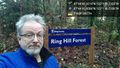
The northern edge of the Ring Hill Forest , between Woodinville and Duvall
Participants
Plans
Visit before work
Expedition
Ring Hill Forest is a working resource land, that is, it was originally logged and now portions will be logged regularly. This seems like a pretty smart plan, and the website contains a lot of excellent details on the subject.
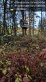
The "trail" leading into the wood is a logging road, though grown over with grass in many points. I walked down a bit and easily found a spot near the geohashpoint for today. Not quite as near, but on the same bearing, was a very elaborate treehouse (pictured below).
After requisite photographs (no marker this time), I continued down the road. Various trails peeled off for Tuck Creek and other attractions. I decided to follow the trail labeled "Snoqualmie Overlook", and this resulted in another picture or two below.
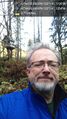
With great success on a brisk morning walk (single digit Celsius, upper 30s Fahrenheit) I returned generally uphill to my vehicle and thence onto work.
Tracklog
Photos
Geohasher @47.7450,-122.0296
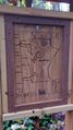
Map

Logging road @47.7452,-122.0288
Geohash house @47.7452,-122.0282
Hash point @47.7453,-122.0281
Towards the exit @47.7452,-122.0277
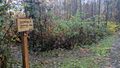
Signpost
Bridge @47.7406,-122.0215
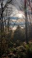
From the viewpoint


