Difference between revisions of "2018-12-31 52 9"
imported>Fippe (New Plans) |
imported>Fippe (New Report) |
||
| Line 14: | Line 14: | ||
==Expedition== | ==Expedition== | ||
| − | I' | + | I took the train in the morning to Visselhövede via Soltau. The walk to the Geohash was nice, after leaving town I first walked through a forest, where I crossed the river [[wikipedia:Lehrde|Lehrde]], which here is only slightly more than a trickle, since the spring is close. The forest is divided by a field, and after crossing it the coordinates were close. |
| + | |||
| + | According to the map, I'd have to go ~100m through the forest without a path, but luckily there was an unmarked path which brought me ~20m close to the coordinates. I'd add it to OSM, but it's invisible on satellite images. The Geohash was not particularily hard to reach. | ||
| + | |||
| + | After recording proof, I went back to Visselhövede, and afterwards took the train back to Hannover via Achim. | ||
| + | |||
| + | ==Photos== | ||
| + | <gallery> | ||
| + | 2018-12-31 52 09 01 Visselhövede.jpg | At the train station in Visselhövede | ||
| + | 2018-12-31 52 09 02 Path.jpg | The path in the forest | ||
| + | 2018-12-31 52 09 03 Lehrde.jpg | The river Lehrde | ||
| + | 2018-12-31 52 09 04 Hoof Print.jpg | A hoof print | ||
| + | 2018-12-31 52 09 05 Proof.png | Proof | ||
| + | 2018-12-31 52 09 06 Geohash.jpg | The Geohash | ||
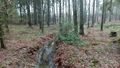
| + | 2018-12-31 52 09 07 Tree.jpg | A tree near the coordinates | ||
| + | 2018-12-31 52 09 08 Trees.jpg | More trees near the coordinates | ||
| + | 2018-12-31 52 09 09 Surroundings.jpg | The surroundings of the Geohash | ||
| + | </gallery> | ||
| + | |||
| + | ==Achievements== | ||
| + | {{#vardefine:ribbonwidth|100%}} | ||
| + | {{land geohash|latitude=52|longitude=9|date=2018-12-31|name=[[User:Fippe|Fippe]]|image=2018-12-31 52 09 06 Geohash.jpg}} | ||
| + | {{regional geohashing|region=the [[User:Fippe/Progress#Landkreis Rotenburg (Wümme)|Rotenburg (Wümme) district]]|count=2|image=Landkreis Rotenburg (Wümme).png|name=[[User:Fippe|Fippe]]}} | ||
__NOTOC__ | __NOTOC__ | ||
| − | [[Category: | + | [[Category:Expeditions]] |
| + | [[Category:Coordinates reached]] | ||
| + | [[Category:Expeditions with photos]] | ||
| + | {{location|DE|NI|ROW}} | ||
| + | [[Category:Expeditions by Fippe]] | ||
Revision as of 17:46, 31 December 2018
| Mon 31 Dec 2018 in Hannover: 52.9654271, 9.5944640 geohashing.info google osm bing/os kml crox |
Location
This Geohash is located in a forest near Visselhövede.
Participants
Expedition
I took the train in the morning to Visselhövede via Soltau. The walk to the Geohash was nice, after leaving town I first walked through a forest, where I crossed the river Lehrde, which here is only slightly more than a trickle, since the spring is close. The forest is divided by a field, and after crossing it the coordinates were close.
According to the map, I'd have to go ~100m through the forest without a path, but luckily there was an unmarked path which brought me ~20m close to the coordinates. I'd add it to OSM, but it's invisible on satellite images. The Geohash was not particularily hard to reach.
After recording proof, I went back to Visselhövede, and afterwards took the train back to Hannover via Achim.
Photos
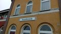
At the train station in Visselhövede
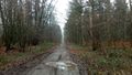
The path in the forest
The river Lehrde
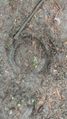
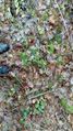
A hoof print
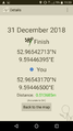
Proof
The Geohash
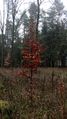
A tree near the coordinates
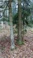
More trees near the coordinates
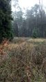
The surroundings of the Geohash


Achievements
Fippe earned the Land geohash achievement
|
Fippe earned the Regional geohashing achievement
|