Difference between revisions of "2019-04-18 48 11"
imported>Solli ([live] Been there, details follow) |
imported>Solli |
||
| Line 1: | Line 1: | ||
| − | |||
| − | |||
| − | |||
| − | |||
| − | |||
| − | |||
| − | |||
| − | |||
| − | |||
| − | |||
{{meetup graticule | {{meetup graticule | ||
| lat=48 | | lat=48 | ||
| Line 15: | Line 5: | ||
}} | }} | ||
| − | |||
__NOTOC__ | __NOTOC__ | ||
== Location == | == Location == | ||
| − | + | In a wood near Glon and Baindlkirch | |
== Participants == | == Participants == | ||
| − | + | * [[User:Solli|Solli]] | |
| − | |||
== Plans == | == Plans == | ||
| − | + | I was more or less in this area anyway and the hashpoint seemed to be accessible, so why not? | |
== Expedition == | == Expedition == | ||
| − | + | I drove on a dirt track to a crossing around 300 metres from the cash, walked across the field and went into the wood. There I had to run in circles a bit because of the bad GPS signal. Finally the app said success, so I marked the spot and went back to the car. | |
| − | + | On my way back I stopped near an old clay pit and watched the birds. I saw several buzzards, a red kite and even a stork (the first one this year). | |
| − | |||
| − | |||
| − | |||
== Photos == | == Photos == | ||
| − | |||
| − | |||
| − | |||
<gallery perrow="5"> | <gallery perrow="5"> | ||
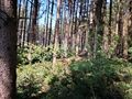
| + | Image:2019-04-18 48 11 Solli 01.jpg | The hash wood, viewed from the parking spot | ||
| + | Image:2019-04-18 48 11 Solli 02.jpg | Proof | ||
| + | Image:2019-04-18 48 11 Solli 03.jpg | Standing at the hashpoint | ||
| + | Image:2019-04-18 48 11 Solli 04.jpg | Stupid Grin (tm) | ||
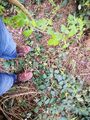
| + | Image:2019-04-18 48 11 Solli 05.jpg | The hashpoint, marked with a stick | ||
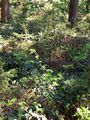
| + | Image:2019-04-18 48 11 Solli 06.jpg | View from the hashpoint (not much of a view) | ||
| + | Image:2019-04-18 48 11 Solli 07.jpg | The hashpoint again | ||
| + | Image:2019-04-18 48 11 Solli 08.jpg | Back to my trusty hashmobile | ||
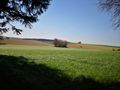
| + | Image:2019-04-18 48 11 Solli 09.jpg | An old clay pit nearby | ||
| + | Image:2019-04-18 48 11 Solli 10.jpg | Red kite | ||
</gallery> | </gallery> | ||
== Achievements == | == Achievements == | ||
{{#vardefine:ribbonwidth|800px}} | {{#vardefine:ribbonwidth|800px}} | ||
| − | + | {{land geohash | |
| − | + | | latitude = 48 | |
| − | + | | longitude = 11 | |
| − | + | | date = 2019-04-18 | |
| − | + | | name = Solli | |
| − | + | }} | |
| − | |||
| − | |||
| − | |||
| − | |||
| − | |||
| − | |||
| − | |||
| − | |||
| − | |||
[[Category:Expeditions]] | [[Category:Expeditions]] | ||
| − | |||
[[Category:Expeditions with photos]] | [[Category:Expeditions with photos]] | ||
| − | |||
| − | |||
| − | |||
| − | |||
| − | |||
| − | |||
| − | |||
[[Category:Coordinates reached]] | [[Category:Coordinates reached]] | ||
| − | |||
| − | |||
| − | |||
| − | |||
| − | |||
| − | |||
| − | |||
| − | |||
| − | |||
| − | |||
| − | |||
| − | |||
| − | |||
| − | |||
| − | |||
| − | |||
| − | |||
| − | |||
Revision as of 10:13, 19 April 2019
| Thu 18 Apr 2019 in 48,11: 48.2725625, 11.1111662 geohashing.info google osm bing/os kml crox |
Location
In a wood near Glon and Baindlkirch
Participants
Plans
I was more or less in this area anyway and the hashpoint seemed to be accessible, so why not?
Expedition
I drove on a dirt track to a crossing around 300 metres from the cash, walked across the field and went into the wood. There I had to run in circles a bit because of the bad GPS signal. Finally the app said success, so I marked the spot and went back to the car.
On my way back I stopped near an old clay pit and watched the birds. I saw several buzzards, a red kite and even a stork (the first one this year).
Photos
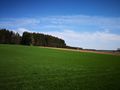
The hash wood, viewed from the parking spot
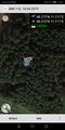
Proof
Standing at the hashpoint
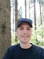
Stupid Grin (tm)
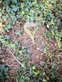
The hashpoint, marked with a stick
View from the hashpoint (not much of a view)
The hashpoint again
Back to my trusty hashmobile
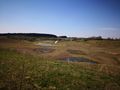
An old clay pit nearby
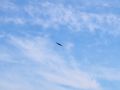
Red kite


Achievements
Solli earned the Land geohash achievement
|