Difference between revisions of "2019-06-22 47 -122"
imported>Coyotebush ([live picture]On the spot) |
imported>FippeBot m (Location) |
||
| (3 intermediate revisions by 2 users not shown) | |||
| Line 1: | Line 1: | ||
| − | |||
| − | |||
| − | |||
| − | |||
| − | |||
| − | |||
| − | |||
| − | |||
| − | |||
| − | |||
{{meetup graticule | {{meetup graticule | ||
| lat=47 | | lat=47 | ||
| lon=-122 | | lon=-122 | ||
| date=2019-06-22 | | date=2019-06-22 | ||
| + | | graticule_name=Seattle | ||
| + | | graticule_link=Seattle, Washington | ||
}} | }} | ||
| Line 19: | Line 11: | ||
== Location == | == Location == | ||
| − | + | A parking lot just east of Bellevue Square | |
== Participants == | == Participants == | ||
| − | + | * [[User:Thomcat|Thomcat]] | |
| − | + | * [[User:Coyotebush|Coyotebush]] | |
== Plans == | == Plans == | ||
| Line 29: | Line 21: | ||
== Expedition == | == Expedition == | ||
| − | |||
| + | === [[User:Thomcat|Thomcat]] === | ||
| + | |||
| + | Spotted this on Friday, decided on a quick expedition after umpiring two baseball games in the morning at Rainier Beach HS. | ||
| + | |||
| + | Weather was overcast, games went quickly enough. A quick trip around the south end of the lake led me easily to the location. | ||
| + | |||
| + | The parking lot is marked "Paccar parking only" and had plenty of signage to that effect. Even a security guard walking around. However, it being Saturday, the gate was up and unmanned - so I pulled in to a spot near the spot and tried to spot the location. | ||
| + | |||
| + | Hmmm, geohashdroid drifting a lot, and no power wires to speak of. Big buildings, perhaps? Sent the point to google maps, which showed where I was standing - and an icon indicating my actual location was some 8 meters away. | ||
| + | |||
| + | Standing on what should be the spot, I launched geohashdroid again and got a spot within 2 meters, so I marked an X with the chalk and took appropriate pictures. This being a completely impromptu (and unannounced) expedition, I didn't wait around for anyone else, but headed home. | ||
| + | |||
| + | === [[User:Coyotebush|coyotebush]] === | ||
| + | |||
| + | Got notified Saturday morning and figured I would aim for Saturday meetup time. It would have been comfortable weather for a bike ride across the lake, but I decided on bus. | ||
| + | |||
| + | However, I didn't adequately account for traffic delays due to the [[wikipedia:Fremont Solstice Parade|Fremont Solstice Parade]] (famous for the unofficial contingent of body-painted cyclists) so fell behind schedule when making a connection. | ||
*Bus was delayed, will be there about 16:15 -- [[User:Coyotebush|Coyotebush]] ([[User talk:Coyotebush|talk]]) 15:48, 22 June 2019 (PDT) | *Bus was delayed, will be there about 16:15 -- [[User:Coyotebush|Coyotebush]] ([[User talk:Coyotebush|talk]]) 15:48, 22 June 2019 (PDT) | ||
| + | |||
| + | Walked a block from the bus, into the parking lot, and towards the far end. There I promptly spotted the X as my clue that Thomcat had already been by. GPS on my phone seemed just fine. | ||
| + | |||
| + | I stopped nearby for a hot bubble tea before a differently-routed bus journey back home. It was tasty but unfortunately didn't agree very well with my stomach on the ride. | ||
| + | |||
== Tracklog == | == Tracklog == | ||
<!-- if your GPS device keeps a log, you may post a link here --> | <!-- if your GPS device keeps a log, you may post a link here --> | ||
| Line 63: | Line 76: | ||
<!-- Add any achievement ribbons you earned below, or remove this section --> | <!-- Add any achievement ribbons you earned below, or remove this section --> | ||
| − | + | {{Public transport geohash | |
| − | |||
| − | |||
| − | |||
| − | |||
| − | + | | latitude = 47 | |
| − | + | | longitude = -122 | |
| − | + | | date = 2019-06-22 | |
| − | + | | name = coyotebush | |
| − | + | }} | |
| − | |||
[[Category:Expeditions]] | [[Category:Expeditions]] | ||
| − | |||
[[Category:Expeditions with photos]] | [[Category:Expeditions with photos]] | ||
| − | |||
| − | |||
| − | |||
| − | |||
| − | |||
| − | |||
| − | |||
[[Category:Coordinates reached]] | [[Category:Coordinates reached]] | ||
| − | + | {{location|US|WA|KN}} | |
| − | |||
| − | |||
| − | |||
| − | |||
| − | |||
| − | |||
| − | |||
| − | |||
| − | |||
| − | |||
| − | |||
| − | |||
| − | |||
| − | |||
| − | |||
| − | |||
| − | |||
Latest revision as of 12:42, 14 July 2019
| Sat 22 Jun 2019 in Seattle: 47.6157841, -122.1999362 geohashing.info google osm bing/os kml crox |
Location
A parking lot just east of Bellevue Square
Participants
Plans
Expedition
Thomcat
Spotted this on Friday, decided on a quick expedition after umpiring two baseball games in the morning at Rainier Beach HS.
Weather was overcast, games went quickly enough. A quick trip around the south end of the lake led me easily to the location.
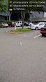
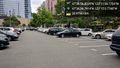
The parking lot is marked "Paccar parking only" and had plenty of signage to that effect. Even a security guard walking around. However, it being Saturday, the gate was up and unmanned - so I pulled in to a spot near the spot and tried to spot the location.
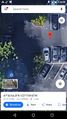
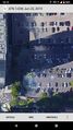
Hmmm, geohashdroid drifting a lot, and no power wires to speak of. Big buildings, perhaps? Sent the point to google maps, which showed where I was standing - and an icon indicating my actual location was some 8 meters away.
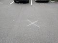
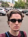
Standing on what should be the spot, I launched geohashdroid again and got a spot within 2 meters, so I marked an X with the chalk and took appropriate pictures. This being a completely impromptu (and unannounced) expedition, I didn't wait around for anyone else, but headed home.
coyotebush
Got notified Saturday morning and figured I would aim for Saturday meetup time. It would have been comfortable weather for a bike ride across the lake, but I decided on bus.
However, I didn't adequately account for traffic delays due to the Fremont Solstice Parade (famous for the unofficial contingent of body-painted cyclists) so fell behind schedule when making a connection.
- Bus was delayed, will be there about 16:15 -- Coyotebush (talk) 15:48, 22 June 2019 (PDT)
Walked a block from the bus, into the parking lot, and towards the far end. There I promptly spotted the X as my clue that Thomcat had already been by. GPS on my phone seemed just fine.
I stopped nearby for a hot bubble tea before a differently-routed bus journey back home. It was tasty but unfortunately didn't agree very well with my stomach on the ride.
Tracklog
Photos

Work first, then geohash
X marks something @47.6157,-122.2001

Geohasher @47.6158,-122.1999
Google maps confused
Paccar parking @47.6158,-122.2002
Found the X
Second geohasher
On the spot


Achievements
coyotebush earned the Public transport geohash achievement
|