Difference between revisions of "2019-08-03 43 -86"
From Geohashing
imported>Mcbaneg (Created page with "<!-- If you did not specify these parameters in the template, please substitute appropriate values for IMAGE, LAT, LON, and DATE (YYYY-MM-DD format) {{{image|dummy.jpg}}}|...") |
imported>FippeBot m (Location) |
||
| (2 intermediate revisions by 2 users not shown) | |||
| Line 27: | Line 27: | ||
== Plans == | == Plans == | ||
This looks straightforward, on the south edge of a rural road. I'll try to be there at 4 pm. | This looks straightforward, on the south edge of a rural road. I'll try to be there at 4 pm. | ||
| + | |||
| + | == Expedition == | ||
| + | The hashpoint was accessible as expected. I arrived around 4:15 (bad planning, wrong turns, etc.) and hung out until just a little after 4:30. | ||
| + | |||
| + | This was my 2<sup>7</sup>th expedition! | ||
| + | |||
| + | <!-- Insert pictures between the gallery tags using the following format: | ||
| + | Image:2012-##-## ## ## Alpha.jpg | Witty Comment | ||
| + | --> | ||
| + | <gallery perrow="4"> | ||
| + | Image:2019-08-03_43_-86_006.png | Proof | ||
| + | Image:2019-08-03_43_-86_013.jpg | Grin | ||
| + | Image:2019-08-03_43_-86_009.jpg | View E from hashpoint, showing Cline Road and hashmobile | ||
| + | Image:2019-08-03_43_-86_014.jpg | View NE, showing center-pivot irrigation system in action | ||
| + | Image:2019-08-03_43_-86_015.jpg | Queen Anne's lace at hashpoint | ||
| + | </gallery> | ||
| + | |||
| + | == Achievements == | ||
| + | |||
| + | {{Two to the N achievement | ||
| + | |||
| + | | count = 7 | ||
| + | | date = 2019-08-03 | ||
| + | | latitude = 43 | ||
| + | | longitude = -86 | ||
| + | | name = [[User:Mcbaneg | Mcbaneg]] | ||
| + | }} | ||
| Line 33: | Line 60: | ||
<!-- Potential categories. Please include all the ones appropriate to your expedition --> | <!-- Potential categories. Please include all the ones appropriate to your expedition --> | ||
| − | [[Category: | + | [[Category:Expeditions]] |
| + | [[Category:Expeditions with photos]] | ||
| + | [[Category:Coordinates reached]] | ||
| + | {{location|US|MI|MG}} | ||
Latest revision as of 02:42, 5 August 2019
| Sat 3 Aug 2019 in 43,-86: 43.1760465, -86.1228009 geohashing.info google osm bing/os kml crox |
Location
side of Cline Road, Fruitport, MI
Participants
Plans
This looks straightforward, on the south edge of a rural road. I'll try to be there at 4 pm.
Expedition
The hashpoint was accessible as expected. I arrived around 4:15 (bad planning, wrong turns, etc.) and hung out until just a little after 4:30.
This was my 27th expedition!
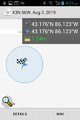
Proof

Grin
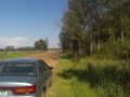
View E from hashpoint, showing Cline Road and hashmobile
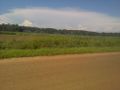
View NE, showing center-pivot irrigation system in action
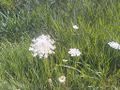
Queen Anne's lace at hashpoint


Achievements
Mcbaneg earned the Two to the N achievement
|