Difference between revisions of "2013-04-16 55 37"
imported>Vb (Created page with "{{subst:Expedition |lat = 55 |lon = 37 |date = 2013-04-16 }}") |
m (Replacing tracklog = File:2013-04-16 55 37 track.jpg with tracklog = {{canonicalurl:File:2013-04-16 55 37 track.jpg}}) |
||
| (13 intermediate revisions by 3 users not shown) | |||
| Line 19: | Line 19: | ||
== Location == | == Location == | ||
<!-- where you've surveyed the hash to be --> | <!-- where you've surveyed the hash to be --> | ||
| + | Shabolovka street, on the sidewalk. | ||
== Participants == | == Participants == | ||
<!-- who attended: If you link to your wiki user name in this section, your expedition will be picked up by the various statistics generated for geohashing. You may use three tildes ~ as a shortcut to automatically insert the user signature of the account you are editing with. | <!-- who attended: If you link to your wiki user name in this section, your expedition will be picked up by the various statistics generated for geohashing. You may use three tildes ~ as a shortcut to automatically insert the user signature of the account you are editing with. | ||
--> | --> | ||
| + | [[User:Vb|vb]] ([[User talk:Vb|talk]]) | ||
== Plans == | == Plans == | ||
<!-- what were the original plans --> | <!-- what were the original plans --> | ||
| + | To cure insomnia by having a long walk. | ||
== Expedition == | == Expedition == | ||
<!-- how it all turned out. your narrative goes here. --> | <!-- how it all turned out. your narrative goes here. --> | ||
| + | ~7h walk home-hash-home. Some blisters, but otherwise feel great. | ||
| + | |||
| + | GPS refused to behave at the hash, probably because of the nearby Shuhov tower (TV/radio transmission), so categorising it as no GPS expedition. | ||
| + | |||
| + | The hash turned out to be not on the sidewalk but just at the side of the street, since sidewalks are separated from the street by some meters of trees an what would be grass in summer. | ||
| + | |||
| + | |||
| + | Walk distance: "My Tracks" on the phone shows 35.5 km. "Google Earth" - 34.5. After removing obvious GPS glitches with "GPX Editor" - 32.7. After downsampling initial 10k+ points to about 1400 - 32.6, further downsampling to about 100 points, which is too few - 32.1km. Finally approximating as 32.5km. | ||
| + | |||
| + | Tron: not a pure pure Tron, since I entered and exited shops etc, and made last few meters to the entrance of the building where I live the by the same path - but still within limits, as I understand. | ||
== Tracklog == | == Tracklog == | ||
| − | + | [[Image:2013-04-16_55_37_track.jpg|250px]] | |
== Photos == | == Photos == | ||
| Line 38: | Line 51: | ||
--> | --> | ||
<gallery perrow="5"> | <gallery perrow="5"> | ||
| + | 2013-04-16 55 37 P1000299.jpg | Trinity Church on Shabolovka (originally built in 1699, then rebuilt several times) as seen from the hash | ||
| + | 2013-04-16 55 37 P1000300.jpg | apartment building (built in 1962), closest to the hash. | ||
| + | 2013-04-16 55 37 P1000301.jpg | surprisingly couldn't find any info on this building across the street from the hash, excerpt that it is obviously an old one. | ||
| + | 2013-04-16 55 37 P1000304.jpg | panorama at the hash. | ||
| + | 2013-04-16 55 37 P1000305.jpg | Tram depot (1909, Shukhov) is about 400m north from the hash. | ||
| + | 2013-04-16 55 37 P1000314.jpg | Famous [http://en.wikipedia.org/wiki/Shukhov_Tower Shukhov Tower] (1922) is about 600m south from the hash (as seen from the tram depot). | ||
</gallery> | </gallery> | ||
| Line 44: | Line 63: | ||
<!-- Add any achievement ribbons you earned below, or remove this section --> | <!-- Add any achievement ribbons you earned below, or remove this section --> | ||
| + | {{Tron | latitude = 55 | longitude = 37 | date = 2013-04-16 | tracklog = {{canonicalurl:File:2013-04-16 55 37 track.jpg}} | possessive = his | name = [[User:Vb|vb]] }} | ||
| + | {{Walk geohash | latitude = 55 | longitude = 37 | date = 2013-04-16 | name = [[User:Vb|vb]] | distance = 32.5km | image = 2013-04-16_55_37_track.jpg }} | ||
| − | |||
| − | |||
| − | |||
| − | |||
| − | |||
| − | |||
| − | |||
| − | |||
| − | |||
| − | |||
[[Category:Expeditions]] | [[Category:Expeditions]] | ||
| − | |||
[[Category:Expeditions with photos]] | [[Category:Expeditions with photos]] | ||
| − | |||
[[Category:Expedition without GPS]] | [[Category:Expedition without GPS]] | ||
| − | |||
| − | |||
| − | |||
[[Category:Coordinates reached]] | [[Category:Coordinates reached]] | ||
| − | + | [[Category:Walk geohash achievement]] | |
| − | + | [[Category:Land geohash achievement]] | |
| − | + | [[Category:Tron achievement]] | |
| − | [[Category: | + | {{location|RU|MOW}} |
| − | |||
| − | |||
| − | [[Category: | ||
| − | |||
| − | |||
| − | [[Category: | ||
| − | |||
| − | |||
| − | |||
| − | |||
| − | |||
| − | |||
| − | |||
| − | |||
Latest revision as of 11:52, 19 February 2020
| Tue 16 Apr 2013 in 55,37: 55.7227043, 37.6105782 geohashing.info google osm bing/os kml crox |
Location
Shabolovka street, on the sidewalk.
Participants
Plans
To cure insomnia by having a long walk.
Expedition
~7h walk home-hash-home. Some blisters, but otherwise feel great.
GPS refused to behave at the hash, probably because of the nearby Shuhov tower (TV/radio transmission), so categorising it as no GPS expedition.
The hash turned out to be not on the sidewalk but just at the side of the street, since sidewalks are separated from the street by some meters of trees an what would be grass in summer.
Walk distance: "My Tracks" on the phone shows 35.5 km. "Google Earth" - 34.5. After removing obvious GPS glitches with "GPX Editor" - 32.7. After downsampling initial 10k+ points to about 1400 - 32.6, further downsampling to about 100 points, which is too few - 32.1km. Finally approximating as 32.5km.
Tron: not a pure pure Tron, since I entered and exited shops etc, and made last few meters to the entrance of the building where I live the by the same path - but still within limits, as I understand.
Tracklog

Photos
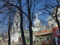
Trinity Church on Shabolovka (originally built in 1699, then rebuilt several times) as seen from the hash

apartment building (built in 1962), closest to the hash.

surprisingly couldn't find any info on this building across the street from the hash, excerpt that it is obviously an old one.

panorama at the hash.
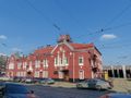
Tram depot (1909, Shukhov) is about 400m north from the hash.
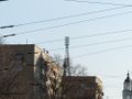
Famous Shukhov Tower (1922) is about 600m south from the hash (as seen from the tram depot).


Achievements
vb earned the Tron achievement
|
vb earned the Walk geohash Achievement
|