Difference between revisions of "2016-11-02 33 -84"
imported>Thomcat (An expedition message sent via Geohash Droid for Android.) |
m (Replacing http://wiki.xkcd.com/geohashing/Atlanta%2C_Georgia with Atlanta, Georgia) |
||
| (13 intermediate revisions by 3 users not shown) | |||
| Line 1: | Line 1: | ||
| − | + | {{meetup graticule | |
| − | + | | map=<map lat="33" lon="-84" date="2016-11-02" /> | |
| − | |||
| − | |||
| − | |||
| − | |||
| − | |||
| − | |||
| − | |||
| − | --> | ||
| − | |||
| lat=33 | | lat=33 | ||
| lon=-84 | | lon=-84 | ||
| date=2016-11-02 | | date=2016-11-02 | ||
| + | | graticule_name=Atlanta | ||
| + | | graticule_link=Atlanta, Georgia | ||
}} | }} | ||
| + | |||
| + | == Graticule == | ||
| + | |||
| + | [[Atlanta, Georgia|Atlanta]] | ||
<!-- edit as necessary --> | <!-- edit as necessary --> | ||
| Line 19: | Line 16: | ||
== Location == | == Location == | ||
| − | + | In the parking lot of an AllState office in North West Redan. | |
| − | == | + | == People == |
| − | + | ||
| − | + | * [[User:NWoodruff|NWoodruff]] | |
| + | * [[User:Thomcat|Thomcat]] | ||
== Plans == | == Plans == | ||
| − | + | The plan was to meetup with Thomcat. I got finished with what I needed to do this evening, not knowing that Thomcat was going to make it to the point. I left out at about 8:15pm for the hash spot and arrived at about 8:50pm. | |
== Expedition == | == Expedition == | ||
| − | + | Arrived at the airport a little late, plotted the route to Clemson from Atlanta... which passed close to Stone Mountain and the hashpoint. The former would be hard to see in the dark, but the latter... achievable! Posted about it on the talk page, sorry I couldn't have researched earlier in the day. | |
| + | |||
| + | Drove that way and explained the slight detour to my drag-along colleague. He was game, and in the end, it didn't alter our route timing as much as the 15 minute traffic backup did. | ||
| + | |||
| + | *On the point -- [[User:Thomcat|Thomcat]] ([[User talk:Thomcat|talk]]) [http://www.openstreetmap.org/?lat=33.75778480&lon=-84.19723340&zoom=16&layers=B000FTF @33.7578,-84.1972] 19:19, 2 November 2016 (EDT) | ||
| + | |||
| + | Posted to the Atlanta talk page again to signal the expedition, then continued on - after a fortifying stop for a milkshake. | ||
| + | |||
| + | *On the point -- [[User:NWoodruff|NWoodruff]] 20:52, 2 November 2016 (EDT) | ||
== Tracklog == | == Tracklog == | ||
| − | + | [http://xkcd.nathanwoodruff.com/XKCD-2016-11-02_33_-84.gpx NWoodruff 2016-11-02] | |
== Photos == | == Photos == | ||
| Line 39: | Line 45: | ||
--> | --> | ||
<gallery perrow="5"> | <gallery perrow="5"> | ||
| + | |||
| + | Image:2016-11-02_33_-84_thomcat_1478128923286.jpg|on to SC | ||
| + | |||
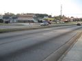
| + | Image:2016-11-02_33_-84_thomcat_1478129853985.jpg|Quick stop on the road [http://www.openstreetmap.org/?lat=33.82123860&lon=-84.26444940&zoom=16&layers=B000FTF @33.8212,-84.2644] | ||
| + | Image:20161102_33_-84NW01.JPG | Standing in the parking lot of the AllState office in North West Redan. | ||
| + | Image:2010032633-84NW04.JPG | deja vu.. I knew I had been there before... in 2010.. [[2010-03-26_33_-84]] | ||
</gallery> | </gallery> | ||
== Achievements == | == Achievements == | ||
| − | |||
| − | |||
| − | |||
| − | |||
| − | |||
| − | |||
| − | |||
| − | |||
| − | |||
| − | |||
| − | |||
| − | |||
| − | |||
| − | |||
| − | |||
| − | |||
[[Category:Expeditions]] | [[Category:Expeditions]] | ||
| − | |||
[[Category:Expeditions with photos]] | [[Category:Expeditions with photos]] | ||
| − | |||
| − | |||
| − | |||
| − | |||
| − | |||
[[Category:Coordinates reached]] | [[Category:Coordinates reached]] | ||
| − | + | {{location|US|GA|DA}} | |
| − | |||
| − | |||
| − | |||
| − | |||
| − | |||
| − | |||
| − | |||
| − | |||
| − | |||
| − | |||
| − | |||
| − | |||
| − | |||
| − | |||
| − | |||
| − | |||
| − | |||
Latest revision as of 12:11, 19 February 2020
| Wed 2 Nov 2016 in Atlanta: 33.7577610, -84.1971701 geohashing.info google osm bing/os kml crox |
Graticule
Location
In the parking lot of an AllState office in North West Redan.
People
Plans
The plan was to meetup with Thomcat. I got finished with what I needed to do this evening, not knowing that Thomcat was going to make it to the point. I left out at about 8:15pm for the hash spot and arrived at about 8:50pm.
Expedition
Arrived at the airport a little late, plotted the route to Clemson from Atlanta... which passed close to Stone Mountain and the hashpoint. The former would be hard to see in the dark, but the latter... achievable! Posted about it on the talk page, sorry I couldn't have researched earlier in the day.
Drove that way and explained the slight detour to my drag-along colleague. He was game, and in the end, it didn't alter our route timing as much as the 15 minute traffic backup did.
- On the point -- Thomcat (talk) @33.7578,-84.1972 19:19, 2 November 2016 (EDT)
Posted to the Atlanta talk page again to signal the expedition, then continued on - after a fortifying stop for a milkshake.
- On the point -- NWoodruff 20:52, 2 November 2016 (EDT)
Tracklog
Photos

on to SC

Quick stop on the road @33.8212,-84.2644
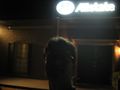
Standing in the parking lot of the AllState office in North West Redan.
deja vu.. I knew I had been there before... in 2010.. 2010-03-26_33_-84


