Difference between revisions of "2010-10-09 41 -72"
imported>Jiml m (Expand Template) |
m (Replacing http://wiki.xkcd.com/wgh/images/My_Path.jpg with {{filepath:My_Path.jpg}}) |
||
| (9 intermediate revisions by 5 users not shown) | |||
| Line 1: | Line 1: | ||
| − | |||
| − | |||
| − | |||
| − | |||
| − | |||
| − | |||
| − | |||
| − | |||
| − | |||
| − | |||
| − | |||
| − | |||
| − | |||
| − | |||
| − | |||
| − | |||
| − | |||
| − | |||
{{meetup graticule | {{meetup graticule | ||
| lat=41 | | lat=41 | ||
| Line 22: | Line 4: | ||
| date=2010-10-09 | | date=2010-10-09 | ||
}} | }} | ||
| − | |||
| − | |||
__NOTOC__ | __NOTOC__ | ||
== Location == | == Location == | ||
| − | + | In the woods of Sunset Rock State Park within sight of the blue-blazed trail. | |
== Participants == | == Participants == | ||
| − | + | [[User:asmiller-ke6seh|Seth]] | |
| − | |||
| − | |||
| − | |||
== Expedition == | == Expedition == | ||
| − | + | The well-worn track detailed in the hash point description is actually a natural gas pipeline right-of-way. After parking on the shoulder of North Shuttle Road, I walked north until I came to a point where the blue-blazed trail crosses the pipeline route. Along this portion of the trip, I found a long abandoned plastic road pylon (missing its heavy black base) which I took along with me to use, conveniently, to mark the hash point once it was found. | |
| − | + | Turning left (west) and walking up hill along the trail, I came to an abandoned road which was probably used when this area was farmland about half a century earlier and turned north. I then bushwacked my way west, approaching the hash point, an old rusted hulk of an automobile was visible, as was the stone wall outlining a rectangular area (visible on aerial photos in Google maps). Reaching the hash point, I posted a "the Internet was here" sign which I sealed inside a one gallon Ziplock(tm) bag, and taped to the found road pylon - this I leaned against a medium sized fallen tree and propped in place with a long and forked stick. | |
| − | |||
| − | + | I then headed south, bushwacking my way the short distance to return to the blue-blazed trail, not crossing my previous path, and proceeded south where I met up with the public road. Turning eastward, again, I followed the road back to my car. The entire walk was approximately one mile in, around, out, and back again to my car. A very pleasant excursion. I was able to verify on the ground what I had interpreted in the aerial photos -- the gas pipeline right-of-way, the old farm field surrounded by a stone wall, various stands of evergreen trees, and the trail running back out of the woods. Total time spent was around an hour of enjoyment. | |
| − | |||
| − | |||
| − | -- | ||
| − | |||
| − | |||
== Achievements == | == Achievements == | ||
| − | {{ | + | {{Tron |
| − | |||
| + | | latitude = 41 | ||
| + | | longitude = -72 | ||
| + | | tracklog = {{filepath:My_Path.jpg}} | ||
| + | | date = 2010-10-09 | ||
| + | | possessive = his | ||
| + | | name = Seth | ||
| + | }} | ||
| − | |||
| − | |||
| − | |||
| − | |||
| − | |||
| − | |||
| − | |||
| − | |||
| − | |||
| − | |||
[[Category:Expeditions]] | [[Category:Expeditions]] | ||
| − | |||
[[Category:Expeditions with photos]] | [[Category:Expeditions with photos]] | ||
| − | |||
| − | |||
| − | |||
| − | |||
| − | |||
[[Category:Coordinates reached]] | [[Category:Coordinates reached]] | ||
| − | + | {{location|US|CT|HA}} | |
| − | |||
| − | |||
| − | |||
| − | |||
| − | |||
| − | |||
| − | |||
| − | |||
| − | |||
Latest revision as of 12:57, 19 February 2020
| Sat 9 Oct 2010 in 41,-72: 41.6427434, -72.8359639 geohashing.info google osm bing/os kml crox |
Location
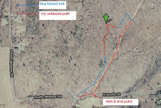
In the woods of Sunset Rock State Park within sight of the blue-blazed trail.
Participants
Expedition
The well-worn track detailed in the hash point description is actually a natural gas pipeline right-of-way. After parking on the shoulder of North Shuttle Road, I walked north until I came to a point where the blue-blazed trail crosses the pipeline route. Along this portion of the trip, I found a long abandoned plastic road pylon (missing its heavy black base) which I took along with me to use, conveniently, to mark the hash point once it was found.
Turning left (west) and walking up hill along the trail, I came to an abandoned road which was probably used when this area was farmland about half a century earlier and turned north. I then bushwacked my way west, approaching the hash point, an old rusted hulk of an automobile was visible, as was the stone wall outlining a rectangular area (visible on aerial photos in Google maps). Reaching the hash point, I posted a "the Internet was here" sign which I sealed inside a one gallon Ziplock(tm) bag, and taped to the found road pylon - this I leaned against a medium sized fallen tree and propped in place with a long and forked stick.
I then headed south, bushwacking my way the short distance to return to the blue-blazed trail, not crossing my previous path, and proceeded south where I met up with the public road. Turning eastward, again, I followed the road back to my car. The entire walk was approximately one mile in, around, out, and back again to my car. A very pleasant excursion. I was able to verify on the ground what I had interpreted in the aerial photos -- the gas pipeline right-of-way, the old farm field surrounded by a stone wall, various stands of evergreen trees, and the trail running back out of the woods. Total time spent was around an hour of enjoyment.
Achievements
Seth earned the Tron achievement
|