Difference between revisions of "2015-12-17 51 9"
From Geohashing
imported>GeorgDerReisende (new report) |
m (Replacing http://wiki.xkcd.com/wgh/images/a/a1/2015-12-17_51_9_GeorgDerReisende_1.png with {{filepath:2015-12-17_51_9_GeorgDerReisende_1.png}}) |
||
| (3 intermediate revisions by 2 users not shown) | |||
| Line 1: | Line 1: | ||
| − | |||
| − | |||
| − | |||
| − | |||
| − | |||
| − | |||
| − | |||
| − | |||
| − | |||
| − | |||
{{meetup graticule | {{meetup graticule | ||
| lat=51 | | lat=51 | ||
| Line 19: | Line 9: | ||
== Location == | == Location == | ||
| − | + | ||
| + | The hash lay in the Sandweg in Kassel-Jungfernkopf. | ||
== Participants == | == Participants == | ||
| − | + | ||
| − | + | [[User:GeorgDerReisende|GeorgDerReisende]] | |
== Plans == | == Plans == | ||
| − | + | ||
| + | I wanted to make a Tron and I wanted to be at the hash at sunrise. | ||
== Expedition == | == Expedition == | ||
| − | + | ||
| + | {| | ||
| + | |- | ||
| + | ! style="width:300px" | !! style="width:300px" | !! style="width:300px" | | ||
| + | |- | ||
| + | | [[Image:2015-12-17 51 9 GeorgDerReisende 7893.jpg | 300px ]] || [[Image:2015-12-17 51 9 GeorgDerReisende 7895.jpg | 300px ]] || I left home at 7:25, what I thought as good enough time to walk to the hash and arriving there at 8:20, the time my Garmin showed as the time of sunrise. I started at the Arnimstraße and then I walked along the Simmershäuser Straße. | ||
| + | |- | ||
| + | | [[Image:2015-12-17 51 9 GeorgDerReisende 7896.jpg | 300px ]] || [[Image:2015-12-17 51 9 GeorgDerReisende 7897.jpg | 300px ]] || I walked to the left into the Quellbachweg and then to the right into the Fürstenbrücker Straße. This part of the street is officially unnamed, and some years ago I had to call the fire brigade, and they didn't find the address. The other end of the street has this name. | ||
| + | |- | ||
| + | | [[Image:2015-12-17 51 9 GeorgDerReisende 7899.jpg | 300px ]] || || In the middle of the street and at it's highest place I had an overview over the city in the morning. | ||
| + | |- | ||
| + | | [[Image:2015-12-17 51 9 GeorgDerReisende 7910.jpg | 300px ]] || [[Image:2015-12-17 51 9 GeorgDerReisende 7911.jpg | 300px ]] || After the end of the Fürstenbrücker Straße I had to go down some stairs, then I entered the Röntgenstraße. | ||
| + | |- | ||
| + | | [[Image:2015-12-17 51 9 GeorgDerReisende 7912.jpg | 300px ]] || [[Image:2015-12-17 51 9 GeorgDerReisende 7913.jpg | 300px ]] || [[Image:2015-12-17 51 9 GeorgDerReisende 7914.jpg | 300px ]] | ||
| + | |- | ||
| + | | I walked right into the Fiedlerstraße. || Crossed the river Ahna with a footbridge. || And turned right into the Bunsenstraße. | ||
| + | |- | ||
| + | | [[Image:2015-12-17 51 9 GeorgDerReisende 7917.jpg | 300px ]] || [[Image:2015-12-17 51 9 GeorgDerReisende 7921.jpg | 300px ]] || At the end of the Bunsenstraße I walked straight ahead into the Schenkebier Stanne. At 8:20 I was already in this street, but 770 meters away from the hash. | ||
| + | |- | ||
| + | | [[Image:2015-12-17 51 9 GeorgDerReisende 7925.jpg | 300px ]] || [[Image:2015-12-17 51 9 GeorgDerReisende 7930.jpg | 300px ]] || [[Image:2015-12-17 51 9 GeorgDerReisende 7932.jpg | 300px ]] | ||
| + | |- | ||
| + | | Then right into the Eisenbahnstraße. || Left into the Kiefernweg. || Another turn right into the street ''Am Beerenberg''. | ||
| + | |- | ||
| + | | [[Image:2015-12-17 51 9 GeorgDerReisende 7933.jpg | 300px ]] || [[Image:2015-12-17 51 9 GeorgDerReisende 7937.jpg | 300px ]] || And there it was. The hash. In the street. And I looked around: | ||
| + | |- | ||
| + | | [[Image:2015-12-17 51 9 GeorgDerReisende 7938.jpg | 300px ]] || [[Image:2015-12-17 51 9 GeorgDerReisende 7939.jpg | 300px ]] || [[Image:2015-12-17 51 9 GeorgDerReisende 7940.jpg | 300px ]] | ||
| + | |- | ||
| + | | No sun in the west. || No sun in the north. || No sun in the east. | ||
| + | |- | ||
| + | | [[Image:2015-12-17 51 9 GeorgDerReisende 7941.jpg | 300px ]] || No sun in the south. || | ||
| + | |- | ||
| + | | [[Image:2015-12-17 51 9 GeorgDerReisende 7945.jpg | 300px ]] || [[Image:2015-12-17 51 9 GeorgDerReisende 7946.jpg | 300px ]] || | ||
| + | |- | ||
| + | | No sun today... || ...or coordinates reached? || | ||
| + | |- | ||
| + | | [[Image:2015-12-17 51 9 GeorgDerReisende 7943.jpg | 300px ]] || [[Image:2015-12-17 51 9 GeorgDerReisende 7947.jpg | 300px ]] || Proof of time of sunrise and proof of (nearly) no dance. I didn't dance, but I turned around. | ||
| + | |- | ||
| + | | [[Image:2015-12-17 51 9 GeorgDerReisende 7948.jpg | 300px ]] || [[Image:2015-12-17 51 9 GeorgDerReisende 7961.jpg | 300px ]] || The house behind the juniper tree. Then I walked to the bus stop Kiefernweg to get the bus nr 19 and found out, that I had to wait there for 23 minutes for the next one. | ||
| + | |- | ||
| + | | [[Image:2015-12-17 51 9 GeorgDerReisende 7984.jpg | 300px ]] || [[Image:2015-12-17 51 9 GeorgDerReisende 7985.jpg | 300px ]] || So I walked some meters more to the bus stop Goldsternweg. There all my walking ended. | ||
| + | |- | ||
| + | | [[Image:2015-12-17 51 9 GeorgDerReisende 7992.jpg | 300px ]] || [[Image:2015-12-17 51 9 GeorgDerReisende 7993.jpg | 300px ]] || From the Goldsternweg to the Altmarkt I took the bus. At the Altmarkt the tram 3 was behind the bus, but to get it, I had to break the tron, so I didn't take this tram. | ||
| + | |- | ||
| + | | [[Image:2015-12-17 51 9 GeorgDerReisende 7994.jpg | 300px ]] || [[Image:2015-12-17 51 9 GeorgDerReisende 7998.jpg | 300px ]] || I took the first tram to the Weserspitze, because I thought, it may happen the same problem with my next tram. There I got the tram nr 7. | ||
| + | |- | ||
| + | | [[Image:2015-12-17 51 9 GeorgDerReisende 7999.jpg | 300px ]] || [[Image:2015-12-17 51 9 GeorgDerReisende 8000.jpg | 300px ]] || At the tram stop Arnimstraße I walked to the left side of the street and back to the Arnimstraße and fulfilled the Tron. | ||
| + | |} | ||
== Tracklog == | == Tracklog == | ||
| − | |||
| − | == | + | {| |
| − | + | |- | |
| − | Image: | + | ! style="width:300px" | !! style="width:300px" | !! style="width:300px" | |
| − | + | |- | |
| − | + | | [[Image:2015-12-17 51 9 GeorgDerReisende 1.png | 300px ]] || || | |
| − | + | |} | |
== Achievements == | == Achievements == | ||
| Line 45: | Line 82: | ||
<!-- Add any achievement ribbons you earned below, or remove this section --> | <!-- Add any achievement ribbons you earned below, or remove this section --> | ||
| − | + | {{Walk geohash | latitude = 51 | longitude = 9 | date = 2015-12-17 | name = [[User:GeorgDerReisende|GeorgDerReisende]] | distance = 7.55 km }} | |
| − | |||
| − | [[ | ||
| − | + | {{Tron | latitude = 51 | longitude = 9 | date = 2015-12-17 | tracklog = {{filepath:2015-12-17_51_9_GeorgDerReisende_1.png}} | possessive = his | name = GeorgDerReisende | image = 2015-12-17_51_9_GeorgDerReisende_1.png }} | |
| − | |||
| − | |||
| − | |||
| − | + | [[Category:Expeditions]] | |
| − | |||
| − | |||
| − | |||
[[Category:Expeditions with photos]] | [[Category:Expeditions with photos]] | ||
| − | + | ||
| − | |||
| − | |||
| − | |||
| − | |||
[[Category:Coordinates reached]] | [[Category:Coordinates reached]] | ||
| − | + | {{location|DE|HE|KS|city=true}} | |
| − | |||
| − | |||
| − | |||
| − | |||
| − | |||
| − | |||
| − | |||
| − | |||
| − | |||
| − | |||
| − | |||
| − | |||
| − | |||
| − | |||
| − | |||
| − | |||
| − | |||
Latest revision as of 12:57, 19 February 2020
| Thu 17 Dec 2015 in 51,9: 51.3441408, 9.4632205 geohashing.info google osm bing/os kml crox |
Location
The hash lay in the Sandweg in Kassel-Jungfernkopf.
Participants
Plans
I wanted to make a Tron and I wanted to be at the hash at sunrise.
Expedition
 |
 |
I left home at 7:25, what I thought as good enough time to walk to the hash and arriving there at 8:20, the time my Garmin showed as the time of sunrise. I started at the Arnimstraße and then I walked along the Simmershäuser Straße. |
 |
 |
I walked to the left into the Quellbachweg and then to the right into the Fürstenbrücker Straße. This part of the street is officially unnamed, and some years ago I had to call the fire brigade, and they didn't find the address. The other end of the street has this name. |
 |
In the middle of the street and at it's highest place I had an overview over the city in the morning. | |
 |
 |
After the end of the Fürstenbrücker Straße I had to go down some stairs, then I entered the Röntgenstraße. |
 |
 |

|
| I walked right into the Fiedlerstraße. | Crossed the river Ahna with a footbridge. | And turned right into the Bunsenstraße. |
 |
 |
At the end of the Bunsenstraße I walked straight ahead into the Schenkebier Stanne. At 8:20 I was already in this street, but 770 meters away from the hash. |
 |
 |

|
| Then right into the Eisenbahnstraße. | Left into the Kiefernweg. | Another turn right into the street Am Beerenberg. |
 |
 |
And there it was. The hash. In the street. And I looked around: |
 |
 |

|
| No sun in the west. | No sun in the north. | No sun in the east. |
 |
No sun in the south. | |
 |
 |
|
| No sun today... | ...or coordinates reached? | |
 |
 |
Proof of time of sunrise and proof of (nearly) no dance. I didn't dance, but I turned around. |
 |
 |
The house behind the juniper tree. Then I walked to the bus stop Kiefernweg to get the bus nr 19 and found out, that I had to wait there for 23 minutes for the next one. |
 |
 |
So I walked some meters more to the bus stop Goldsternweg. There all my walking ended. |
 |
 |
From the Goldsternweg to the Altmarkt I took the bus. At the Altmarkt the tram 3 was behind the bus, but to get it, I had to break the tron, so I didn't take this tram. |
 |
 |
I took the first tram to the Weserspitze, because I thought, it may happen the same problem with my next tram. There I got the tram nr 7. |
 |
 |
At the tram stop Arnimstraße I walked to the left side of the street and back to the Arnimstraße and fulfilled the Tron. |
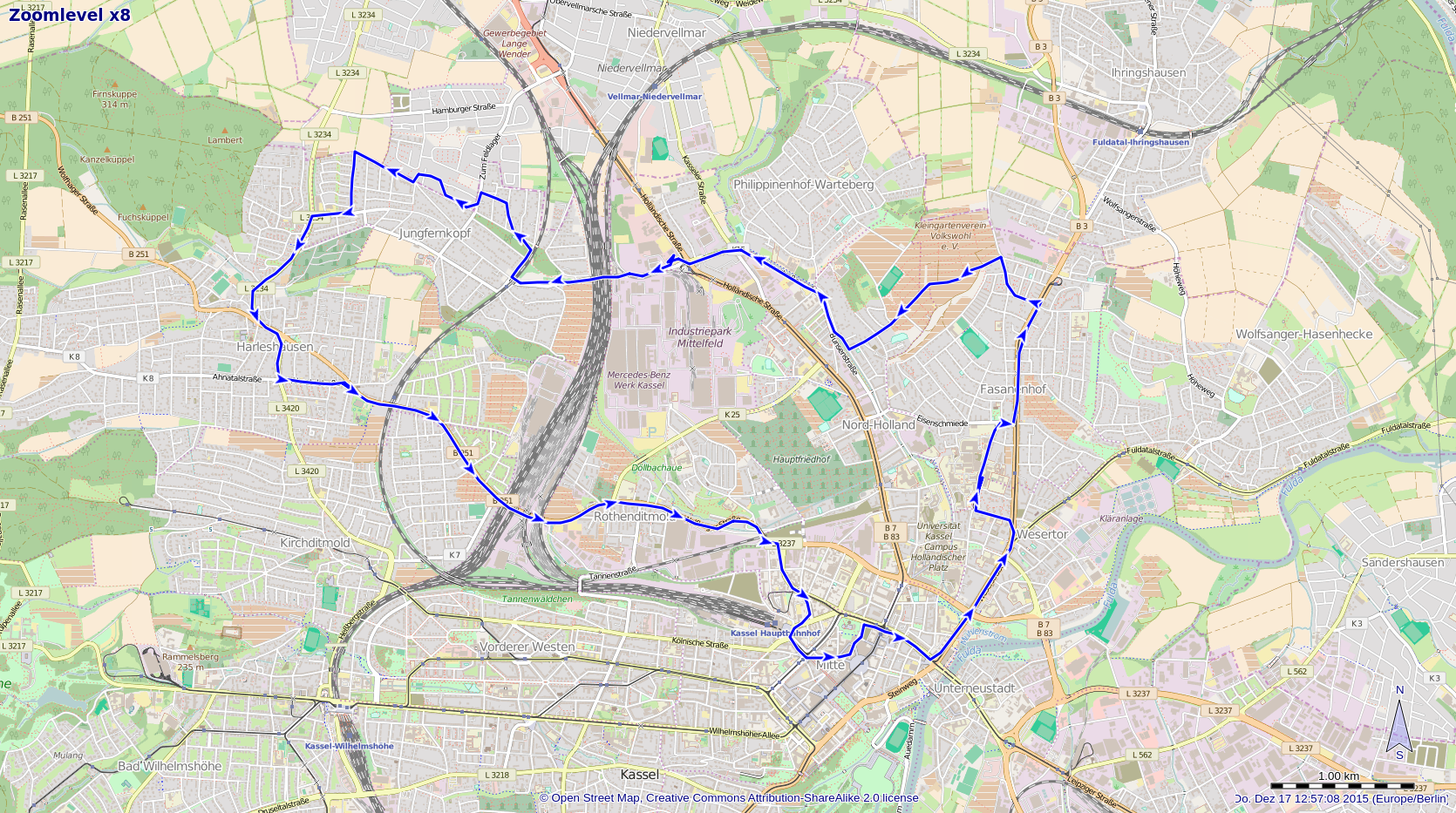
Tracklog
 |
Achievements
GeorgDerReisende earned the Walk geohash Achievement
|
GeorgDerReisende earned the Tron achievement
|