Difference between revisions of "2008-06-22 47 19"
From Geohashing
imported>Tomtom |
imported>FippeBot m (Location) |
||
| (3 intermediate revisions by 2 users not shown) | |||
| Line 7: | Line 7: | ||
| graticule_link=Budapest, Hungary | | graticule_link=Budapest, Hungary | ||
}} | }} | ||
| − | + | {| class="wikitable" style="text-align: center; vertical-align: top; border: 3px solid black; border-collapse: collapse; margin: 1em" border="1" cellpadding="2" width="350" | |
| + | !width=50%| Date | ||
| + | !width=50%| Coordinates | ||
| + | |- | ||
| + | ! {{date link|2008-06-22|D j M Y}} | ||
| + | | {{coordinates graticule|2008-06-22|lat=47|lon=19}} | ||
| + | |} | ||
==Location== | ==Location== | ||
| Line 13: | Line 19: | ||
==Expedition== | ==Expedition== | ||
| − | [[User:Tomtom| | + | [[User:Tomtom|Tom]] - I rode my bike from home to the site. (You can check out my path [http://maps.google.com/maps/ms?ie=UTF8&hl=en&msa=0&msid=111228632792916383452.00045048b54455a631242&ll=47.703293,19.188309&spn=0.130772,0.272942&t=k&z=12 here], it was a total of 63.9 km / 39.71 mi) The first part of the journey was quite easy, on bike lanes and roads, the close approach made me a bit more sweaty, with up and downhills on dirt roads. I was very much afraid of having a flat tyre because of all the thorns, burrs and thistles, but i went on the right path. |
== Pictures == | == Pictures == | ||
<gallery caption="the day of the lone rider" widths="150px" heights="150px" perrow="3"> | <gallery caption="the day of the lone rider" widths="150px" heights="150px" perrow="3"> | ||
| Line 23: | Line 29: | ||
[[Category:Expeditions]] | [[Category:Expeditions]] | ||
| − | [[Category: | + | [[Category:Expeditions with photos]] |
| + | [[Category:Coordinates reached]] | ||
| + | {{location|HU|PE}} | ||
Latest revision as of 05:24, 7 August 2019
| Sun 22 Jun 2008 in Budapest, Hungary: 47.7465293, 19.2642328 geohashing.info google osm bing/os kml crox |
| Date | Coordinates |
|---|---|
| Sun 22 Jun 2008 | 47.7465293, 19.2642328 |
Location
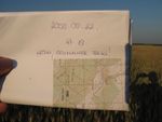
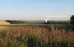
The hashpoint for the graticule was near Vác, between the villages called Váchartyán and Kisnémedi, outside residental areas, on the side of a mound among wheat, maize and rape fields, in a small forest of pines.
Expedition
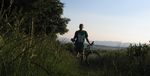
Tom - I rode my bike from home to the site. (You can check out my path here, it was a total of 63.9 km / 39.71 mi) The first part of the journey was quite easy, on bike lanes and roads, the close approach made me a bit more sweaty, with up and downhills on dirt roads. I was very much afraid of having a flat tyre because of all the thorns, burrs and thistles, but i went on the right path.
Pictures
- the day of the lone rider
approaching the hashpoint
at the site
there it is
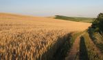
nice blonde fields around


