Difference between revisions of "2020-04-06 39 -77"
From Geohashing
([live] Going for this one, and then the one in the graticule to the east.) |
m (Location) |
||
| (3 intermediate revisions by 2 users not shown) | |||
| Line 1: | Line 1: | ||
| − | + | {{meetup graticule | |
| − | |||
| − | |||
| − | |||
| − | |||
| − | |||
| − | |||
| − | |||
| − | |||
| lat=39 | | lat=39 | ||
| lon=-77 | | lon=-77 | ||
| date=2020-04-06 | | date=2020-04-06 | ||
| − | }} | + | }} |
__NOTOC__ | __NOTOC__ | ||
== Location == | == Location == | ||
| − | + | The Geohash exists just outside of the school zone in Leesburg. | |
== Participants == | == Participants == | ||
| − | + | *[[User:OfficeLinebacker|OfficeLinebacker]] | |
| − | |||
| − | |||
| − | |||
| − | |||
== Expedition == | == Expedition == | ||
| − | |||
| − | |||
| − | |||
*Going for this one, and then the one in the graticule to the east. -- [[User:OfficeLinebacker|OfficeLinebacker]] ([[User talk:OfficeLinebacker|talk]]) 15:44, 6 April 2020 (EDT) | *Going for this one, and then the one in the graticule to the east. -- [[User:OfficeLinebacker|OfficeLinebacker]] ([[User talk:OfficeLinebacker|talk]]) 15:44, 6 April 2020 (EDT) | ||
| − | |||
| − | |||
== Photos == | == Photos == | ||
| − | |||
| − | |||
| − | |||
<gallery perrow="5"> | <gallery perrow="5"> | ||
| + | |||
| + | Image:2020-04-06_39_-77_OfficeLinebacker_1586206036420.jpg|The geocache exists just outside of the school zone, thankfully. [https://openstreetmap.org/?lat=39.10913200&lon=-77.58023020&zoom=16&layers=B000FTF @39.1091,-77.5802] | ||
| + | |||
| + | Image:2020-04-06_39_-77_OfficeLinebacker_1586206119934.jpg|Nothing like skirting the bounds of an official school zone while geohashing. [https://openstreetmap.org/?lat=39.10893480&lon=-77.58038020&zoom=16&layers=B000FTF @39.1089,-77.5804] | ||
</gallery> | </gallery> | ||
| Line 42: | Line 26: | ||
<!-- Add any achievement ribbons you earned below, or remove this section --> | <!-- Add any achievement ribbons you earned below, or remove this section --> | ||
| − | |||
| − | |||
| − | |||
| − | |||
| − | |||
| − | |||
| − | |||
| − | |||
| − | |||
| − | |||
| − | |||
| − | |||
| − | |||
| − | |||
[[Category:Expeditions]] | [[Category:Expeditions]] | ||
| − | |||
[[Category:Expeditions with photos]] | [[Category:Expeditions with photos]] | ||
| − | |||
| − | |||
| − | |||
| − | |||
| − | |||
[[Category:Coordinates reached]] | [[Category:Coordinates reached]] | ||
| − | + | {{location|US|VA|LD}} | |
| − | |||
| − | |||
| − | |||
| − | |||
| − | |||
| − | |||
| − | |||
| − | |||
| − | |||
| − | |||
| − | |||
| − | |||
| − | |||
| − | |||
| − | |||
| − | |||
| − | |||
Latest revision as of 19:43, 13 April 2020
| Mon 6 Apr 2020 in 39,-77: 39.1089358, -77.5804158 geohashing.info google osm bing/os kml crox |
Location
The Geohash exists just outside of the school zone in Leesburg.
Participants
Expedition
- Going for this one, and then the one in the graticule to the east. -- OfficeLinebacker (talk) 15:44, 6 April 2020 (EDT)
Photos
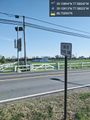
The geocache exists just outside of the school zone, thankfully. @39.1091,-77.5802

Nothing like skirting the bounds of an official school zone while geohashing. @39.1089,-77.5804

