Difference between revisions of "2014-02-08 49 8"
imported>DODO (→Expedition) |
|||
| (8 intermediate revisions by 3 users not shown) | |||
| Line 14: | Line 14: | ||
| date=2014-02-08 | | date=2014-02-08 | ||
}} | }} | ||
| − | + | [[2014-02-07_49_8|previous]] [[2014-02-21 49 8|next]] | |
<!-- edit as necessary --> | <!-- edit as necessary --> | ||
__NOTOC__ | __NOTOC__ | ||
| Line 28: | Line 28: | ||
== Plans == | == Plans == | ||
<!-- what were the original plans --> | <!-- what were the original plans --> | ||
| − | + | I will be less than 3 KM away from the hashpoint at 4 pm but sitting in a boat I can't make it there. Nevertheless, I 'll come along an hour later or two on my way back home. ( [[User:DODO|DODO]]) | |
== Expedition == | == Expedition == | ||
<!-- how it all turned out. your narrative goes here. --> | <!-- how it all turned out. your narrative goes here. --> | ||
| − | When I left home today I paid attention not to forget my hashbag as I did [[2014-02-07_49_8|yesterday]]. And so, little DODO, PAGO and I went to the rowing club in Mannheim-Rheinau for the first time together. As expected, I came pretty close to the hash from there (in the middle of the Otterstädter Altrhein in front of the Leberwurstinsel), but with al the rain I couldn't persuade my fellows to row just a little bit further and then run through some muddy fields and | + | When I left home today I paid attention not to forget my hashbag as I did [[2014-02-07_49_8|yesterday]]. And so, little DODO, PAGO and I went to the rowing club in Mannheim-Rheinau for the first time together. As expected, I came pretty close to the hash from there (in the middle of the Otterstädter Altrhein in front of the Leberwurstinsel), but with al the rain I couldn't persuade my fellows to row just a little bit further and then run through some muddy fields and having fun at a hashpoint. For my consolation someone brought some cake. |
| + | |||
| + | So I had to come along the hashpoint during my way back home. For this I had to cross the river rhine, and I chose the ferry at Altrip to do so. From there it was just a short drive through Altrip and Waldsee, a stop in the middle of nowhere and a 45 m walk; well 25 m along the path, 15 m along a trench between two fields and 5 m into a ploughed field in the rain. Long enough to switch my shoes into something incommensurate for cars. | ||
Not much to tell there: a view to Otterstadt, one to the street and to my small car to which I hurried back and drove home after little DODO left his (very little) egg. | Not much to tell there: a view to Otterstadt, one to the street and to my small car to which I hurried back and drove home after little DODO left his (very little) egg. | ||
| Line 39: | Line 41: | ||
== Tracklog == | == Tracklog == | ||
<!-- if your GPS device keeps a log, you may post a link here --> | <!-- if your GPS device keeps a log, you may post a link here --> | ||
| + | [http://www.gpsies.com/map.do?fileId=gvvxvqfdqqtmmyxe little car: 47 KM (instead of 52)] | ||
== Photos == | == Photos == | ||
| Line 45: | Line 48: | ||
--> | --> | ||
<gallery perrow="5"> | <gallery perrow="5"> | ||
| + | Image:2014-02-08_49_8-1.jpg|rowing | ||
| + | Image:2014-02-08_49_8-2.jpg|refreshment | ||
| + | Image:2014-02-08_49_8-3.jpg|ferry | ||
| + | Image:2014-02-08_49_8-5.jpg|view from the hashpoint | ||
| + | Image:2014-02-08_49_8-6.jpg|little car seen from the hashpoint | ||
| + | Image:2014-02-08_49_8-7.jpg|big DODO with mad grin | ||
| + | Image:2014-02-08_49_8-8.jpg|little dodo with xkcdodo egg | ||
</gallery> | </gallery> | ||
| Line 50: | Line 60: | ||
{{#vardefine:ribbonwidth|800px}} | {{#vardefine:ribbonwidth|800px}} | ||
<!-- Add any achievement ribbons you earned below, or remove this section --> | <!-- Add any achievement ribbons you earned below, or remove this section --> | ||
| + | {{land geohash | ||
| + | | latitude = 49 | ||
| + | | longitude = 8 | ||
| + | | date = 2014-02-03 | ||
| + | | name = DODO | ||
| + | | image = 2014-02-03_49_8-3.jpg | ||
| + | }} | ||
<!-- =============== USEFUL CATEGORIES FOLLOW ================ | <!-- =============== USEFUL CATEGORIES FOLLOW ================ | ||
Delete the next line ONLY if you have chosen the appropriate categories below. If you are unsure, don't worry. People will read your report and help you with the classification. --> | Delete the next line ONLY if you have chosen the appropriate categories below. If you are unsure, don't worry. People will read your report and help you with the classification. --> | ||
| − | |||
<!-- Potential categories. Please include all the ones appropriate to your expedition --> | <!-- Potential categories. Please include all the ones appropriate to your expedition --> | ||
| Line 61: | Line 77: | ||
--> | --> | ||
| − | |||
[[Category:Expeditions]] | [[Category:Expeditions]] | ||
| − | |||
[[Category:Expeditions with photos]] | [[Category:Expeditions with photos]] | ||
| − | |||
| − | |||
| − | |||
| − | |||
[[Category:Coordinates reached]] | [[Category:Coordinates reached]] | ||
| − | + | {{location|DE|RP|RP}} | |
| − | |||
| − | |||
| − | |||
| − | |||
| − | |||
| − | |||
| − | |||
| − | |||
| − | |||
| − | |||
| − | |||
| − | |||
| − | |||
| − | |||
| − | |||
| − | |||
| − | |||
Latest revision as of 10:54, 23 April 2020
| Sat 8 Feb 2014 in 49,8: 49.3773098, 8.4367099 geohashing.info google osm bing/os kml crox |
Location
In a field near Otterstadt
Participants
Plans
I will be less than 3 KM away from the hashpoint at 4 pm but sitting in a boat I can't make it there. Nevertheless, I 'll come along an hour later or two on my way back home. ( DODO)
Expedition
When I left home today I paid attention not to forget my hashbag as I did yesterday. And so, little DODO, PAGO and I went to the rowing club in Mannheim-Rheinau for the first time together. As expected, I came pretty close to the hash from there (in the middle of the Otterstädter Altrhein in front of the Leberwurstinsel), but with al the rain I couldn't persuade my fellows to row just a little bit further and then run through some muddy fields and having fun at a hashpoint. For my consolation someone brought some cake.
So I had to come along the hashpoint during my way back home. For this I had to cross the river rhine, and I chose the ferry at Altrip to do so. From there it was just a short drive through Altrip and Waldsee, a stop in the middle of nowhere and a 45 m walk; well 25 m along the path, 15 m along a trench between two fields and 5 m into a ploughed field in the rain. Long enough to switch my shoes into something incommensurate for cars. Not much to tell there: a view to Otterstadt, one to the street and to my small car to which I hurried back and drove home after little DODO left his (very little) egg.
A "nearly tron", an invalid autobahn-exit, the dead-ended road at the rowing club and the way from the car to the hashpoint itself. But the people from the internet are severe.
Tracklog
little car: 47 KM (instead of 52)
Photos
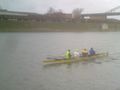
rowing
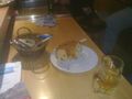
refreshment
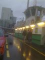
ferry
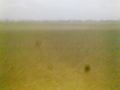
view from the hashpoint
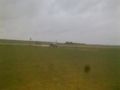
little car seen from the hashpoint

big DODO with mad grin
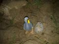
little dodo with xkcdodo egg


Achievements
DODO earned the Land geohash achievement
|