Difference between revisions of "2014-02-28 45 -122"
From Geohashing
imported>Zhukant (Created page with "{{subst:Expedition |lat = 45 |lon = -122 |date = 2014-02-28 }}") |
m (Location correction) |
||
| (4 intermediate revisions by 3 users not shown) | |||
| Line 1: | Line 1: | ||
| + | [[Image:{{{image|2014-02-28 45 -122 C.jpg}}}|thumb|left]] | ||
| − | |||
| − | |||
| − | |||
| − | |||
| − | |||
| − | |||
| − | |||
| − | |||
| − | |||
{{meetup graticule | {{meetup graticule | ||
| lat=45 | | lat=45 | ||
| Line 14: | Line 6: | ||
| date=2014-02-28 | | date=2014-02-28 | ||
}} | }} | ||
| − | + | A thwarted expedition in [[Portland, Oregon|Portland]] on Friday, Feb 28, 2014. | |
| − | |||
__NOTOC__ | __NOTOC__ | ||
== Location == | == Location == | ||
| − | + | On the territory of a nursery farm in the northwest corner of Damascus, Oregon. | |
== Participants == | == Participants == | ||
| − | + | *[[User:Zhukant|zhukant]] | |
| − | + | *[[User:TachiTaylor|TachiTaylor]] | |
| − | |||
| − | |||
| − | |||
== Expedition == | == Expedition == | ||
| − | + | We drove out on the road that would get us closest to the hashpoint, but found a neatly placed gate and chain link fence with a polite sign proclaiming that the gate shall be locked at all times. We took some photos of the sign and the cute purple padlock with our [[hashscot]] Scout, then seeing that no other approach remains that may get us any closer, we departed. | |
| − | |||
| − | |||
| − | |||
== Photos == | == Photos == | ||
| − | |||
| − | |||
| − | |||
<gallery perrow="5"> | <gallery perrow="5"> | ||
| + | Image:2014-02-28 45 -122 A.jpg | zhukant getting out of the car. | ||
| + | |||
| + | Image:2014-02-28 45 -122 B.jpg | zhukant's Stupid Grin (tm) and Scout. | ||
</gallery> | </gallery> | ||
== Achievements == | == Achievements == | ||
{{#vardefine:ribbonwidth|800px}} | {{#vardefine:ribbonwidth|800px}} | ||
| − | + | {{No trespassing | |
| − | + | | latitude = 45 | |
| − | + | | longitude = -122 | |
| − | + | | date = 2014-02-28 | |
| − | + | | name = TachiTaylor and zhukant | |
| − | + | }} | |
| − | |||
| − | |||
| − | |||
| − | |||
| − | |||
| − | |||
| − | |||
| − | |||
[[Category:Expeditions]] | [[Category:Expeditions]] | ||
| − | |||
[[Category:Expeditions with photos]] | [[Category:Expeditions with photos]] | ||
| − | |||
| − | |||
| − | |||
| − | |||
| − | |||
| − | |||
| − | |||
| − | |||
| − | |||
[[Category:Coordinates not reached]] | [[Category:Coordinates not reached]] | ||
| − | |||
| − | |||
| − | |||
| − | |||
| − | |||
[[Category:Not reached - No public access]] | [[Category:Not reached - No public access]] | ||
| − | + | {{location|US|OR|CC}} | |
| − | |||
| − | |||
| − | |||
| − | |||
| − | |||
| − | |||
| − | |||
Latest revision as of 20:22, 16 May 2020

| Fri 28 Feb 2014 in 45,-122: 45.4564359, -122.4701682 geohashing.info google osm bing/os kml crox |
A thwarted expedition in Portland on Friday, Feb 28, 2014.
Location
On the territory of a nursery farm in the northwest corner of Damascus, Oregon.
Participants
Expedition
We drove out on the road that would get us closest to the hashpoint, but found a neatly placed gate and chain link fence with a polite sign proclaiming that the gate shall be locked at all times. We took some photos of the sign and the cute purple padlock with our hashscot Scout, then seeing that no other approach remains that may get us any closer, we departed.
Photos
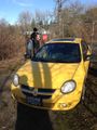
zhukant getting out of the car.
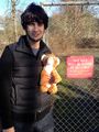
zhukant's Stupid Grin (tm) and Scout.


Achievements
TachiTaylor and zhukant earned the No trespassing consolation prize
|