Difference between revisions of "2016-06-09 51 3"
imported>FelixTheCat (Created page with "{{subst:Expedition |lat = 51 |lon = 3 |date = 2016-06-09 }}") |
m (Location correction) |
||
| (3 intermediate revisions by 2 users not shown) | |||
| Line 1: | Line 1: | ||
| − | |||
| − | |||
| − | |||
| − | |||
| − | |||
| − | |||
| − | |||
| − | |||
| − | |||
| − | |||
{{meetup graticule | {{meetup graticule | ||
| lat=51 | | lat=51 | ||
| Line 14: | Line 4: | ||
| date=2016-06-09 | | date=2016-06-09 | ||
}} | }} | ||
| − | |||
| − | |||
__NOTOC__ | __NOTOC__ | ||
== Location == | == Location == | ||
| − | + | Overslag, municipality of Terneuzen, Zeeland province. | |
== Participants == | == Participants == | ||
| − | + | [[User:FelixTheCat|FelixTheCat]] ([[User talk:FelixTheCat|talk]]) | |
| − | |||
== Plans == | == Plans == | ||
| − | + | Drive towards the hash and find out if it's accessible. | |
== Expedition == | == Expedition == | ||
| − | + | The hash appeared to be very close to the Dutch-Belgian border. Although it was located on Dutch territory (belonging to the village of Overslag), it was really only accessible through a Belgian road (in the town of Moerbeke). After parking my car by the side of the road I walked the last 250 metres to the hash, next to a small lake that seemed to be a popular fishing spot (with Belgians, because the lake was in Belgium). The hash turned out to be located inside a (Dutch) reed bed, so the last 50 metres were quite difficult to walk. With the ground below me becoming wetter and wetter I was afraid I'd end up with the My Kingdom for a Boat prize [[2016-05-26 52 4|again]], but luckily the final location was still on terra firma. | |
| − | + | Although the hash was located in the Netherlands, it was really only accessible from Belgium, so I did have to cross a border to reach it. In fact, I must have crossed the border several times while walking around in the area, so I guess I should have earned the Border Geohash with this one. Just to give it a bit more weight, I've included several pictures of the actual border :-) | |
| − | |||
== Photos == | == Photos == | ||
| − | |||
| − | |||
| − | |||
<gallery perrow="5"> | <gallery perrow="5"> | ||
| + | Image:2016-06-09 51 3 FelixTheCat 1.JPG | The (Belgian) road leading towards the hash. | ||
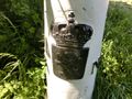
| + | Image:2016-06-09 51 3 FelixTheCat 2.JPG | Border marker number 296. The hash is somewhere in the background. | ||
| + | Image:2016-06-09 51 3 FelixTheCat 3.JPG | Somewhere in here, that is. Hope it's dry... | ||
| + | Image:2016-06-09 51 3 FelixTheCat 4.JPG | Yes, I can still stand without getting my feet wet! | ||
| + | Image:2016-06-09 51 3 FelixTheCat 5.JPG | Lloyd didn't want to risk sitting on the ground. | ||
| + | Image:2016-06-09 51 3 FelixTheCat 6.png | Proof. Note how we're literally in a remote corner of the Netherlands. | ||
| + | Image:2016-06-09 51 3 FelixTheCat 7.JPG | The Belgian coat of arms on the border marker. | ||
| + | Image:2016-06-09 51 3 FelixTheCat 8.JPG | The Dutch coat of arms (which I never realized was so similar to the Belgian one). | ||
| + | Image:2016-06-09 51 3 FelixTheCat 9.JPG | Crossing back into the Netherlands about 1 km down the road. Note the break in pavement types and road markings (centre line in Belgium, edge lines in the Netherlands). | ||
</gallery> | </gallery> | ||
== Achievements == | == Achievements == | ||
{{#vardefine:ribbonwidth|800px}} | {{#vardefine:ribbonwidth|800px}} | ||
| − | + | {{Border geohash achievement | |
| − | |||
| − | |||
| − | |||
| − | |||
| − | |||
| − | |||
| − | + | | latitude = 51 | |
| − | + | | longitude = 3 | |
| − | [[ | + | | date = 2016-06-09 |
| − | + | | country1 = Netherlands | |
| + | | country2 = Belgium | ||
| + | | name = [[User:FelixTheCat|FelixTheCat]] ([[User talk:FelixTheCat|talk]]) | ||
| + | }} | ||
| − | |||
| − | |||
| − | |||
[[Category:Expeditions]] | [[Category:Expeditions]] | ||
| − | |||
[[Category:Expeditions with photos]] | [[Category:Expeditions with photos]] | ||
| − | |||
| − | |||
| − | |||
| − | |||
| − | |||
[[Category:Coordinates reached]] | [[Category:Coordinates reached]] | ||
| − | + | {{location|NL|ZE}} | |
| − | |||
| − | |||
| − | |||
| − | |||
| − | |||
| − | |||
| − | |||
| − | |||
| − | |||
| − | |||
| − | |||
| − | |||
| − | |||
| − | |||
| − | |||
| − | |||
| − | |||
Latest revision as of 20:33, 16 May 2020
| Thu 9 Jun 2016 in 51,3: 51.2080959, 3.9182043 geohashing.info google osm bing/os kml crox |
Location
Overslag, municipality of Terneuzen, Zeeland province.
Participants
Plans
Drive towards the hash and find out if it's accessible.
Expedition
The hash appeared to be very close to the Dutch-Belgian border. Although it was located on Dutch territory (belonging to the village of Overslag), it was really only accessible through a Belgian road (in the town of Moerbeke). After parking my car by the side of the road I walked the last 250 metres to the hash, next to a small lake that seemed to be a popular fishing spot (with Belgians, because the lake was in Belgium). The hash turned out to be located inside a (Dutch) reed bed, so the last 50 metres were quite difficult to walk. With the ground below me becoming wetter and wetter I was afraid I'd end up with the My Kingdom for a Boat prize again, but luckily the final location was still on terra firma.
Although the hash was located in the Netherlands, it was really only accessible from Belgium, so I did have to cross a border to reach it. In fact, I must have crossed the border several times while walking around in the area, so I guess I should have earned the Border Geohash with this one. Just to give it a bit more weight, I've included several pictures of the actual border :-)
Photos
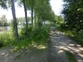
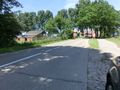
The (Belgian) road leading towards the hash.
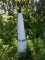
Border marker number 296. The hash is somewhere in the background.
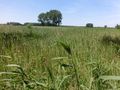
Somewhere in here, that is. Hope it's dry...
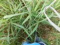
Yes, I can still stand without getting my feet wet!
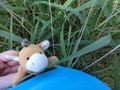
Lloyd didn't want to risk sitting on the ground.
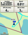
Proof. Note how we're literally in a remote corner of the Netherlands.
The Belgian coat of arms on the border marker.
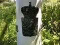
The Dutch coat of arms (which I never realized was so similar to the Belgian one).
Crossing back into the Netherlands about 1 km down the road. Note the break in pavement types and road markings (centre line in Belgium, edge lines in the Netherlands).


Achievements
FelixTheCat (talk) earned the Border geohash achievement
|