Difference between revisions of "2019-01-15 50 8"
From Geohashing
imported>Mampfred |
m (Location correction) |
||
| (3 intermediate revisions by 2 users not shown) | |||
| Line 15: | Line 15: | ||
* [[User:LadyBB|LadyBB]] | * [[User:LadyBB|LadyBB]] | ||
* [[User:EmmJay|EmmJay]] | * [[User:EmmJay|EmmJay]] | ||
| + | * [[User:QuarterCacher|QuarterCacher]] | ||
== Plans == | == Plans == | ||
| Line 20: | Line 21: | ||
== Expedition == | == Expedition == | ||
| − | + | Kid got back late so we started around 4pm. Very straight forward hash as it was fairly close to where we live and we know the area very well so we immediately knew what path to take. [[User:Mampfred|Mampfred]], [[User:LadyBB|LadyBB]] and [[User:EmmJay|EmmJay]] got to the hash around 4:30pm, coordinates reached. | |
| + | |||
| + | Unfortunately [[User:QuarterCacher|QuarterCacher]] had plans preventing him from joining the first expedition so he and [[User:Mampfred|Mampfred]] started a second expedition at 5:15pm, another coordinated reached (again!). | ||
| + | |||
| + | Feels good to be hashing again :) | ||
== Tracklog == | == Tracklog == | ||
| − | + | See [https://www.alltrails.com/explore/recording/geohashing-2019-01-15-50-8 here]. | |
== Photos == | == Photos == | ||
| − | |||
| − | |||
| − | |||
<gallery perrow="5"> | <gallery perrow="5"> | ||
| + | Image:2019-01-15_50_8_how_deep_is_that.jpg | Can I jump in that? | ||
| + | Image:2019-01-15_50_8_hash_dance.jpg | Hash Dance | ||
| + | Image:2019-01-15_50_8_coordinates_reached.jpg | Coordinates reached! | ||
| + | Image:2019-01-15_50_8_stupid_grin_1.jpg | Stupid grin for expedition 1 | ||
| + | Image:2019-01-15_50_8_stupid_grin_2.jpg | Stupid grin for expedition 2 | ||
</gallery> | </gallery> | ||
| Line 35: | Line 42: | ||
{{#vardefine:ribbonwidth|800px}} | {{#vardefine:ribbonwidth|800px}} | ||
| − | |||
| − | |||
| − | |||
| − | |||
| − | |||
| − | |||
[[Category:Expeditions]] | [[Category:Expeditions]] | ||
| − | |||
[[Category:Expeditions with photos]] | [[Category:Expeditions with photos]] | ||
| − | |||
| − | |||
| − | |||
| − | |||
| − | |||
| − | |||
| − | |||
[[Category:Coordinates reached]] | [[Category:Coordinates reached]] | ||
| − | + | {{location|DE|HE|SWA}} | |
| − | |||
| − | |||
| − | |||
| − | |||
| − | |||
| − | |||
| − | |||
| − | |||
| − | |||
| − | |||
| − | |||
| − | |||
| − | |||
| − | |||
| − | |||
| − | |||
| − | |||
Latest revision as of 20:39, 16 May 2020
| Tue 15 Jan 2019 in 50,8: 50.1855259, 8.3488953 geohashing.info google osm bing/os kml crox |
Location
Not far from our home on a path in the woods.
Participants
Plans
Go there later today when the kid is back from school.
Expedition
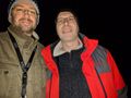
Kid got back late so we started around 4pm. Very straight forward hash as it was fairly close to where we live and we know the area very well so we immediately knew what path to take. Mampfred, LadyBB and EmmJay got to the hash around 4:30pm, coordinates reached.
Unfortunately QuarterCacher had plans preventing him from joining the first expedition so he and Mampfred started a second expedition at 5:15pm, another coordinated reached (again!).
Feels good to be hashing again :)
Tracklog
See here.
Photos
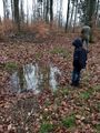
Can I jump in that?
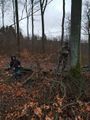
Hash Dance
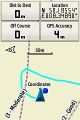
Coordinates reached!
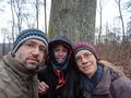
Stupid grin for expedition 1
Stupid grin for expedition 2


