Difference between revisions of "2019-01-27 51 9"
imported>Digiphono (Created page with "{{meetup graticule | lat=51 | lon=9 | date=2019-01-27 }} __NOTOC__ == Location == In a forest south of Nörten-Hardenberg. == Participants == [[User:Digiphono|Digiphono]...") |
m (Location correction) |
||
| (One intermediate revision by one other user not shown) | |||
| Line 39: | Line 39: | ||
[[Category:Expeditions with photos]] | [[Category:Expeditions with photos]] | ||
[[Category:Coordinates reached]] | [[Category:Coordinates reached]] | ||
| + | {{location|DE|NI|NOM}} | ||
Latest revision as of 22:45, 22 May 2020
| Sun 27 Jan 2019 in 51,9: 51.6217799, 9.9507160 geohashing.info google osm bing/os kml crox |
Location
In a forest south of Nörten-Hardenberg.
Participants
Plans
To do some walking near Nörten-Hardenberg and also catch the hash...
Expedition
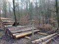
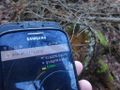
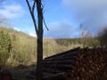
After a couple of frozen days, the temperatures were above zero again and even if there was a lot of snow during night, it all disappeared today, with some 7 degrees. So, with a little bit of rain, I drove to Nörten-Hardenberg to do a medium hike of 8 kilometers through the forest, along the Bielstein-Road, a nice road through an even nicer forest. Right at the beginning, only 100 meters from the parking lot, there was today's hash, so I started my journey with this one and managed to locate the hash within a few minutes. It was only 15 meters off the main path, and I managed to get an accuracy of less than one meter on this one, a tree stump...
Nothing more to say about this hash - I did a nice walk after visiting the hash and got back home 16:00 pm.
Photos
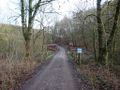
The way to the hash
The Bielsteinstraße
The hash - proof
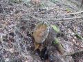
The hash was this tree stump
The hash - screenshot
Nice view near the hash


