Difference between revisions of "2010-01-13 -37 145"
imported>Kozz |
m (More specific location) |
||
| (9 intermediate revisions by 4 users not shown) | |||
| Line 1: | Line 1: | ||
| − | |||
| − | |||
| − | |||
| − | |||
| − | |||
| − | |||
{{meetup graticule | {{meetup graticule | ||
| lat=-37 | | lat=-37 | ||
| Line 11: | Line 5: | ||
}} | }} | ||
| − | |||
__NOTOC__ | __NOTOC__ | ||
== Location == | == Location == | ||
| Line 22: | Line 15: | ||
== Plans == | == Plans == | ||
| − | [[user kozz|Kozz]] will drive from home and back during lunch hour. | + | [[user:kozz|Kozz]] will drive from home and back during lunch hour. |
| + | |||
| + | |||
| + | [[User:MykaDragonBlue|myka]] intended to go, but discovered an indicator on his car was out, and had to spend time diagnosing that... and discovering he would need parts to fix it.. hence he couldn't really drive to the hash. (bike needs some attention as well, and the time was all wrong for it when he was free) | ||
== Expedition == | == Expedition == | ||
| Line 28: | Line 24: | ||
The East Melbourne graticulate has been pumping out achievable geohashes for most of January; unfortunately work and life get in the way of my favourite randomly-generated-coordinate-based-adventure pastime. Yesterday, for instance, I would have gladly driven the 50 minutes from home to the hash point close to Sugarloaf Reservoir if it were not for those tyrannical people who dare to provide me with gainful employment. Not helped, of course, by searing 40-degree-celsius heat. Is there a Roasted Geohash award? | The East Melbourne graticulate has been pumping out achievable geohashes for most of January; unfortunately work and life get in the way of my favourite randomly-generated-coordinate-based-adventure pastime. Yesterday, for instance, I would have gladly driven the 50 minutes from home to the hash point close to Sugarloaf Reservoir if it were not for those tyrannical people who dare to provide me with gainful employment. Not helped, of course, by searing 40-degree-celsius heat. Is there a Roasted Geohash award? | ||
| − | Today's hash looked reasonably familiar, and quite close by within 20 minutes of my house, and I'm working from home - bingo! Lunch break geohash! | + | Today's hash looked reasonably familiar, and quite close by within 20 minutes of my house, and I'm working from home - bingo! Lunch break geohash! |
| − | + | I recently purchased a cheap handheld GPS with the hope of being able to actually find my way to the point using a compass and distance markers rather than by dead reckoning by satnav. The hash point on Google Maps was easily identifiable by a massive tree, so would have no particular issue matching up GPS display with reality. | |
| − | I fired up the GPS which took ages to find satellites then told me to travel 6480m south-west. This would put me about neck-deep in the waters of St Kilda Beach, so I chose to ignore these instructions and wandered around on foot, trying to find the exact point by dead reckoning. This didn't work, so in frustration I reset the device, then rebooted and readded the coordinates. To my surprise, it popped up with directions, distances and instructions immediately and lead me directly to the point shown on Google Earth. Win! | + | The faithful dog accompanied me in the car on the way to Nettleton Park, and when we arrived I realised why it looked familiar - there are a set of brilliant public bike trails that trace Gardener's Creek in the Eastern Suburbs all the way into the main Yarra River Trail. Nettleton Park was just off to one side of the bike trail. I've probably cycled up and down this part of the trail three or four times - not close enough, nor recently enough, to count as a Deja Vu. |
| + | |||
| + | I fired up the GPS which took ages to find satellites then told me to travel 6480m south-west. This would put me about neck-deep in the waters of St Kilda Beach, so I chose to ignore these instructions and wandered around on foot, trying to find the exact point by dead reckoning. This didn't work, so in frustration I reset the device, then rebooted and readded the coordinates. To my surprise, it popped up with directions, distances and instructions immediately and lead me directly to the point pretty much perfectly in the same spot as shown on Google Earth. Win! | ||
I took the obligatory photos, let the dog go for a bit of a run - it's an off-lead park - then jumped back in the car and headed back home. All in all, 49 minutes away from the house. Back to work. | I took the obligatory photos, let the dog go for a bit of a run - it's an off-lead park - then jumped back in the car and headed back home. All in all, 49 minutes away from the house. Back to work. | ||
| − | |||
| − | |||
| − | |||
== Photos == | == Photos == | ||
| − | |||
<gallery perrow="4"> | <gallery perrow="4"> | ||
| − | Image: | + | Image:2010-01-13_-37_145_Approach.jpg | Approach to the hash point |
| − | Image: | + | Image:2010-01-13_-37_145_Bike trail.JPG | Nearby Gardiner's Creek bike trail |
| + | Image:2010-01-13_-37_145_Creek.JPG | Nearby Gardiner's Creek | ||
| + | Image:2010-01-13_-37_145_hash point for real.JPG | Finally the GPS works! | ||
| + | Image:2010-01-13_-37_145_Hash point kinda.JPG | Hash point as advised by GPS | ||
| + | Image:2010-01-13_-37_145_hello satellite.JPG | Looking up at the satellites. Hello satellites! | ||
| + | Image:2010-01-13_-37_145_nettleton park.JPG | Nettleton Park - no nettles though | ||
| + | Image:2010-01-13_-37_145_Path.JPG | Path leading away from the hash point | ||
</gallery> | </gallery> | ||
| − | |||
| − | |||
| − | |||
| − | |||
| − | |||
| − | |||
| − | |||
| − | |||
| − | |||
| − | |||
| − | |||
[[Category:Expeditions]] | [[Category:Expeditions]] | ||
| − | |||
[[Category:Expeditions with photos]] | [[Category:Expeditions with photos]] | ||
| − | |||
| − | |||
| − | |||
| − | |||
| − | |||
[[Category:Coordinates reached]] | [[Category:Coordinates reached]] | ||
| − | + | {{location|AU|VIC|BO}} | |
| − | |||
| − | |||
| − | |||
| − | |||
| − | |||
| − | |||
| − | |||
| − | |||
| − | |||
Latest revision as of 11:54, 1 August 2020
| Wed 13 Jan 2010 in -37,145: -37.8536578, 145.0579318 geohashing.info google osm bing/os kml crox |
Location
Nettleton Reserve, next to Gardiner's Creek, close to the Monash Freeway, Glen Iris
Participants
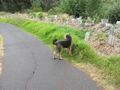
Kozz's dog
Plans
Kozz will drive from home and back during lunch hour.
myka intended to go, but discovered an indicator on his car was out, and had to spend time diagnosing that... and discovering he would need parts to fix it.. hence he couldn't really drive to the hash. (bike needs some attention as well, and the time was all wrong for it when he was free)
Expedition
kozz The East Melbourne graticulate has been pumping out achievable geohashes for most of January; unfortunately work and life get in the way of my favourite randomly-generated-coordinate-based-adventure pastime. Yesterday, for instance, I would have gladly driven the 50 minutes from home to the hash point close to Sugarloaf Reservoir if it were not for those tyrannical people who dare to provide me with gainful employment. Not helped, of course, by searing 40-degree-celsius heat. Is there a Roasted Geohash award?
Today's hash looked reasonably familiar, and quite close by within 20 minutes of my house, and I'm working from home - bingo! Lunch break geohash!
I recently purchased a cheap handheld GPS with the hope of being able to actually find my way to the point using a compass and distance markers rather than by dead reckoning by satnav. The hash point on Google Maps was easily identifiable by a massive tree, so would have no particular issue matching up GPS display with reality.
The faithful dog accompanied me in the car on the way to Nettleton Park, and when we arrived I realised why it looked familiar - there are a set of brilliant public bike trails that trace Gardener's Creek in the Eastern Suburbs all the way into the main Yarra River Trail. Nettleton Park was just off to one side of the bike trail. I've probably cycled up and down this part of the trail three or four times - not close enough, nor recently enough, to count as a Deja Vu.
I fired up the GPS which took ages to find satellites then told me to travel 6480m south-west. This would put me about neck-deep in the waters of St Kilda Beach, so I chose to ignore these instructions and wandered around on foot, trying to find the exact point by dead reckoning. This didn't work, so in frustration I reset the device, then rebooted and readded the coordinates. To my surprise, it popped up with directions, distances and instructions immediately and lead me directly to the point pretty much perfectly in the same spot as shown on Google Earth. Win!
I took the obligatory photos, let the dog go for a bit of a run - it's an off-lead park - then jumped back in the car and headed back home. All in all, 49 minutes away from the house. Back to work.
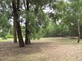
Photos
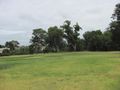
Approach to the hash point
Nearby Gardiner's Creek bike trail
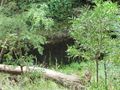
Nearby Gardiner's Creek
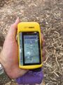
Finally the GPS works!
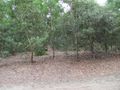
Hash point as advised by GPS
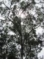
Looking up at the satellites. Hello satellites!
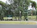
Nettleton Park - no nettles though
Path leading away from the hash point


