Difference between revisions of "2010-03-20 -37 145"
imported>Kozz |
m (More specific location) |
||
| (7 intermediate revisions by 3 users not shown) | |||
| Line 14: | Line 14: | ||
__NOTOC__ | __NOTOC__ | ||
== Location == | == Location == | ||
| − | 20m or so off the | + | 20m or so off the Old Kinglake Road in the Kinglake National Park |
== Participants == | == Participants == | ||
| − | [[user:Kozz|Kozz]] | + | [[user:Kozz|Kozz]]<br/> |
| + | [[user:Kozz|Kozz]]'s partner<br/> | ||
| + | [[user:Kozz|Kozz]]'s dog<br/> | ||
== Plans == | == Plans == | ||
| Line 23: | Line 25: | ||
== Expedition == | == Expedition == | ||
| − | + | We spent most of this morning and early afternoon doing chores, and were totally over it by mid-afternoon. I took a quick look through [[user:Ekorren|Ekorren]]'s Anthill hash calculator and saw there was a relatively nearby hashpoint, which in turn was reasonably close to an [[2010-03-08 -37 145 | early hash]] in the Yarra Valley. | |
| − | + | We plotted the course, again taking us up through the Black Saturday-affected fires, and jumped in the car with the dog. The drive was awesome again, through beautifully contoured countryside in Warrandyte, where rich people with great big estates live. | |
| − | + | ||
| + | Close to the hash in the Kinglake park, it became really really apparent that the fires had gone through the area with a vengeance. Even with the regrowth and undergrowth all around, the trees still look like someone dropped bombs on the area. | ||
| + | |||
| + | We pulled up to the entrance to the Old Kinglake Road, which is actually a track with no vehicular access. The Garmin told us we'd need to walk roughly 1.3km to the hashpoint, so we set off down the track, admiring the beautiful scenery around, including the regrowth, grass trees, ferns, and undergrowth. It made an incredible contrast against the charred trunks of the dead trees. | ||
| + | |||
| + | The hashpoint was under 10m from the road, which kinda counted, but there was easy access to the actual point proper without affecting plant life, so I walked to the point (within 38cm) and took photos. There was some fused glass nearby - presumably from the fires - plus lots of burnt sticks lying around. I left a hashmarker, took photos, then we wandered back up the hill and went home. | ||
== Photos == | == Photos == | ||
| − | |||
| − | |||
| − | |||
<gallery perrow="4"> | <gallery perrow="4"> | ||
| + | Image:2010-03-20-0749.JPG | Driving through burnt forests | ||
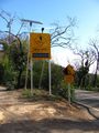
| + | Image:2010-03-20-0756.JPG | Bushfire recovery warning signs | ||
| + | Image:2010-03-20-0804.JPG | The trail in | ||
| + | Image:2010-03-20-0760.JPG | 1.3km down this track | ||
| + | Image:2010-03-20-0761.JPG | Bushfire scars | ||
| + | Image:2010-03-20-0762.JPG | Grass tree | ||
| + | Image:2010-03-20-0763.JPG | Kozz's dog is awesome | ||
| + | Image:2010-03-20-0764.JPG | Regrowth closeup | ||
| + | Image:2010-03-20-0768.JPG | Steep drop-off | ||
| + | Image:2010-03-20-0769.JPG | Beautiful regrowth | ||
| + | Image:2010-03-20-0771.JPG | 190m to go | ||
| + | Image:2010-03-20-0772.JPG | Much steeper | ||
| + | Image:2010-03-20-0776.JPG | Within the circle but on the path | ||
| + | Image:2010-03-20-0777.JPG | Hashpoint thataway | ||
| + | Image:2010-03-20-0781.JPG | Very close | ||
| + | Image:2010-03-20-0785.JPG | On the spot | ||
| + | Image:2010-03-20-0791.JPG | The hashpoint | ||
| + | Image:2010-03-20-0795.JPG | Marker goodness | ||
| + | Image:2010-03-20-0796.JPG | Molten glass | ||
| + | Image:2010-03-20-0797.JPG | Hills | ||
| + | Image:2010-03-20-0798.JPG | Pretty flowers | ||
| + | Image:2010-03-20-0799.JPG | Anthill - thanks Ekorren! | ||
| + | Image:2010-03-20-0800.JPG | Warnings on the road out | ||
| + | Image:2010-03-20-0805.JPG | Hashpoint is on public territory | ||
| + | Image:2010-03-20-0806.JPG | Raptor wounds | ||
| + | Image:2010-03-20-Hashpoint-pano.jpg | Hashpoint pano | ||
| + | Image:2010-03-20-pano.jpg | Burnt trees pano | ||
| + | |||
</gallery> | </gallery> | ||
| + | {{Velociraptor geohash | ||
| + | | latitude = -37 | ||
| + | | longitude = 145 | ||
| + | | date = 2010-03-20 | ||
| + | | name = [[user:Kozz|Kozz]] | ||
| + | | image = 2010-03-20-0806.JPG | ||
| + | }} | ||
| − | |||
| − | |||
| − | |||
| − | |||
| − | |||
| − | |||
| − | |||
| − | |||
| − | |||
| − | |||
| − | |||
[[Category:Expeditions]] | [[Category:Expeditions]] | ||
| − | |||
[[Category:Expeditions with photos]] | [[Category:Expeditions with photos]] | ||
| − | |||
| − | |||
| − | |||
| − | |||
| − | |||
[[Category:Coordinates reached]] | [[Category:Coordinates reached]] | ||
| − | + | {{location|AU|VIC|NI}} | |
| − | |||
| − | |||
| − | |||
| − | |||
| − | |||
| − | |||
| − | |||
| − | |||
| − | |||
Latest revision as of 11:59, 1 August 2020
| Sat 20 Mar 2010 in -37,145: -37.5666126, 145.3418089 geohashing.info google osm bing/os kml crox |
Location
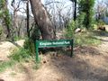
20m or so off the Old Kinglake Road in the Kinglake National Park
Participants
Kozz
Kozz's partner
Kozz's dog
Plans
Heading out around 3pm - will arrive round 4pm hopefully.
Expedition
We spent most of this morning and early afternoon doing chores, and were totally over it by mid-afternoon. I took a quick look through Ekorren's Anthill hash calculator and saw there was a relatively nearby hashpoint, which in turn was reasonably close to an early hash in the Yarra Valley.
We plotted the course, again taking us up through the Black Saturday-affected fires, and jumped in the car with the dog. The drive was awesome again, through beautifully contoured countryside in Warrandyte, where rich people with great big estates live.
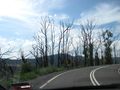
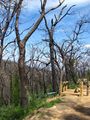
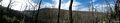
Close to the hash in the Kinglake park, it became really really apparent that the fires had gone through the area with a vengeance. Even with the regrowth and undergrowth all around, the trees still look like someone dropped bombs on the area.
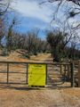
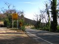
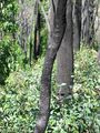
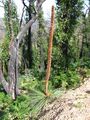
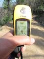
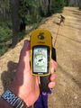
We pulled up to the entrance to the Old Kinglake Road, which is actually a track with no vehicular access. The Garmin told us we'd need to walk roughly 1.3km to the hashpoint, so we set off down the track, admiring the beautiful scenery around, including the regrowth, grass trees, ferns, and undergrowth. It made an incredible contrast against the charred trunks of the dead trees.
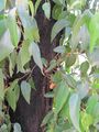
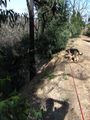
The hashpoint was under 10m from the road, which kinda counted, but there was easy access to the actual point proper without affecting plant life, so I walked to the point (within 38cm) and took photos. There was some fused glass nearby - presumably from the fires - plus lots of burnt sticks lying around. I left a hashmarker, took photos, then we wandered back up the hill and went home.
Photos
Driving through burnt forests
Bushfire recovery warning signs
The trail in
1.3km down this track
Bushfire scars
Grass tree
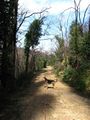
Kozz's dog is awesome
Regrowth closeup

Steep drop-off
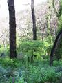
Beautiful regrowth
190m to go
Much steeper
Within the circle but on the path
Hashpoint thataway
Very close
On the spot
The hashpoint
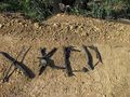
Marker goodness
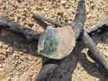
Molten glass
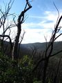
Hills
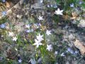
Pretty flowers
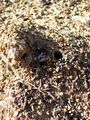
Anthill - thanks Ekorren!
Warnings on the road out
Hashpoint is on public territory
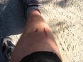
Raptor wounds
Hashpoint pano

Burnt trees pano


Kozz earned the Velociraptor Geohash Achievement
|